Patchy week of waves ahead; next week looks very good

South-east Queensland and Northern NSW Surf Forecast by Ben Matson (issued Monday 25th March)
Best Days: Hard to be confident in any great days this week due to tricky winds and flukey swell sources. Thurs prob your best chance in Northern NSW with a S'ly groundswell and winds going variable. Next Mon onwards: quality E'ly swell with mainly good winds for the points.
Recap: Easterly swells maintained fun waves all weekend, slightly bigger than 2ft though generally just shy of 3ft at most open beaches (though I did observe a half-hour period of head high sets in the Northern Rivers Sunday morning). Winds were mainly offshore Saturday morning ahead of developing northerlies into the afternoon, and Sunday delivered a slight curveball in the form of a small, unexpected coastal trough that briefly swung local winds to the S/SW early morning (arriving Coffs 4am, Yamba 5:30am, Byron 7:30am, Cooly 9am). This seemed to disrupt the early stages of the developing northern flow across SE Qld and Far Northern NSW, resulting in an extended period of variable winds for the Gold Coast and Northern NSW coast down to about Yamba (northerlies freshened across the Sunny Coast and south from Coffs as expected). Today has seen freshening northerly winds and small, easing E’ly swells.
This week (Mar 26 - 29)
Today’s Forecaster Notes are brought to you by Rip Curl
*this week's Forecaster Notes will be occasionally brief and erratic, as Craig is on annual leave - to receive notification when they’re updated, please update your account preferences*
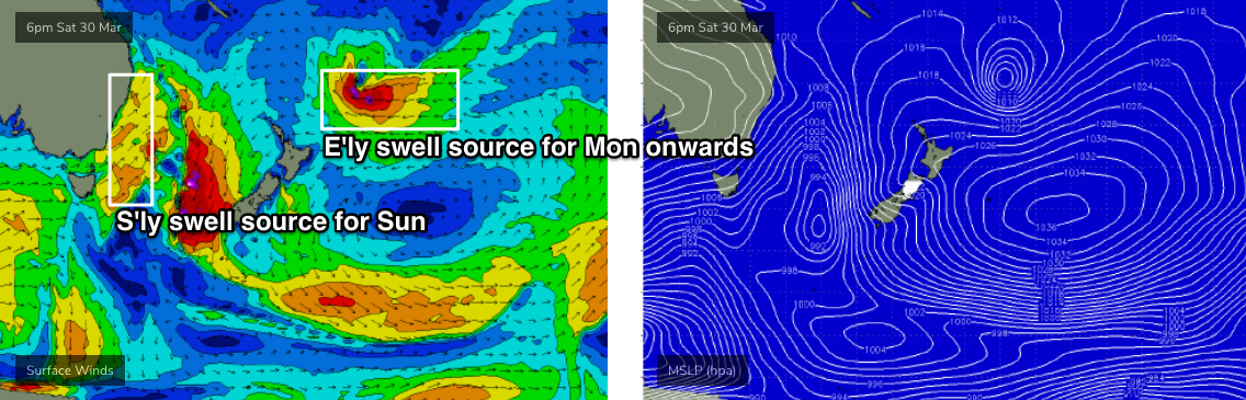
Our eastern swell window is a little quite at the moment, but not totally inactive. We’ve got a broad regions of trades south and south-east from Fiji (attached to a developing tropical low, that’ll provide good surf for next week) but ultimately wind speeds are not strong enough to overcome the large travel distance between the swell source and the mainland.
We’ll see small regions of E’ly winds nose west of New Caledonia throughout the week, but with no strength nor consolidation, I can’t see much size or energy developing from this region for a few days. probably the best chance is a small trough developing off the coast later Tuesday and Wednesday, that’ll kick up some short range energy through Wednesday and Thursday, but I’ll be surprised if we saw much more than 2ft+ at exposed beaches, with not enough energy for the points. Otherwise, expect small, slow, inconsistent, lacklustre E'ly swells that'll be tidally-affected and only favourable for swell magnets during those brief periods when winds are light and variable. How d'ya like your chances?
Elsewhere, we have a stronger swell source for Northern NSW this week though. And, it’s a doozy, though poorly aligned with our swell window.
A large, powerful Southern Ocean low is tracking south of Tasmania, and significant wave heights at the Cape Sorell buoy (Tasmania’s West Coast) jumped from 2m to 6.5m in six hours this morning, with maximum wave heights pushing above 12m (~40ft) - though a lot of that energy is local windswell (and, it's all inside the Tassie swell shadow anyway).
Nevertheless, it’s quite an incredible system and even though it’ll be aimed outside of our swell window tomorrow morning as it clears east of Tasmanian longitudes, we’ll see a healthy percentage of southerly groundswell spread up the East Coast.
Late Tuesday (Mid North Coast) and early Wednesday will see an initially small increase in south swell, originating from westerly gales exiting eastern Bass Strait this afternoon. Unfortunately, the models have edged the wind direction straight west, even a touch W/NW) instead of Friday’s suggestion of a more W/SW flow, and this has a significant bearing on surf potential. By and large, most beaches will completely dip out, but south swell magnets should see occasional 1-2ft sets as the energy glances the coast.
A trough will push up the coast on Tuesday, with S’ly winds in its wake (reaching Coffs mid-late morning), though it won’t get much further north than about Yamba or Ballina. As such, N/NW winds ahead of it across SE Qld will become variable into the afternoon as the trough settles. Local windswells will develop in its wake.
On Wednesday afternoon (Mid North Coast) and Thursday (remaining Northern NSW coasts), the bulk S’ly groundswell energy will fill into the region, in association with a couple of individual pulses. So, this won’t be an upwards-peak/plateau-downwards swell event; instead we’re likely to see the energy ebb and flow over the following forty-eight period. In fact the biggest surf may not eventuate until later Thursday, easing into Friday.
We’re likely to see wave heights pulsing between 3ft and 5ft at the height of the event at south swell magnets south of Byron, but your mileage will vary both days because each swell will have slightly different periods that’ll translate to a range of wave heights at each beach. But as always, expect much smaller surf at beaches with less southerly exposure.
This swell won’t do much across SE Qld coasts either, so you’ll be relying on short range E/SE swell here, with mainly fresh SE winds Wednesday, easing into Thursday and tending variable in some regions, before N’ly winds redevelop on Friday.
This weekend (Mar 30 - 31)
Saturday looks to be a write-off with strengthening N’ly winds ahead of a gusty S’ly change pushing up the coast throughout the day.
We’ll see a small mix of local windswell and distant though gradual building E’ly swells from the trades developing north of New Zealand this week, but no major size is likely.
Sunday’s gusty southerly change won’t have much quality surf trailing behind; the source fetch will actually be more S/SW (parallel to the NSW coast - see chart below) so south facing beaches south of Byron may see 3-5ft windswell throughout the day but it’ll be much smaller at locations offering protection form the wind. And we won’t see much size north of the border either - mainly energy from other sources.
Let’s take a closer pass on Wednesday. But don't get excited about your weekend's waves.
Next week (April 1 onwards)
A strong polar low and front associated with the weekend’s change will maintain southerly swell across Northern NSW through the start of next week, at this stage holding inconsistent 3-4ft sets at south facing beaches south of Byron through Monday and Tuesday.
A tropical depression is beginning to form near Fiji and will probably evolve into a tropical low as it tracks slowly south-east. Pushing up against a large high east of New Zealand, we’ll see a long fetch of E’ly winds form within our E/NE swell window later this week, though the swell we see from this won’t start to properly show until sometime on Monday, building towards a slow plateau in size through Thursday, Wednesday and then easing from Thursday.
At this stage, I’m expecting very inconsistent sets anywhere from 3-5ft at exposed beaches, and early indications are that winds will hold out of the south so conditions should be great across the regional points.
Looking further ahead, and there are indications that a broad ridge will rebuild through the northern Tasman Sea, generating strong E’ly swells into the following weekend and beyond.
All in all, a very good period of waves ahead beginning next week.
See you Wednesday!
Comments
I almost would have put money that some version of that would be the headline.
The old pot of gold at the end of the rainbow keeps stretching out into the middle distance.
Gotta happen sooner or later though.
Last week charts were looking great for end this week, as has been per last couple of months it changed.
Jeez I hope this ‘good surf coming’ quote is right. Doesn’t have to be Oma good, just clean 4 foot beachie good.
Personally speaking, that would be better* than Oma, as the crowd will be spread out!
Agree. I’m not a fan of majorly hyped point only ‘swell events’.
“Next week looks good”
- last 7 weeks
For fark sake give it a rest
Eh? What's your specific gripe?
Jeez dude, it's not like he puts in the order for waves, just tries to predict it it comes.
Mate, you gotta take it for what it is...forecasting.
Same as any weatherman, they have a high error rate.
High error rate?
Really?
Great question and thanks for asking....
The Short Answer: A seven-day forecast can accurately predict the weather about 80 percent of the time and a five-day forecast can accurately predict the weather approximately 90 percent of the time. However, a 10-day—or longer—forecast is only right about half the time. And this is just about the weather, not whether we will get any swell from it.
aha, oh curlyalex, you put your foot in it on that one!
Spring is the new Autumn
That would be OK as long as Autumn wasn't the new Spring.
March has done a pretty good impersonation of October or November. Pissant little swells, weak troughy changes, afternoon storms, northerly episodes, heat etc etc.
6 months with a single swell event (Oma) that has to be a record low point. The rest a blancmange of babyfood and onshore easterly gurgle.
Meanwhile models continue to struggle to resolve anything medium/long term resulting in an endless procession of fantasy charts, calls and then downgrades.
How long can this go on for?
Till I leave again seems to be the answer to that question.
I got here in mid October and it seems to have been mostly below par since. Still a few waves , fun at times , but the locals are crying hardcore about the state of the waves compared to what they’re expecting.
I bailed to Indo for a couple of weeks in December and that was uncharacteristically shit too. Extremely so. Relentlessly bad Unseasonal winds .
I usually land on my feet wave-wise wherever I go. Strange cause I’m here on a good karma mission. Maybe the planets will realign when I return to being a prick again ?
I thought for sure it was going to pump at home whilst I was away for three weeks on a risky off-season surf trip.
So glad I managed to get away from the gurgle.
It was a trip of thirds...one week of barely surfable waves, one week of good waves and one week of maybe the best I've ever had in the region.
I'd be going crazy by now otherwise...
Day 1 kickoff for the Pro?
possible hey.
Southerly direction of wind and swell could be just in the nick of time for the bank.
I think skepticism, even extreme skepticism, is warranted when looking out further than 36-48hrs.
Couldn't agree more.
hey lads , I know this is off topic , but heading to indo on a boat trip either telos or ments anyone keen to give their input on a surf report, its a boat full of intermediate surfers with a couple of blokes who don't mind a bit more size , bit unsure on the wams and what it will be like on the ground out there
cheers fellas
fyi redirect if need be
leave padang on Monday fyi 1/4
Your going anyway, what does the forecast matter? I’m sure your skipper will put you in the right places.
2-3ft of peaky E'ly swell showing at D'Bah.

