Plenty of surf for quite some time but poor winds across most coasts

South-east Queensland and Northern NSW Surf Forecast by Ben Matson (issued Wednesday 12th December)
Best Days: No shortage of sizeable surf throughout the forecast period (excluding Thurs and early Fri), but local winds will create problems most days. Sat PM and Sun has potential for lighter winds in SE Qld but likely just the Sunshine Coast. Mon/Tues also has potential for large surf, with wave heights, local winds and thus rideable prospects highly dependent on the position and strength of TC Owen (again, more likely further north than south).
Recap: Easing E’ly swells and mainly light winds with sea breezes have provided fun waves across most open beaches over the last two days, though it’s become a lot smaller as today has progressed.
This week (Dec 13 - 14 onwards)
Today’s Forecaster Notes are brought to you by Rip Curl
The synoptic charts are about as complex as they can get.
However, despite an abundance of surf in the outlook, local winds will create problematic conditions for almost the entire period.
At the moment, there’s not much visible on the analysis charts - we’ve got TC Owen redeveloping in the Gulf of Carpentaria, a small Tasman Low pushing towards New Zealand that’ll generate a small SE swell for Northern NSW late Thursday and Friday, and an advancing cold front from the Southern Ocean that’s expected to stall, and intensify a broad trough over the eastern states over the next few days.
This inland trough will be broad and complex under a regional blocking pattern, and will be the ultimate driver of strengthening coastal N’ly winds through Thursday and Friday.
We’ll see windswells build concurrently along the coast but it’s hard to imagine there’ll be many, if any locations favouring this swell direction that’ll handle the associated wind. A slight eastward extension of the trough out into the Tasman Sea on Friday will likely be confined to locations south from Seal Rocks, so this brief respite may not even be felt across our region either.
So, batten down the hatches. It’s going to get very windy, and there’s not going to be much surf to work around.
This weekend (Dec 15 - 16)
Later Friday and into Saturday, TC Owen is expected to track back across Cape York Peninsula and into the Coral Sea, before tracking south-east parallel to the Qld coast, enroute to about Gold Coast latitudes by early next week.
Although the inland trough over the eastern states will remain almost stationary, a small extension of this trough off the Central Qld coast will assist in swinging the predominantly northerly coastal airstream clockwise around to the north-east across SE Qld, and more east-northeast throughout SE Qld.
However, it’ll likely remain at strength for the most part. The trough extension will probably track slowly south as TC Owen approaches from the north, so we may be fortunate enough to see an easing of the NE tending E/NE winds later Saturday and into Sunday across some SE Qld regions, but at this stage (if the modelling is to be believed) it will probably be confined to the Sunshine Coast.
South from the Gold Coast - and more definitively the Byron Coast - winds will remain gusty cross-onshore all weekend.
The weekend’s surf estimates are rather large, but only because of this sustained local fetch - it’ll mainly consist of windswell (trending to more of a ‘storm swell’ as wave heights increase above 4-5ft). And with winds out of the north-east quadrant, there won’t be many places to hide.
So, for most locations - keep your expectations pegged very low this weekend, but there is a chance that we’ll see windows of opportunity open up throughout SE Qld, more likely the Sunny Coast than anywhere else.
Next week (Dec 17 onwards)
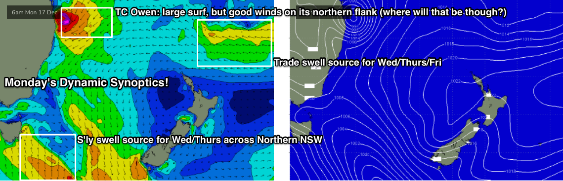
TC Owen’s projections for next week are quite some time away - given the complex, dynamic forecast outlook - so we have to be very careful assessing surf potential for the long term.
But, its fair to say that we’re looking at some pretty large, windy conditions on Monday: our wave model is estimating over 5m of E/NE swell at 10+ seconds, roughly translating into 12-15ft surf on the Gold Coast.
Of course, with (modelled) gale to storm force onshore winds, there won’t be any surfable options. However as TC Owen tracks south, the return flow on its northern flank will swing offshore and this will quickly clean up whatever mess is generated ahead of its arrival.
As such, the key to scoring good surf next week will be reliant on exactly where TC Owen is positioned.
That being said, if it remains at strength there may simply be too much size for exposed coasts anyway. Let’s just roughly stamp it as ‘very large and generally wind affected’ for now, and see how the model updates are handling things on Friday. It's very likely that TC Owen will influence our surf outlook for at least the first half, and possibly the second half of next week, though the largest, windiest conditions will probably be at the front end.
Looking further afield, and the inland trough will move into the Southern Tasman Sea on Monday, forming a new low pressure system, and generating a new southerly swell. No great size is expected at this stage - we’ll probably see south facing beaches south of Byron deliver 3ft+ sets through into the middle of the week but TC Owen will probably overshadow everything for much of that period anyway.
Elsewhere, and this Tasman Low will likely remain a source of (probably small) SE swell later next week and into the weekend, whilst a decent fetch of trades north of New Zealand from this Sunday onwards will generate small but useful E’ly swell mid-late next week too. Though again, probably overshadowed by TC Owen.
So yet another complex surf outlook. See you Friday!
Comments
A few north facing PB could be the go?
Yippie, no banks, gutters and brown water just in time for Xmas....
Great beachies the last couple of days. A few chunky peaks in the mix. Was worth the wait. The forecast on the other hand looks like a bank buster.
Let's hope the latest EC forecast comes to fruition and Owen staysup north and decays rather than parking off the SE QLD coast for a bank busting affair.
At least the point banks are already rooted
TC Owen has been upgraded for its Gulf Tour: already Cat 3 and may reach Cat 4 later today. This development has little bearing on our surf outlook, but regardless.. what a system!

Banks are still fcuked from the October Fraser Island low so no biggie if we get another reset.
Good flush of the rivers wouldn't be the worst thing either.
Could get some racy lefts to zoom along. Looks like Media hype might frightened poor Owen out of our sector. Where is it that useful east swell?
Will be a few more days until we can be truly confident on TC Owen’s potential. Cyclone swell potential is notoriously fickle at the best of times, let alone those originating from continental sources.
Looks like the models have shat themselves and gone 4ft NE
you don't surf anyway
It could start to crank. I feel.