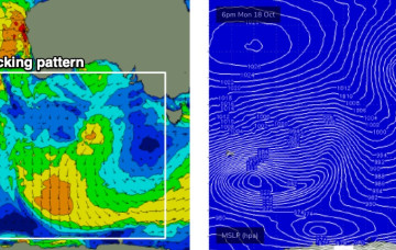
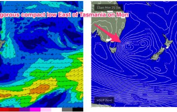
Unruly mix of swells as robust Tasman low forms off East Coast on the weekend
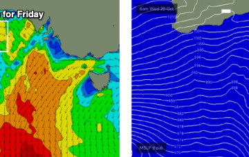
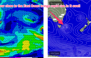
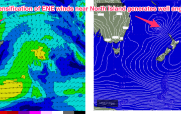
A dynamic weekend is ahead as a robust Tasman low forms near the Island overnight Sat.
The current Tasman low has drifted out and become absorbed into a long, NE/SW angled trough in the South Pacific, which is currently organising and energising a broad but thin fetch of E’ly gales from the South Pacific down into the Tasman Sea adjacent to the North Island.
The low has now passed through the area and is weakening in the Bight, with a long trailing fetch of W’ly winds bringing continued onshore conditions as local storm surf slowly eases back through tomorrow.
A thin front traversing the western Bight is generating a small new W’ly swell that’s expected to provide a small flush of surf to the Mid.
There’s not a lot of juice left in the tank.
Current ASCAT (satellite windspeed) passes show a broad fetch of E to ESE’ly winds feeding into the small low east of Tasmania, with another weak low centre off the NSW Mid North Coast also providing a weak E’ly fetch.
These swell trains are generated as a deep, angled trough through the area between the North Island and New Caledonia merges with the remnants of the Tasman low and focusses E to ENE winds in a broad area near the North Island during Friday.
The interplay between the two systems is producing a fetch of E/SE winds through the Central Tasman, in effect a sub-tropical looking tradewind style fetch we might see in Summer.
Forecast data looks uninspiring for the rest of this week, but we should see small leftover waves for the next few days thanks to a trailing polar low/front below the state yesterday that’s generating some minor S/SW swell for our region.