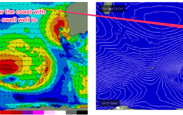
Brief windows ahead, including one day for the Mid
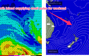
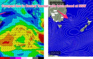
Wednesday looks to be the pick of the forecast period down south. The Mid has good options lining up for the weekend.
The first blast tomorrow will be increasing N/NW windswell, with increasing N’ly winds tending NW through the a’noon and potentially becoming gale force, especially on the Bunbury to Perth stretch.
Easing swells are expected from Tuesday onwards, but the main issue we have for the short term - at least, west of Melbourne - is a developing south-easterly airstream on Tuesday that’ll veer gusty easterly into Wednesday.
A trough in the Tasman off the NSW coast deepens into a small, surface low through Tuesday. Compared to model runs on Friday, this slow moving low is now positioned further south, in a more favourable position for swell generation for the East Coast of Tas.
From tomorrow we see a large, southwards located high and multiple troughs located in the Tasman sea and inland become the dominant synoptic features for the week. This is going to set-up some tricky, short-lived fetches as well as another week of multiple wind changes.
From there we see a large, southwards located high and multiple troughs located in the Tasman sea and inland become the dominant synoptic features for the week. This is going to set-up some tricky, short-lived fetches as well as another week of multiple wind changes.
Give tomorrow a miss and aim for a surf over the following days when cleaner conditions and fun surf is still expected.
NE windswell is on the way out through tomorrow as the fetch gets shunted eastwards and away from the swell window but a complex cut-off low quickly replaces that swell with chunky short range S swell as it tracks just to the East of Tasmania and brings strong to gale force SSW to S winds.
Easing surf with deteriorating conditions over the weekend, worsening next week as a severe, slow moving mid-latitude low moves in from the west.
Very dynamic, unstable week ahead that has a very La Nina looking signature to it. Primarily the strong, southwards located high and a very troughy pattern in the Tasman sea, that has good swell potential for the region.