Severe low inbound next week

Western Australia Surf Forecast by Craig Brokensha (issued Friday October 15th)
Best Days: Today, protected spots tomorrow morning in the South West, early Perth and Mandurah for the keen
Features of the Forecast (tl;dr)
- Easing SW groundswell tomorrow with S/SE tending S/SW winds in the South West, NE tending W/NW to the north
- Smaller Sun with W/SW winds (possibly variable early)
- Building N/NW windswell Mon with strengthening N/NE tending N/NW winds, larger Tue with developing gale-force N/NW winds
- Large, stormy W'ly swell Wed with strong to gale-force W winds, easing Thu with abating winds, possibly variable Fri AM
- Large SW groundswell building Fri PM, easing Sat
Recap
Great surf across the South West most of yesterday with offshore tending variable winds and 4-5ft surf on the reefs, while today we've got a peak in new SW groundswell with great 6-8ft sets across the South West. Conditions were windy but then tended variable ahead of a strengthening sea breeze.
Mandurah was a fun, clean 1-2ft yesterday and this morning, similar in Perth yesterday but back to 1-1.5ft today. There should be a little more size showing through the day on these coasts.

Glassy and stacked just ahead of the sea breeze
This weekend and next week (Oct 16 - 22)
We'll see today's good SW groundswell easing back in size a touch later this afternoon in the South West, while tomorrow morning should reveal smaller, easing 5-6ft sets, 2ft on the best ones in Mandurah and 1ft to possibly 2ft in Perth.
Winds won't be as favourable as a deepening trough come mid-latitude low develops along our coast and drifts south, bringing fresh S/SE winds to the South West, NE-N/NE in Perth and Mandurah before shifting onshore from the W across northern locations and S/SW in the south.
This will be the start of a run of poor conditions and average surf so make the most of the waves today.
Winds will be lingering onshore into Sunday on the backside of the low and out of the W/SW along with a low point in swell. There might be variable winds at dawn but it's not worth setting the alarm early for.
We'll then see wind strengthening out of the northern quadrant early next week as a high riding and deepening mid-latitude trough come low forms west of us, directing a strengthening fetch of gale to severe-gale winds into the central parts of the state, mostly north of Margaret River's swell window.
This will see Perth and further north copping the brunt of the swell and winds, but that's not to say Margaret River will miss out.
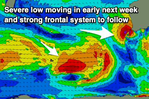 It looks like the system will see a slow moving, rotating low with a few intensifications and quite severe when it moves in. Firstly strong N/NE tending N/NW winds on Monday will kick up a weak N/NW windswell, with gale-force N/NW winds developing Tuesday, producing even more size.
We're then expected to see W/SW gales pushing in Tuesday evening, bringing an oversized, stormy swell to the region.
This will cause lots of erosion with stormy 4-6ft waves in Perth, possibly bigger in Mandurah and to 10ft or so in the South West. Winds will be strong to gale-force from the W and there'll be nowhere to hide.
Behind the low, little short-wave features (read fronts) will keep onshore winds hitting the state into the middle to end of the week, from the W/SW on Thursday, possibly more variable on Friday. There's also a chance for S/SE winds around Mandurah Thursday morning with the easing stormy swell, but we'll have a closer look at this on Monday.
Longer term there's plenty more frontal activity firing up through our swell window later next week, generating moderate-large pulses of swell into the end of the week and the following week though winds are a touch dicey. One of these, shown in the chart above looks to produce a good swell for Friday afternoon, but check back Monday for more on this. Have a great weekend!