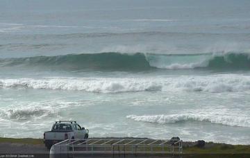
Small swells, cleanest as they ease
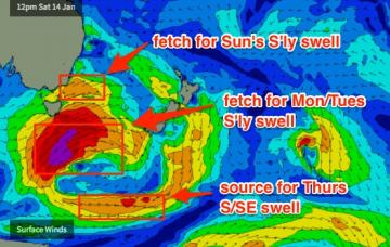
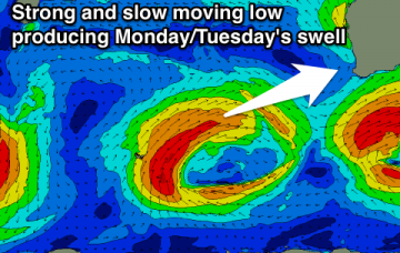
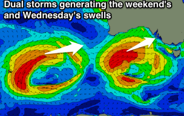
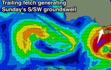
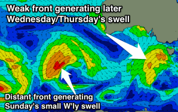
Small clean leftovers tomorrow morning, with a mix of new swells building Wednesday and peaking early Thursday but with onshore winds. Cleaner and easing Friday.
In short, Mid North Coast has potential Saturday, everywhere else for Sunday. But keep your expectations low and your eyes peeled for windows of opportunity.
As we’re already seeing 2-3ft sets across NE facing beaches late this afternoon, this size range should be present for the dawn patrol but get in early as it’ll ease throughout the day.
Tiny tomorrow with a building S'ly swell later Sunday, easing slowly Monday with favourable winds. Small fun S/SE swell for Wednesday through Friday.
Tiny tomorrow morning, with a rapid increase in raw W/SW swell tomorrow afternoon and evening, peaking out of the SW Sunday morning and then easing out of the S/SW Monday.
Good easing SW swell tomorrow with offshore winds, average Sunday. Good new W/SW swell building Monday but with an onshore wind, cleaner and slowly easing Tuesday and Wednesday.
Large onshore swell building tomorrow, easing Sunday, with a reinforcing S/SW pulse down South, along with E/SE winds. Best down South Monday morning.
Large building W/SW groundswell Saturday with a good W/NW wind for the Surf Coast Saturday morning and early afternoon. Easing W/SW and new S/SW swell Sunday with early W/NW breezes around Torquay. Light winds and easing surf Monday.
Moderate to large NW swell for Hawaii tomorrow, followed by an XL swell Friday afternoon, easing Saturday. Another longer lived XL swell from the W/NW Wednesday through the end of next week.
The anchored E’ly fetch south of New Caledonia and Fiji over the last few days is generating a minor bump in size that should arrive overnight, and show best early Thursday morning.