Fantastic weekend of waves ahead for Northern NSW and SE Qld

South-east Queensland and Northern NSW Surf Forecast by Ben Matson (issued Monday 4th July)
Best Days: Tues: possible small afternoon window on the Goldy and in Far Northern NSW, with a minor N'ly swell and winds tending NW. Thurs/Fri: building S'ly swell in Northern NSW (poss solid Fri), but probably remaining small in SE Qld. Sat/Sun: fantastic S/SE tending SE swell across all coasts with good winds. Sunday the pick, esp in SE Qld.
Recap: A fun south swell built across the Northern NSW coast on Saturday, reaching 3ft+ at south swell magnets late afternoon and holding at around 3ft early Sunday morning before slowly easing throughout the day. Locations not completely open to the south were smaller and unfortunately much of SE Qld remained tiny due to the swell direction. Today we’ve seen tiny leftovers across most beaches with clean conditions under a light offshore breeze.
Next week (Tuesday July 5th - Friday July 8th)
No major changes to the short term forecast.
We’ve got very little groundswell on the way for the next few days; the only source of new energy is a pre-frontal N’ly flow expected to develop off the Southern Queensland and Northern NSW coastline tomorrow. This should generate a brief N’ly swell Tuesday afternoon for exposed north-facing beaches on the Gold Coast, and Far Northern NSW coast down to about Yamba, with set waves peaking in the 2ft+ range late in the day. Smaller surf is likely along the Sunshine Coast (owing to the shorter fetch length) and across the Mid North Coast (owing to the less favourable coastal alignment).
The main thing to keep a watch on will be surface obs to the west of us, as we’re looking at winds veering NW throughout the afternoon and this should clean up conditions across the beaches (it’ll be sideshore and bumpy prior to then, and also undersized early morning). Keep your expectations low and you might find a few funky left runners down the beaches for the late session. I'll update in the comments below as relevant data comes to hand.
Tuesday’s northerly windswell will then be all gone by Wednesday, with tiny leftovers brushed clean by a fresh W/SW wind as a new low pressure system forms off the Far South NSW coast.
Initially, this system looks like it’ll be poorly positioned for anywhere north of Seal Rocks; in fact it’s going to take a few days before we see the true surf potential appear from this source. However it is shaping up to deliver some excellent waves in the long term so hang in there.
On Wednesday, the low will tightly hug the Southern NSW coastline, generally positioned outside of our swell window. As the low tracks slowly eastwards into Thursday, a new southerly fetch is expected to develop off the Mid North Coast and this should start to generate an upwards trend in short range south swell though it may be a little windy to begin with, at locations south of Coffs.
A better S'ly fetch further south will generate stronger groundswell lines for Friday from about the same direction.
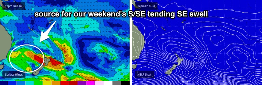
It looks like this short range S’ly fetch will dissipate into Friday as a broader, stationary SE fetch develops along the low’s southern flank, encompassing almost the entire width of the southern Tasman Sea. This is quite an impressive setup, and with the low expected to remain slow moving right through into the weekend and beyond, should generate a long lasting, high quality S/SE tending SE groundswell for the entire East Coast.
Initially, this SE fetch won’t be perfectly aligned within our swell window (on Thursday) but it’ll slowly slide into an optimal position (north-east Tasman Sea) through Friday and Saturday. This means we can expect surf size to slowly increase from Thursday through Friday from the south, and then from the S/SE tending SE through the weekend and early in the following week, as the quality continues to improve.
Concurrently, as the low pushes away from the coast we should see local winds relax and become light and variable both Thursday and Friday.
So, current expectations are as such:
Northern NSW: Building S’ly swell on Thursday from 2-3ft to 3-5ft at south facing beaches (building quicker on the Mid North Coast), with a longer period S’ly groundswell filling in on Friday and size building further to 4-6ft at south facing because. Smaller surf at remaining open beaches (1-2ft building to 2-3ft Thurs, then 3-4ft Fri).
Southeast Qld: Tiny surf for much of Thursday with a late pulse in S’ly swell, best suited to south swell magnets with sets up to 1-2ft. Friday should see a small increase with 1-2ft waves across most SE Qld beaches by mid-late afternoon (smaller earlier), up to 2ft+ at some outer points and 2-3ft at a handful of reliable south swell magnets.
This weekend (Saturday July 9th - Sunday July 10th)
Looks like an unreal weekend of waves across all coastlines with strong, steady S/SE tending SE groundswells and mainly light variable winds.
At this stage the only discernible trend is a possible minor increase through Saturday towards a peak on Sunday, however the most notable feature is the anti-clockwise swing in the swell direction, which will mainly benefit SE Qld. For this reason, Northern NSW may not see much of a size difference between both days, but as the swell direction tends more east we’ll see a slow increase in size north of the border.
So, it’s early days but we’re probably looking at Northern NSW seeing 4-6ft surf at exposed beaches both days (give or take), with SE Qld slowly building from 2-3ft across the open beaches Saturday to around 3-4ft on Sunday; a little smaller running down the points.
All in all, it looks like you should be racking up lots of brownie points this week, as you’ll probably find a need to exercise all options to surf both days this weekend.
Next week (Monday July 11th onwards)
This broad Tasman low looks like it’ll occupy our swell window right through the weekend before drifting off to the east early next week. So, this suggests our quality weekend of SE swell will persist into Monday - maybe even with a little more east in the direction - before slowly easing into the middle of next week.
I can’t see there being much more size than what we’re expecting Sunday (on Monday) but there is a possible risk of another pre-frontal northerly flow, so let’s keep our quality expectations in check and aim to surf through the weekend instead.
Beyond that there’s more suggestions for a strong frontal passage through the lower Tasman Sea early-mid week and a strong run of south swell mid-late next week.
Let's see how the models are looking Wednesday! See you then.
Comments
Hot diggity dog, I am excited about the weekend.
Very good. Be nice to get some waves this weekend on the Sunny Coast.
Finally something to get excited about. Boo yeah
An of course i'm moving house;(
Good luck finding a bank that's not going to be either fat mush burgers or Shorey close outs.
Already 1-2ft of N'ly swell starting to show on the Tweed. Quality is pretty low but the potential is there for a late session.
Don that will be a challenge. Might have to settle with some barrel close out action.
Plenty of lines showing at D'Bah.
And lotsa lines across the Superbank too.
Not much happening on the Sunny Coast though (as expected) - Moffats is tiny.
Noosa is also tiny....
... though it hasn't stopped a sizeable group of longboarders paddling out at First Point! Dunno what they're waiting for.