Strong S/SE swell for Sun/Mon; good SE Qld points on the way

South East Queensland and Northern New South Wales Surf Forecast by Ben Matson (issued Wednesday 20th April)
Best Days: Outer SE Qld and Far Northern NSW points possible late Sat but more likely Sun/Mon with a new short range swell. Mon/Tues/Wed also looking potentially fun across inner Qld points as the swell swings more to the east, though it will be easing.
Recap: Monday’s east swell eased back to an inconsistent 1.5-2ft across SE Qld on Tuesday and Wednesday, but Monday’s new south swell hung in a little bigger and better than expected across Northern NSW (and the handful of south swell magents north of the border). In fact, there were still occasional traces lurking around this morning. Tuesday maintained solid 3ft+ sets at times, and there were still a few 3ft sets at select locations early today whilst winds were light. However this south swell is now on the way down.
This week (April 21st - 22nd)
No major changes for the rest of the week. We’re looking at mainly light variable winds and small residual swells from the east and south.
A minor bump in size is likely on Friday thanks to a broad but unconsolidated fetch currently developing in the eastern and northern Tasman Sea, around a small high pressure system to the south.
It doesn’t have a lot of strength and the fetch is split into several regions (not good for swell generation) so I think only exposed beaches will benefit from this source - however the odd 2ft+ set is likely throughout the day. Certainly not worth a day off work but there will be small waves about the swell magnets.
If you have to pick a day between the two, Friday is preferred over Thursday mainly due to the promise of a little more size. But don't get your hopes too high.
This weekend (April 23rd - 24th)
Small residual east swells from Friday will pad out Saturday; in fact we’re looking at a slightly bigger pulse of mid-range east swell pushing through over the weekend, originating from a burgeoning high pressure system pushing north-east along New Zealand’s East Coast today.
Wind speeds aren’t great within this source but the fetch is very broad, and is expected to track ever so slightly eastward. We should see an increase into the 2-3ft range at most beaches throughout the weekend, probably plateauing throughout Sunday. Expect slightly smaller waves on Saturday from this source.
However, this swell will be greatly overshadowed by a much more prominent short range swell, courtesy of a strong ridge building across the Qld coast on Saturday.
This ridge will initially form thanks to a southerly change pushing up the coast on Friday night. It should be well established across Northern NSW and possibly Southern Queensland by daybreak Saturday, but at this time there won’t have been any fetch development in our swell windows, so at face value it’ll be just a lot of wind chop to start the weekend (spoiling the small east swell in the water at the open beaches).
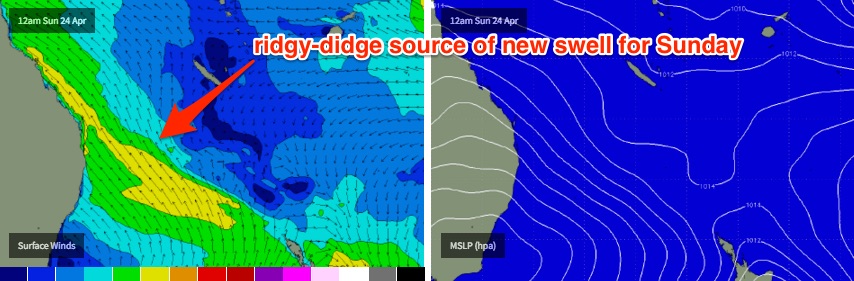
The models have strengthened this ridge (and subsequently the surface wind speeds) so the forecast for the rest of the weekend has been ramped up. However the jury is still out as to when the swell will really start to show across the SE Qld points - let’s face it, under strong S’ly winds, there won’t be many other surfable options - and the initial short swell period and southerly swell direction will severely restrict wave heights at these spots.
So let’s put a hold on Saturday afternoon’s potential north of the border, as it could be downgraded if the models stall the change by a couple of hours. Northern NSW should however see a solid building trend throughout Saturday - especially across the Mid North Coast - but you’ll have to dial into a protected southern corner for something workable.
Sunday is a much safer bet for this new ridge swell (is that a term?) with punchy short range S/SE energy expected across all coasts. In fact the latest model runs have the ridge extending into the Northern Tasman Sea at strength, which should maintain a building trend all the way through into Monday morning - though mainly across northern locations by this time.
Wave heights will be biggest at exposed south facing beaches in Northern NSW on Sunday (could be up to a junky, wind affected 4-6ft at these spots, if the models hold with their wind speed projections), whilst the outer points of SE Qld should see solid 3-4ft sets by Sunday afternoon (may be a little smaller in the morning). Even the protected inner points should see rideable wave though it will be very small due to the strong southerly component in the swell direction.
So all in all, Sunday is still your safest bet for a wave this weekend, though Saturday afternoon could throw up some mid-late afternoon potential across the outer points (and protected spots across the Mid North Coast).
Next week (April 25th onwards)
With the ridge holding steady into the start of the new week, we should see a continuation of healthy trade swell into Monday, and even Tuesday - though it will be easing by this time.
As the swell source will have moved further north over the weekend - aimed into the Coral Sea - wave heights will fall off more steadily south of Yamba. But there should still be plenty of trade swell on offer for this period. And conditions should be a little more manageable at open beaches here under a new high pressure ridge (SE Qld will still see persistent sou'easters throughout this time frame - again, favouring the points).
In fact, at this stage most of next week is looking really good for the more sheltered SE Qld points, as it looks like the ridge will remain firmly entrenched across the Coral Sea, with a better easterly alignment. This should swing the swell direction more around to the east, and its close proximity to the mainland should ensure that we don’t lose too much size either.
The longer term outlook beyond Tuesday and Wednesday has a couple of sources of long range southerly groundswell (that’ll only favour Northern NSW) and a reasonable possibility that this ridge could very well continue to supply fun workable swell across SE Qld and Far Northern NSW through until next weekend. Let’s see how the models are shaping up on Friday.
Comments
Haven't had a strong Coral Sea ridge for a little while. Looking good for surf for next week - we are definitely back on the horse!
Giddyup
You beauty. The stick went in for repairs yesterday, hopefully ready for the weekend. Shout out to Brett @ GT Ding repairs looking forward to seeing his handy-work.
Super fun beachies again this morning, mainly 2ft with the odd 3ft A-frame. Crystal clear water, light winds and zero crowds. Love autumn!
Yep, some real fun wedges around this morning. A little gurgly at dawn but improved as the tide came in. Water was getting a bit chilly for me but!!!
Yeah was a beautiful morning in the water. But smaller up here on the Sun Coast but still some fun ones.
Nice lunchtime session, still fun and not crowded at all.
Sorry lads, gonna be a little late this evening. Have to pick the grommets up from kindy.
Great lunch time surf in boardies on a beautiful day. Great left hand bank to myself. Where is everybody? Qld school hols were busy, but nsw hols no one around.