Small swells until Sunday; new south swells from Monday; getting large late next week

South East Queensland and Northern New South Wales Surf Forecast by Ben Matson (issued Wednesday 6th April)
Best Days: No great days though most beaches should have small peaky waves most mornings. Strong southerly swells due (mainly across Northern NSW) from Monday onwards, potentially getting quite large next Thurs/Fri.
Recap: Building trade swell through Tuesday, which reached a peak in the afternoon and plateaued into this morning. No major signs of an easing trend yet, though the swell is somewhat lacking in power. Early light winds and sea breezes in most locations, except the Mid North Coast where we are seeing freshening nor’easters.
This week (April 7th - 8th)
No major changes for the rest of this week.
A broad ridge across the Coral Sea is retreating eastwards, and as this is the source of our current tradeswell, we will see a corresponding slow easing trend across the coast.
Thursday’s wave heights will see a similar regional distribution of size as per today, biggest on the Sunshine Coast (peaky 3ft) with smaller waves as you track south, around 2-3ft on the Gold Coast through to Ballina then 2ft across the remainder of Northern NSW). Keep in mind that low swell periods and a large tidal cycle will result in generally slow, fat waves on the early incoming tide. And, surf size will be smaller across the points and other protected locations.
Local winds should be light and variable early, with sea breezes in the north but freshening northerlies across the Mid North Coast during the middle of the day as a shallow front approaches from the south. This may result in a southerly change up to about Port Macquarie late afternoon but I don’t think there’ll be much in it.
A small long period southerly swell is expected to arrive across the Mid North Coast after lunchtime on Thursday, but there probably won’t be much size in it. This swell will have originated from a powerful but poorly aligned front that tracked south of Tasmania yesterday. We may see some rogue 2ft+ sets at swell magnets late afternoon, extending to the Far Northern NSW coast (up to Byron) on Friday. Keep your expectations low though.
Thursday’s late, shallow southerly change will peter out overnight leaving Friday with light winds again before afternoon sea breezes kick in. The east swell will have eased further by this time (2ft+ across the Sunny Coast, trending smaller with increasing southerly latitude).
We should also see a secondary mid-range south swell on Friday, generated by a modest fetch trailing Thursday’s shallow change. In general it looks pretty average on the synoptic but south swell magnets should pick up occasional 2ft+ sets (interspersed with the inconsistent long period energy). Exposed beaches in the Far North could see some fun waves early Friday with this triple-combo of small swells and light winds, but on the balance it’s not worth too much attention.
Elsewhere - especially across SE Qld - expect small, slow peaky waves to finish the working week, and aim for an early session.
This weekend (April 9th - 10th)
I’m still expecting small swells and light winds for the weekend. All of our common swell windows will remain inactive over the coming days so we’ll mainly be relying on residual energy to keep the swell magnets humming.
The "weak low pressure system off the central NSW coast on Friday” mentioned in Monday’s notes has largely disappeared from the charts, but there’s still a lot of instability across the Tasman Sea (plus a new possible swell source further east, on Saturday) - and there’s always potential for an upgrade. So I’ll take another look on Friday but I can’t see there being much of an improvement, if any.
Otherwise, we are still looking at a small long period south swell arriving across the Northern NSW coast on Sunday. The latest model guidance has slightly sped it up and also increased the size potential, so we should see some fun surf building to 2ft, maybe even 2-3ft at some of the region’s more reliable swell magnets (note: there may be a minor delay on this swell in the Far North). I’ll asses the data more comprehensively on Friday but for now this south swell probably looks like it’ll be the highlight of the weekend, assuming you have access to an exposed south friendly location. Everywhere else will remain pretty small.
As for winds - no major strength expected this weekend, mainly light and variable in the morning and afternoon sea breezes, possibly from the north-east.
Next week (April 11th onwards)
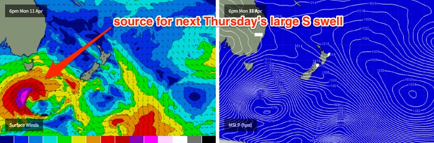
As I suggested in Monday’s notes, we have a strong frontal progression expected next week and it’s going to deliver an extended period of sizeable southerly swells for the NSW coast.
The first front is due to round the Tasmanian corner on Sunday, and we’ll see a new swell build throughout Monday, followed by a followup pulse on Tuesday. Whilst we won’t see much, if any size from this swell in SE Qld away from the south swell magnets (due to the direction), exposed locations south of Byron could see 3-5ft sets from this source.
A second, much stronger and more favourably aligned front trailing behind is then expected to generate a very large south swell for the middle of the week. At this stage late Wednesday may see the leading edge hit the Mid North Coast, but in general most locations are looking at a Thursday arrival of strong, long period southerly swell that could reach 6-8ft at some of the coast’s most exposed south facing spots (expect smaller surf elsewhere, due to the direction).
SE Qld won’t see anywhere near as much size, probably just a couple of feet at most beaches but maybe between 3ft and 5ft at the region’s handful of south swell magnets.
This swell should continue into Friday with another followup swell maintaining large surf at exposed south facing beaches, though with a slight downwards trend that’s likely to persist into next weekend.
So all in all - we’ve got plenty of south swell on the way. Tune in on Friday for a more comprehensive update.
Comments
Autumn: the return of the southerly regime. Sounds like a Star Wars movie.
I would have called it 'Return of the whinging queenslanders'.
Maybe the first dump of snow above 1200m Deep South En-Zed:) Monday!
Lostdoggy, cmon mate. Nothing to whine about here. Great fu%#$n year of super fun / Super crowded Snapper, however I managed to snag 4 beauties in 4 hrs. Yep I hate and love that place for those Epic waves you eventually get. Solo Surfer from QLD that hates overcrowded line up , yet appreciate s just how good QLD Waves are. Nth NSW boy. Go get lost in a place you have never been b4 . Adventure Lost. Proud Queenslander. !! Sorry for vent but don't dis my State. Cheers big Ears
Good stuff, mate.
Qld has had an epic season. Was just a joke about how all the talk will be about south swells for a while and some of you guys seem to feel left out each year. Gotta take the epic with the quiet, hey?
Burleigh was barrelling but hard to find many exits. Gotta love da Goldy , People are nice n happy like my Nth NSW real surfers. Angas to D.I.P. is Huey's (God) country. Peace !!!
I was hoping for one more great east swell before the loom and glom.Ohh well time to start planing the indo trip.
Gee long range charts are all hinting at a pretty impressive sustained period of tradewind swell/E'ly groundswell coming our way.