Terrible mid-week surf; Friday onwards looks fantastic

South East Queensland and Northern New South Wales Surf Forecast by Ben Matson (issued Monday 1st February)
Best Days: Nothing happening until Thursday when we're expecting a S'ly change and a kick in short range windswell. This will really motor into gear on Friday - though very south in direction, and very windy - with the weekend shaping up to deliver solid SE swells and fresh, gusty S'ly winds. Great for the points!
Recap: Some small leftover E’ly swell early Saturday, but nothing of substance thereafter (weak NE windswell) and with mainly N’ly winds it’s been a sorry state of affairs across the region for the last few days.
This week (Feb 2nd - 5th)
Give the next few days a miss. Seriously, we’re not expecting any new swell and with tricky winds it’s going to be hard to find somewhere worthwhile.
Let’s take a closer look at the synoptics though, as we have a dynamic period ahead and the end of the week through the weekend and even beyond looks mighty fine.
A complex low pressure trough over the region is expected to begin the process of generating a number of low pressure systems. Initially, they’ll be very small and inconsequential - resulting in a wind change, and nothing else (i.e. Tuesday, across Northern NSW). This pattern is expected to play out into Wednesday.
The small NE windswell present at exposed north facing beaches right now will also abate over the coming days as this swell source dries up. Not that it was producing anything worthwhile, anyway.
Although it’s not going to affect our coast, we will see an impressive NE fetch build out across the far north-eastern Tasman Sea over the coming days. This is aimed mainly towards eastern Tasmania and southern New South Wales - any locations north of here will see significantly smaller size and energy (with increasing northerly latitude) due to the narrow fetch, considerable travel distance and poor alignment.
It is feasible that we may start to see some small sideband E/NE energy from this source reach our shores - probably Thursday or Friday, and best across the Mid North Coast - but by this time there’ll be a much more useful, dominant swell train in the water from the south-eastern quadrant.
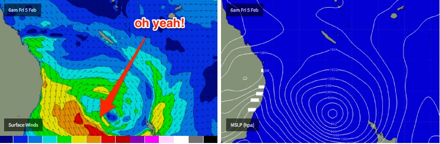
Later Wednesday, a cold front racing through the southern Tasman Sea is expected to merge with the broad low pressure trough to the north, forming an impressive Tasman Low that’s expected to encompass almost the entire ocean basin, and for quite a decent period of time. This means we’re looking at another extended swell event, but this time from the SE (initially S’ly, then S/SE before swinging SE over the weekend).
At this stage we’re looking at fresh to strong southerly winds accompanying the swell increase, and persisting for a few days at least, so your early choice of surf destinations will require some protection from the wind. And SE Qld will initially see much smaller surf due to the southerly component in the swell direction (don’t worry, this will swing by the weekend).
So Thursday will probably start off small with early SW winds in most areas swinging S’ly throughout the day, and becoming quite strong across Northern NSW, especially in the south. Wave heights should reach 4ft at south facing beaches (south of Byron) by the end of the day though it’ll be mainly low quality, short range stuff and wind affected - and there probably won’t be a lot getting into the sheltered spots either. So don't get your hopes up.
Across SE Qld, I’m expecting a very small start to Thursday, and only a minor increase through the afternoon at the outer points handling the wind (i.e. some late 1-2ft sets). South swell magnets will obviously be bigger but wind affected.
Friday will be the best day of the working week, though the primo part of this swell will still be a few days away. Expect building S’ly swells all day, reaching 6ft+ at south facing beaches in Northern NSW by late afternoon, and 2-3ft+ across the outer points of the SE Qld points (bigger at exposed south swell magnets, but smaller at sheltered spots). But with driving southerly winds, the sheltered locations will really be your only option on Friday.
This weekend (Feb 6th - 7th)
My-oh-my, we’ve got a cracking weekend of waves ahead.
It’ll still be windy at exposed spots but the swell direction will swing around to the south-east and with plenty of size on offer - 6ft, maybe even 6-8ft sets at exposed beaches in Northern NSW, if the fetch consolidates properly - there won’t be any shortage of energy. Expect smaller, more manageable surf across the protected points however there will still be a lot of water moving.
Even the SE Qld points should pulls in a healthy dose of size from this swell as the direction clocks more east of south, somewhere in the 3ft to maybe 5ft range on Saturday if we’re lucky, easing a little into Sunday. We'll need a few things to come together over the coming model runs but right now it looks very good for this neck of the woods.
However, there'll be a strong southerly component to this swell over the weekend, so expect much smaller surf at protected points (and beaches) in SE Qld. I need to emphasise this, because on the balance, the swell direction is likely to be more southerly than easterly, and if you're anywhere north of Byron Bay, every single degree of direction matters to the eventual surf size.
Local winds look like they’ll be under the influence of a strong ridge pushing through into the Coral Sea by this point, so gusty S’lies are expected Saturday (possibly early SW in a few select locations, veering S/SE throughout the day), then a similar trend for Sunday but with a little less strength. Keep in mind that this swell direction and wind combo will probably ratchet up the sweep across the coast too.
Let’s check back Wednesday to see how things are shaping up.
Next week (Feb 8th onwards)
At this stage, I think we’ll see this low persisting in our swell window - albeit in a weakening state - until Monday or Tuesday of next week. This means we’ll probably see SE swell across the region (albeit easing in size) through until at least Wednesday or Thursday of next week.
Based on the current progs it’ll be a slow downwards trend each day but Monday should still have plenty of size on offer, and local conditions should improve too as the ridge relaxes, easing the winds.
So, if you’re looking to escape the crowds, then maybe it’s worth aiming for some flexi-time during the week after the weekend’s peak - that way most of the arms in the lineup will be quite tired. Just a thought!
Anyway, see you Wednesday.
Comments
Contest organisers must be spewing - after weeks and weeks (months, in fact!) of excellent surf on the Gold and Tweed Coasts, the Burleigh Pro (over the weekend) and the Telstra Stores Tweed Coast Pro (right now) have managed to luck into the worst spell of surf all summer.
Is there such thing as too much of a good thing. What i mean to say can mother nature use up all her energy so to speak? Didnt same thing happen for quiky pro. Great start to year then nothing left for the pro.
P.s i live in vic and gotta stop reading these forecaster notes. Its killing me haha
Awesome, this summer has been better than I expected. I might swim a few laps in the local pool to build up some paddle strength. Strong southerly winds and big swell = burning lacturals!
Ok, since you've posted a BW chart - how do you equate their data to actual wave heights?
The detailed swell/w surf and text with surf options are the better ones on bouyweather. That chart I probably good for fishos.
I'm definitely no expert Ben that's why I tune in to your reports each week! These charts always change but they just give a decent outlook on swell height, direction and period and wind strength and direction. What BW never shows is when there is a mixture of swells, I guess you need the charts for those
Would be nice if we could get some swell when we have all day westerlys here, never seem to get both together this time of year.
That hot nor-westerly feels absolutely bizarre for this time of year.
edit: just turned S'ly
And in complete contrast, we had a crisp cool westerly, felt like autumn! Refreshing after the real humid weather we've had.
Who do I need to bribe to get a swell that peaks mid-week?
I swear every decent swell of the last year on the sc has been weekend / public holiday / school holidays....
I was just raging about this the other day haha. Such BS.
The last year,,,,more like the last decade, actually the one before that too, been happening like this for yonks.
Ummmm...get a job, you surfiebum!
Gee that ex cyclone motored across, didn't it?? Screwed up what i was keeping an eye on, long term wise.... But hey, that development off NSW looks really impressive... One door closes, another opens..
Running a bit late so forecasts won't be up until around 7pm local (sorry!).. but no changes at this stage from the notes above.