Trade swell for the weekend, E'ly swell early next week

South East Queensland and Northern New South Wales Surf Forecast by Ben Matson (issued Friday 13th March)
Best Days: Most days should have good waves, mainly at semi-exposed points (Saturday and Monday). Sunday, Tuesday and Wednesday will have morning options at beachbreaks thanks to light winds.
Recap: Slowly building trade swell both days, Thursday was 2-3ft across most open stretches (a little smaller south of Yamba) and we’ve seen some bigger waves today; set waves at Snapper Rocks pushed upwards of 3ft to almost 4ft at times for the Finals of the Quiksilver and Roxy Pro events. Even First Point Noosa (where we were webcasting the Noosa Festival of Surfing) was a consistent 2ft for much of the day.
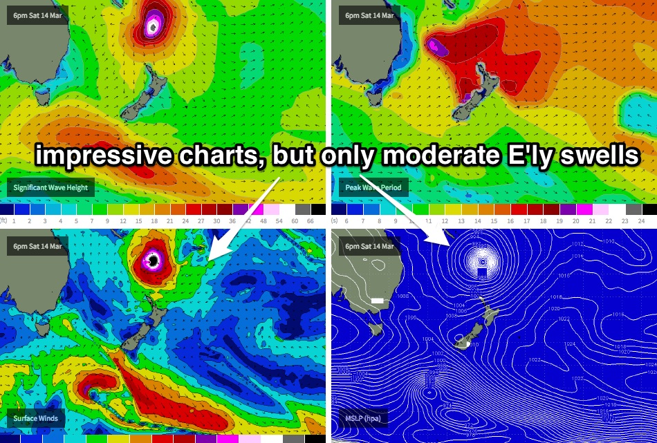
This weekend (Mar 14 - 15)
No major changes to the weekend forecast.
We’re essentially looking at a combination of trade swells from two sources: a pre-existing E’ly fetch that’s been slowly strengthening south of New Caledonia over the last few days (i.e. a continuation of the swell we saw today), plus a second short range SE swell from a building ridge through the Coral Sea.
Wave heights will be biggest in the north, with smaller surf with increasing southerly latitude. So, open beaches of the Sunshine Coast should see bumpy 3-4ft+ waves on Saturday, with 3ft+ surf across open Gold Coast beaches and then 2-3ft surf across Northern NSW. Expect slightly smaller waves across regional point breaks, depending on exposure.
Note: I’ve slightly pulled back wave height estimates since Wednesday due to the fetch in our eastern swell window being a little below Wednesday’s expectations, and the second ridge currently building through the Coral Sea doesn’t look quite as well positioned as previously modelled.
Most locations will be under the influence of the ridge on Saturday, which will cause gusty S/SE winds in general. Pockets of lighter SW winds are possible in a few areas early morning (i.e. Coolangatta). Sunday will see much lighter winds as the ridge weakens and the pressure gradient relaxes, however surf size will correspondingly dip a little in size from Saturday. So, expect fun morning beach breaks on Sunday.
Late Sunday may also herald the arrival of a stronger E’ly groundswell generated from the supporting ridge south of TC Pam (which is modelled to develop immediately S/SE of New Caledonia this evening). Most of this swell will fill in on Monday but the last few hours of Sunday may see strong stronger sets above the morning’s size estimates.
Next week (Mar 16 onwards)
The synoptic charts really do look quite amazing, when viewed in single frame time increments. TC Pam is at Cat 5 strength and incredibly, looks like it’ll maintain Cat 4 intensity down to about 30S (which I’ve never seen before).
Nevertheless, I still haven’t changed my thoughts from Wednesday’s notes: that is, TC Pam will move too quickly to the south-east to be able to generate a swell event worthy of the wind speeds around its core. We won’t see much, if any swell from TC Pam itself; all of the energy we see from Monday onwards will be generated by the supporting ridge to its south.
And even then, I’m a little concerned that perhaps all week I haven’t been conservative enough in my estimates. The swell period charts look incredible and it’s easy to get drawn into the hype of a major surf event, but I just don’t think the easterly fetch is sustained enough in any one region to generate any truly amazing groundswell. Certainly not of any notable size anyway: had TC Pam been forecast to track more much more slowly SE, we could have potentially doubled if not tripled these size estimates. Unfortunately its SE path perpendicular to the Great Circle paths diminishes our surf potential quite a bit.
Even the models have cooled on this event quite a bit (our surf forecast model that is), which on Wednesday was calling for a peak of 5ft on the Gold Coast, but has eased that back to 3ft.
But for what its worth, I’m going to hold steady with my estimates and only downgrade a small degree. I think we’ll see a building trend across most open beaches (in all regions) with Monday and Tuesday likely to see 3-5ft surf, and smaller waves on the points. Wave heights will then steadily ease from Wednesday onwards.
Monday’s winds will only favour the semi-exosed points anyway with another ridge building across the coast, driving fresh southerly winds to most regions (SW early), but this ridge will weaken overnight and Tuesday looks better with light morning winds and afternoon sea breezes.
In fact freshening NE winds are expected through Wednesday so you’ll have to surf early whilst winds are light and variable as it’ll become chop in most locations after lunchtime (only exception likely to be the northern most regions such as the Sunshine Coast).
Elsewhere, TC Nathan looks like it’ll remain outside of our swell window until the middle of next week at least, however there is still some potential in the long term as it possibly meanders from the Coral Sea through to the Tropical South Pacific. So don’t write it off just yet.
We’re also expecting the Long Wave Trough to cross the SE corner of the country later next week, so a southerly swell is likely at some point during next weekend.
Otherwise, it’ll be very interesting to see what eventuates in the surf department early next week - I’ll detail everything comprehensively in Monday’s updated notes.
Comments
As per the notes above, anyone seen a Cat 4 down to about 30S before? This is from Fiji Met this evening.
Not that I can think of... Dinah came close, but slammed into qld, losing intensity.... I'm sure it would've stayed at cat 4 if it had've headed se instead of giving Bundaberg a nice old touch up..... A reading of 944.8 was recorded as it hit land, but it didn't pass directly over a weather station, so its actual central pressure was not known.... Been a few cat 3's that have gone well beyond 30s, though... Susan made it to around 33/34s as cat 3.....
Cyclone gene actually intensified from cat 2 to cat 3 at 26/27s ( which is impressive on it's own), and remained cat 3 all the way to 36s... Quite a feat.....
Fine looking system holding strong.
Looks so much better on the charts could off been something special.
On the 6.3.15 -Prog. 13.3.15
Today SN 13.3.15 Real time Prog.....?
1 week ago :)
guys got a question for u, these maps look like to me as classic examples of giving eats cost swell as most swell swings off south side of system, is there anything i am missing, i know the systems moved so quick and east. but it they had sat, that would have been the epic scenario, am i reading this right? isobars look like wind direction was perfect as well- windstrength may have been an issue, but this would be one to put up on the wall or could u animate me one that u reckon would be better?
That's incredible for a long range cyclone model forecast! Almost perfectly forecast seven days out.
Fetch and "mini low" lining up east coast tassie looks better in the first one... :/
Yeah cool stuff Ben;)
And this is why I was confident on the call of no decent E'ly groundswell until around Tuesday back on the 5th of March or so.
I've remained fairly quiet on this storm, apart from some stats re' active sea state, which I still stand behind..... ATM, in the cyclones path, there is an ese long period swell below New Cal, which we chatted about here...
http://www.swellnet.com/reports/forecaster-notes/south-east-queensland-n...
Also, in the above thread, you'll notice a map posted by craig... Pam did not follow that model, and has in fact taken a more ssw path, therefore putting it slightly closer to Qld....
With these two factors in mind, plus the fact that it is a beast of a system, I'll go out on a limb (just to get people frothing and using up all their mojo hahaha)
I think 3 to 5 foot is a slight undercall.. perhaps it is best to err on the side of conservatism, though
But i'll go 4 to 5 foot.... Plus a 6 foot bomb or two, every 10 or so minutes, associated with that active sea state situation detailed in the link supplied.... Cheers....
When, what day Sheepio...?
I've missed all the action here the last week, hanging off a building painting in Brisvegas, favour for a mate. Big days. That traffic is absolutely shit still. No wonder I choose to work offshore;)
One more week at home so hopefully get a few more in before.
When you reckon Sheepio!
Ben's spot on with the times.... I've probably just gone up "one notch" on the size than he has, welly...
Got some serious stuff now entering seq/nnsw swell window at 172ish/22ish south
Feelings go out to those affected re' vanuatu etc...
Surely it,s time for an upgrade,3,4ft Your joking, there's gonna be more than that.Now the ascat,s showing wind in Our window who else wants to stick out there necks SD call 4-5ft could be an under call imo.
The forecast is 3-5ft, not 3-4ft SM.
I've been calling 4-5ft since last Friday; I slightly broadened the sizs range in Friday's notes (for all of the reasons listed above). In essence, I still think the cyclone is tracking too far quickly to the SE to generate much more size than that.
What do you call, SpiderM?
Whats the call for The Ultimate Waterman event in NZ ?
Considering the up to 4ft of trade swell We have today on the nth sunny Coast open beaches could be 4-6 on Monday.also strange how the Moolab. bouy has been showing swell just Nth of East for the last few days,whats that about?
yes the quikkie pro done and dusted and the waves arrive again, three cheers for HUEY, who knows surfing is an artform celebration not a comparison of competitive battle the decides winners and losers. There is no such thing as losing in surfing, so get out there welly and shred big fella .and enjoy yourselves- 3-4-5-6 foot, its going off, yeew
Wait for me, I'm coming!
Ohhh, no.... Not kumbaya dave!!!! How are ya, ya hairy reprobate!!!!! Big night mate?
BTW, you were a disgrace yesterday....... In front of the worlds cameras for all to see, carrying on like that.... Keep up the good work!!!!! ;p
spider, dunno re' ene..... But it's still gotta heap of east in it...
lite up the dance floor, nearly married a philipino beauty, swooned a very sexy english doctor, fell in love with one of the most gorgeous girls i have ever seen and told her so, chickened out to get her details- big sook i am-and then in had a bloke have a crack at me for sitting his chair,, but he soon backed down when i grabbed him by the throat and drove him back into the bar and would not let my grip off his adams apple .
then got saturated walking home. woke up at dawn still sitting upright on the lounge with my dinner plate in my lap- no staying power these days old rave.
All that with a crook neck??!!!!???? Fuck I'd hate to see you fit!!!!!
Never forget when I told back in 83, "hey Dave, we've paid for the tickets!!! 2 weeks at burleigh !!! For fucks sake mate, it's a dead game... You can't make the finals... All you could do id hurt yourself.... Pull out mate... Don't play!!"
But dave ignored the wise words of the dog... He went on to play that soccer game..... he broke his ankle in two places...... Jeff bought Daves ticket, and jeff and dog scored 2 weeks of great waves from 6 foot burleigh, 3 to 4 foot currumbin, surfed rainbow through greeny with rod rocket, and had epic dbah....
thanks for reminding me,
last night was always going to be my swan song mate,
in bed today, sore as buggery, pins and needles galore
I'll rest up then just get on treadmill and gentle swimming.
no regrets about you and jeff, he would never have taken that opportunity later on like you and me. some of his best memories i reckon- stoked for you both
good times the cove local boys.
i may have to move though as watching these beautiful coloured perfect waves breaking and not getting amongst it is really starting to cause anxiety.
Could be worse, dave.... Could be in tassie getting one surf a month if ya lucky.... A balmy 16 top temp here today..... Thank god tomorrow wont be as hot... 13' top temp they reckon.... Won't have to have the fan on....... :/
Anyways, back on topic.... Moolah' buoy at 2.4m??? Brisbane 3.4??? And Byron has a major "red blob" out of the south.....
http://new.mhl.nsw.gov.au/data/realtime/wave/Station-byronbay
NNSW SEQ , solid 5 foot ene pulse for late monday maybe???
That's been mentioned in the notes from last week - Mon, Wed and Fri.
Yeah, been keeping track..... Just dunno about the downgrade to "3 to 5 foot"..... I think having a system potentially remain cat4 till 30s ( as you pointed out - still can't find btw) will be a good scientific study re' swell.....
And a thought for everyone........... At least 6 people confirmed dead... The death toll will rise no doubt..... So, when you rock up to the beach monday/tue/ wed, and you see the waves rolling in, spare a thought thru the stoke, for those that perished in the storm that helped create the waves you are about to ride..... I don't wanna get too "guru like", but be humble, be kind, and acknowledge the call of the Tapae......
It's only a minor downgrade - I had 4-5ft from last Friday through Monday and Wednesday's forecast (so, my call has been super consistent) but when I prepared Friday's notes the wave models had majorly downgraded this swell (as I wrote above) so I just wanted to give myself a little elasticity.
My point here being is that some forecasters purely work off the automated numbers (from computer models) but I don't do that at all. I've gone against all model guidance to keep my forecast at 3-5ft.
And that's why I respect you, Ben :)
She's one nasty storm, buddy..... Just saw news footage of vanuatu... Poor buggers...
I don't think i can recall a system like this one..... So as the blind man says, "we'll see"....... My gut still says freak 6 foot bombs every 7 to 10 minutes, only due to that long distance swell in the mix which we spoke about earlier in the week....... Cheers, man.....
Like the sound off that. how is the wind looking for Monday/ Tuesday ?
Been watching the BOM forecasts for this swell event. In particular there is once again a major difference between BOM's Byron Coast and Gold Coast forecasts (check the direction on Monday):
For Monday:
Byron Coastal Waters Forecast: Point Danger to Wooli (issued 4pm today):
Swell: Easterly 1 to 1.5 metres, increasing to 1.5 to 2 metres south of Yamba around midday. (note, they added in the 'south of Yamba' part this afternoon; this morning they had 1-2m E'ly swell all day across the whole region).
Gold Coast Waters Forecast: Cape Moreton to Point Danger (issued 4pm today):
Swell: Southerly 1.5 to 2.5 metres.
Sunshine Coast Waters Forecast: Double Island Point to Cape Moreton (issued 4pm today):
Swell: Southerly 1 to 1.5 metres, increasing to 1 to 2 metres during the morning, then tending south to southeasterly 2 to 2.5 metres around midday.
For Tuesday:
Byron Coastal Waters Forecast: Point Danger to Wooli (issued 4pm today):
Swell: South to southeasterly 1.5 to 2 metres, tending east to southeasterly 1.5 metres during the morning.
Gold Coast Waters Forecast: Cape Moreton to Point Danger (issued 4pm today):
Swell: Southeasterly 2 to 3 metres.
Sunshine Coast Waters Forecast: Double Island Point to Cape Moreton (issued 4pm today):
Swell: Southeasterly 1.5 to 2 metres, increasing to 2 to 3 metres during the afternoon.
And this is why boaties and people drown.....
One nasty storm where we will see jack shit of it.
What a shame;)
Bring it on. Batteries charges & cards ready!
ben, not going to put you up on the kirra eagle if your wrong,, but how big do u think it will get and what part of coast will get best swell. others can come in with there opinions too, but its not a contest, i would just like to know where the swell will arrive and produce the best waves to surf It was a serious but funny unique track this system tracked and im just interested how its wave energy will impact the Australian coastline.
these long range things usually no good for noosa? granites? take off 2 feet? so every man women and child to Kirra or does the sunny hoax have a hope?
Crikey.
I'm going to review the forecast data in detail this afternoon (once we get the next pass in a few hours).
Have a look at the Descending Pass Ben. That thing has motored off to the S/SE at lightning speed so it's hard to get excited by a single image.
I know (and that's what's always been expected - been waiting for that image all morning!).
However I have NEVER seen a fetch like that north of about 35S before. So, I think there's possibly some wriggle room in there for a possible size upgrade. I'll try to create an animation to help process these thoughts. Just gotta crunch the numbers again.
Upgrade ???
Solid 5 to 6?
my gut still says solid 6 foot sets, Cyl85..... Mainly in the first 24 hours of the swell..... Then a very steady tailing off...... I think it's gonna be a bit like a big hobart swell - BANG it's pumping..... Bang it's gone...... Let's hope the peak isn't overnight monday/tues...
Any chance there will be a slight bit of northeast in this swell across the sunny coast, some of the charts are showing this
is anyone going to acknowledge the fact that the Nth Isle of NZ is going to cop a serious swipe from this system . And more so a trailing SW wind after its passed to really open options to the residual NNE Swell ..... could be exceptionally epic . Mick ? I presume you've flown home . Welly ?
Had a "private" chat with a certain chap, southey.... a rare NZ east coast right with a very small north swell window will be the go.......
Yeah was thinking of going back for Monday - Wednesday to one of my favourite haunts SE North Isle.
I have to go back to work Sunday so will give her a pass.
SN's surf forecast are a little weird for that part of the country, SW swell first up ....? I would of thought a ENE swell pretty solid the turning more SE swell, which still pumps at this place.
Any hoooow all good. Watching this system and will get reports from people back home;)
SW swell? On Monday, for Whakatane, our models have a N/NW swell (4.7m @ 18 seconds), an E/NE swell (4.6m @ 11.9 seconds) and an E/SE swell (5.2m @ 10 seconds). Perhaps you're seeing the SW arrows on the graph for late Mon/Tues (which are wind direction).
IMO, the models are struggling to resolve the swell trains properly - I think it'll be signifcantly bigger than 10-12ft at exposed north facing coasts.
Yeah we've been privately acknowledging it in the office :D
In fact, we've been trying to organise at trip over there (with a team of surfers/photogs) ever since this system popped up on the long term charts, but the logistics didn't happen. And not just this particular spot too - there are a number of other options that would have seen incredible waves from TC Pam.
All good Ben but not Whakatane ways;)
Wams look good for where I was looking at with more so ENE swell but surf forecast is saying SSW swell Tora ways....?
I do see what the projection outlays and these type of systems end up similar but with ENE swell moving more so the SE-SSE direction like you have said.
It looks like its moving quickly on the WAMS but coming from so far North with a bulldozer push lol, sure there has to be more East swell to start with then going SE -SSE.....?
Cheers.
Love the input Ben:)
Hi Ben,i got the 3-4ft off the wams forcast on this site.Their still showing 3-4ft!any reason it's not picking it up?same reason BOM is failing to see it I suppose,although Bom always seem to not capture ground swells.Sometimes I think BOM are way short staffed.
Models aren't picking it up because of all of the reasons I mentioned in my detailed notes above. The cyclone simply tracks too quickly SE through the swell window.
There's no way for us to automate a way to fix the model data. However my notes (above) will try and correct any of the problems (that I see) within the model data.
Does anyone think we may get a bit of a jack in swell this afternoon . ?
Yeah, but not directly from pam....
Yep and 4-6 with random 8fters tmoro arvo and tue a.m. from Pam
I'm with you Boo Boo, good call Ud's
thanks sheepdog. Hoping it hangs around till tuesday morning
Ben wrote; "Late Sunday may also herald the arrival of a stronger E’ly groundswell generated from the supporting ridge south of TC Pam (which is modelled to develop immediately S/SE of New Caledonia this evening). Most of this swell will fill in on Monday but the LAST FEW HOURS OF SUNDAY may see strong stronger sets above the morning’s size estimates."
Tweed picking up a spike in size and period now.... 10 seconds........
http://www.qld.gov.au/environment/coasts-waterways/beach/waves-sites/twe...
Swell looks like its up a bit on the Burleigh cam
Yeah... and all qld buoys except for Brisbane are showing signs of 10 second period......
Felt like that this morning, swell coming from a long way away, Soild 4ft on the beachies with long periods , Probably bigger in some magnets for sure.......!
Building
Lets see tomorrow!
Late tomorrow, welly..... I'd suggest *********, cos the sand looks shit at ********..... Just don't get ya shit stolen on the beach........
SurfLock Sheepio, all good..
Surfed mount maunganui main beach nz tonight but was still only 3 foot. Going hunting a couple of mysto spots tomorrow though if it gets as big as it's meant to.
Been renovating can't go but half of Hawaii are in NZ. Windy though be pockets of gold.
Love the chat re nz....would be great to see. Interested to hear how rare this type of swell direction and size is for the north east facing coast? I'm sure there will be mystic spots breaking everywhere?!
Shot from somewhere in NZ by Peter Perreux
The photo I posted yesterday of NZ..... mick knows the spot, craig...... All time rh reef inside a headland..... Off it's nutter today, with a wind comparable to a stiff southerly at kirra......
Ah just saw that, looks sweet!
Groundswell has just hit, you can see it on the cams and it's registering on the Tweed Buoy now.
Also you can see both swells in the water, with the image below showing the new groundswell (red) mixed in with the lower period trade-swell (green) creating weird double ups.
Just saw a real solid set on snapper cam..... Somewhere around the 10.58 to 11.00 am mark, craig.....
2 more bombs at 11.06/7...... lets see if the old "6 foot bombs every 7 to 10 minutes" holds true.....
Yep..... Big wide set down a rainbow 11.14..... Another on the rock 11.23....Set your watches lol....
Crowdy and Sydney buoys picking up a faint E/NE groundswell signal to 19s.
Definite 7 minute set pulse.... The odd sneaky 5 minute set.... Sometimes blowing out to 9 minutes..... But 7 minute ish ave..... Seen enough.... Getting pissed off.... A- not there... B - the crowd....
lots of smaller nice ones between sets.....
at work watching the cam what a bitch.. good early call sheepdog
Haven't seen anything in the 6ft range yet (on the Snapper surfcam). Might be at a few bombs at the swell magnets in Northern NSW but right now the Gold Coast call looks pretty good, with strong lines in the 4-5ft range.
Seen a couple, ben..... A behind the rock set at 10.58 - 1100amish automatically comes to mind if by chance you can access that... A big stand up barrel behind the rock at 1252ish, a face plant at 12.20ish...
A couple touch and go there, Ben..... When do you think it will peak?
And the time on the snapper video..... Is that qld time or or daylight saving time?
Nothing near 6ft there SD, I reckon. Good strong 4-5ft sets though and as I said before, wouldn't be surprised if there were bombs down the coast.
[times are local on all cams.. ie that's Qld time]
I have no idea when it'll peak. The system was too complex to accurately hindcast and without a disant wave buoy, it's educated guesswork based on model data and manual calculations as the the current phase of the swell.
I'll review the data in a few hours time though and give it my best.
Undersized at Noosa nice 4fters granite hope there's more to come. Good looking swell tho
Moolollaba buoy hasn't picked up the groundswell that the Gold Coast has, the system was better aimed to the south though, did you any groundswell in the water SM or was it a continuation of trade-swell.
[times are local on all cams.. ie that's Qld time]
Then that explains everything, Ben....... Didn't look like the footage I watched at 11.00am, but I'm in Tassie, and i was going by my computer time..... Daylight saving time.....
Also note that the footage you posted was right on the change of tide, being 11.00AM, which explains the lullish 10 minutes.... had a laugh at that guy at 8.43 though....
"Also note that the footage you posted was right on the change of tide, being 11.00AM, which explains the lullish 10 minutes"
Oh, c'mon SD! Really?
Sheepy, you do realise that the most movement between high and low tide or vice versa is mid-way through the change, ie at low or at high there is very little movement at all to influence the waves/set consistency.
come on boys being to picky the sun out its a groundswell we rarely get and water is warm beats working
Exactly :D
Jeez...
All I said was I saw a few 6 footers in the mix WHILST USING DAYLIGHT SAVING TIME... But we'll forget about that, shall we lol.....
I didn't start the debate... And we all know things can get a bit dodgy at the change of tides.. Maybe "lullish" is the wrong word to use.... "Dodgy" may be better.... Still saw a couple in that video above on the 5 foot "plus" sale.... 3.49, and 7.28....... 7.28 is a pretty solid drop.......
Anyways, Be interesting to read your thoughts on the 10.58am -11.00am "ish" daylight time, which is 9.58 -10am qld time ;)
Cyl85...... I'm sitting in a cold tassie country house.... And I'm over it...... ;) Catch one for me bro.......49
Was down that ways at 11.30am probably good solid 4ft nothing bigger.
Counted 573 people in the water from Btm Greenmount to Snapper with probably 60-70 at Kirra, good looking waves.
But it never got the 574th....;)
Circus parade.
Burleigh was way bigger.
Should keep that photo of my arse smacked by my wife:)
573! I'm impressed. I would have given up counting at 73.
Yeah I kinda do that often, just to let me know how many people are out there and is it worth going for a surf just to get really annoyed.
Which has happened many a time in the past.
I like Snapper to Greeny on stormy, raw un even swells, when the low is sitting just off the coast raining it tits off, plenty of waves for every one and lots of sections to disperse the continuous ride.
Ben thats 3ft-4ft and 150 people, haha
lol.... It's touch and go... I could pull out my maxwell smart voice and ask "would you believe 5 and 2/3s feet with 6 inch side chop" lol..... Another stand up barrel I must've missed at the 1.20 mark.... With a mung bean drop in to boot....
Well I've just gotten out of the surf at a north facing beach and I can tell you the swell is underwhelming. But we still got some uncrowded fun ones. Just a shame that swell is smaller (less NE in direction) than I was expecting.
Craig,for sure groundswell in there,just really inconsistent,Granite showing the best of it but nice small lines further in as well.great for the loggers,Alex Knost,hynd.Ryan Burch,whole bunch of hipsters and gurus catching great waves at nationals.probaly better watching than surfing.
Spider... I heard on the grapevine that this morning before the wind got up, a certain few beachys/ coves, and a "secret heavy right" at a certain place south of Noosa were firing.... Didn't happen to get down that way early?
geez cold down there sheep dog. Only bit off warm you get down there is the piss in your wetsuit haha. was thinking about getting the ferry over to the island a point over there that like a E Ne swell any thoughts ?? swell going to be around tomorrow?
Swell easing and swinging more E/SE Cylinders, don't like your chances for anything big or epic.
thanks Craig any thing to beat the crowds. I've had some epic uncrowded session's over there.
Yeah, like craig said, I reckon she's gonna drop out quick tomorrow arvo, cyl.... I reckon most of the stuff today and tonight was from that burst of energy tucked in behind new cal ( see earlier ascat images in thread... Still reckon there'll be some good ones really early..... A couple of asact images sorta predict a peak tonight.... But this has been one heck of a system to get one's head around.... That ascat image Ben posted on page 2 I think, was unbelievable....
Wherever you end up cyl, do it super early..... Winds look dodgy for tomorrow arvo
---- nah it was page one......
cheers no risk no reward i am thinking.
Juggling a few things right now but should have the updated forecast up around 7pm Qld time. Sorry for the delay.
Ohh, btw, cyl, Yeah so over it down here...... Nothing against the people... They are fuckn awesome.... Even the graffitti artist, who by the way got me a beauty - If you're reading buddy, that was fuckn funny AS!!!! You win mate, hats off to you :)
But tassie is a young mans surfing paradise.... Lots of effort, travel, cold.... Real commitment needed down here.... Might be heading back to the mainland, not qld, though ( as certain folk breathe a sigh of relief lol)..... Anyways, cyl, catch one for me, champ... Cheers......
"Even the graffitti artist, who by the way got me a beauty - If you're reading buddy, that was fuckn funny AS!!!! You win mate, hats off to you :)"
What did your best mate write on that seat Sheepio............;)
I'm sure Davo the Ravo never flew down that ways....!
Not today SD surfed down there yesterday was alright.check the late spike in period now on the mooloolabah bouy,mabe that was the longer distance trade swell today and cyclone swell hitting right now
What were the scratchings champ..
It was looking good this morning at Rainbow but ended up being very average.
Dbah was actually pretty good this arvo.
OK latest forecast now up!
https://www.swellnet.com/reports/forecaster-notes/south-east-queensland-northern-new-south-wales/2015/03/16/great-waves
hey mate what time will Qld/Nsw report be up thats Sydney thanks
My bad.. had wrong link! Been a looong day...
no worries thanks for that .
Had some great waves today in the hauraki gulf nz but just about every surfer in auk was on it too. All the town spots were firing but the coro coast was maxing out but a couple of places were unreal. The whole coromandel will be mental tomorrow if it doesn't drop too quick.
great forecast thread.
http://earth.nullschool.net/#current/wind/surface/level/orthographic=-18...
nice view of Pam.
surfed 3-4 foot Kirra tonight till dark. SD you are on after school detention.
Reports NZ Coromandel best day ever though so it will be just a warning from the headmaster
Be very careful, headmaster free...... Or at morning school parade, I'll blurt out to everyone where that righthander is....... ;)
i love that null school site. it really shows the wing patterns and swell creations.