Lotsa small, long range east swell on the way

South East Queensland and Northern New South Wales Surf Forecast by Ben Matson (issued Monday 22nd December)
Best Days: Thurs onwards: building east swell, you'll just have to work around the local winds. Sat/Sun/Mon: chance for a local SE swell for the SE Qld semi-exposed points.
Recap: Small combo of south swell and south-east windswell over the weekend, but hardly worth the effort with mainly onshore winds. Small residual swell today with early light winds tending onshore and freshening during the day.
This week (Dec 23 - 26)
Not a great deal to get excited about in the short term, but we will certainly see an improvement over the last few days.
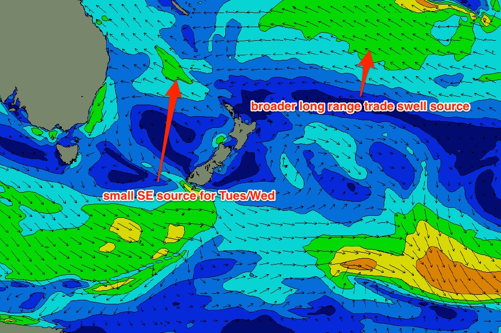
Right now we’ve got two active sources of swell generation for our coast. A modest ridge across the central/northern Tasman Sea is showing ~20kt SE winds aimed into the Coral Sea (see below). This fetch won’t last very long but should kick up a small SE swell for the region, arriving through Tuesday and easing later Wednesday.
Also hitting our shores on Tuesday is a small, distant east swell generated by a broad, slow moving band of tradewinds that developed north and north-east of New Zealand over the weekend.
Initially, there won’t be much size from it: probably some inconsistent 2ft+ sets at open beaches from about Tuesday afternoon onwards, with long breaks between waves (expect smaller surf Tuesday morning). The morning’s light winds will give way to an afternoon sea breeze so it’s hard to get too excited right now.
Wednesday will see light winds in most areas for much of the day owing to a weak pressure gradient (freshening nor’easter are likely south of Coffs though), and the early session should still have intermittent pulses of this swell combo on hand. It won’t be very strong nor sizeable but if you’ve got a high volume board there could be a few little waves about the traps.
Late in the day, we may see the leading edge of a second, stronger pulse of easterly swell generated by the stationary trade belt in the South Pacific. This is expected to be the beginning of an extended period of distant east swell (as I’ve been discussing since last Monday) and wave heights should nudge up into the 2-3ft+ range throughout Thursday (Christmas Day) - possibly a little undersized early but well and truly into fifth gear by the afternoon.
Freshening NE winds are expected during Thursday afternoon (following a period of light, variable winds early) but they’ll be a little weaker in Far Northern NSW and SE Qld, so hopefully conditions will remain OK for an afternoon session in these areas.
This east swell is then forecast to ebb and flow within this size range through Friday with winds holding from the northern quadrant (lighter early, probably NW).
We do have a southerly change expected to push along the Southern NSW coast during the day (of which its timing is not yet clear) so this may throw a few curveballs for local winds - especially across the Mid North Coast - but there’s a reasonable amount of certainty on the swell front, which is encouraging. I’ll fine tune the forecast for the second half of the week on Wednesday.
This weekend (Dec 27 - 28)
The aforementioned trade swell will continue to supply our region with inconsistent but reliable easterly energy through the weekend and beyond, within a similar size range as per the end of the week.
Also on the charts is a possible trough in the lower Coral Sea, pushing up against a ridge in the wake of Friday’s late southerly change across the North Coast. Although there’s no general consensus across the broader models, such a development is certainly not out of place for this time of year.
If this scenario occurs we could be looking at a reasonable short range SE event with gusty S/SE winds building Saturday and holding into Sunday, suitable for the semi-exposed points in SE Qld. I’ll have more on the chances of this in Wednesday’s updates.
Long term (Dec 29 onwards)
Aside from the stationary trade belt in the South Pacific - which looks like it’ll hang around in some form for the next couple of weeks - there are no significant weather systems on the long term charts. I’ll take a closer look at the long term outlook on Wednesday.
Comments
Hmmmmm interesting times ahead as the MJO approaches over the coming 10 days +
Forecasts are still moving around on its strength and movement but ECMWF and BOM have it moving through in that period but without too much strength.
For those wanting an explanation of the below charts, read this https://www.swellnet.com/news/swellnet-dispatch/2012/03/15/cyclone-prosp...
EC:
BOM
Looks like TD03F will probably develop into a (brief) Tropical Cyclone way out near the Cook Islands over the coming days.
Certainly won't be a swell producer for us though.
Shall I, Ben????.... nah, forget it.... ;)
Huh?
Cyclone swell feed into the fetch off the top of the high ?
Well, udo, Ben... Been watching that region since here;
http://www.swellnet.com/reports/forecaster-notes/south-east-queensland-n...
two areas of interest, one near Fiji, and one right on the "rectangle" line near 170'...... That's the low Ben has highlighted..
The almost permanent high east of NZ has all the characteristics of a perfect cradle.... Since I have been waffling here ( early 2014), I have noted that swell from this region are ever so slightly under called.... If this low slips into the vicinity of 20s or below x 170 to 160w, and the high remains as most charts have it, This low will have an effect swell wise......
Look, I don't want to get into a pissing competition - but I first mentioned that region (as a source of "long-lasting distant E’ly swell") four days earlier than that (Monday 15th):
"Broad trades developing north and north-east of New Zealand from this weekend signal a return to small but long-lasting distant E’ly swell for the foreseeable future (beginning early-mid next week, that is)."
Nevertheless, this TD (or TC, if it develops) will definitely not be a source of swell for us. The TC may briefly be attached to the tail end of a broader trade flow (that will provide us with small long range east swell) but the TC itself will not generate any swell.. i.e we won't see any 15+ second energy at any East Coast Australian buoys.
I'm in no pissing competition.... You mentioned broad trades..... I mentioned the development of a tropical low.... Two totally different things.... Still looking very bare for the foreseeable future in the New Guinea/Solomans/ Vanuatu region...... Cheers....
Fair point, I stand corrected. I was more referencing the phrase that you've "Been watching that region since here" - that region had already been on watch for many days.
However I stand by my earlier claim - this system won't be a swell producer for us, unless the models change course in a significant way. Right now it's positioned a very large distance from the mainland - the only systems that produce swell for us from here are either broad, stationary TDs or TCs (with core wind speeds in the order of 50-60kts), or massively amplified trade belts.
I'm always on watch out there, Mr Button...... 1st mate -itis.. Old habits die hard..... Anyway, some models have the low holding it's intensity and being cradled in a similar position to a couple of long distance swells the came from the region earlier this year.... A few models have it losing all oomph, and drifting se into nothingness...... It's a 50/50 gamble at the mo'..... Not willing to take the punt, but eyes are open...
My gut says watch the solomans and the Gulf of Carpentaria post Jan 1st...... Nothing in the short term......We are nearly due for a system to form in the gulf, move east across the cape, and reform in the coral sea...... No scientific facts to back me up..... It's just we're due..... And the Solomans seem to be a decent producer of systems over the past few seasons.... I can't see that changing.....
Agreed - the Solomons is a great breeding ground. And yep, we're well overdue.
I'll remember how to spell solomans, I mean Solomons one day lol
boys, even though the MJO shows signs of becoming more vibrant, what's your take on the monsoon trough, it doesnt appear to be as active yet, i admit i have not looked at any data that may show it to be further north, but talked to boys from darwin yesterday and they say even old timers saying this year a bit strange. as said, i havent studied much data, ben, craig, don, mitch- whats your call at this stage- small wet or late one or one dry but wet with cyclones?
The Monsoon Trough is influenced significantly by the MJO and I'm not totally across the dynamics up around Darwin, but we haven't really had a strong phase of the MJO move through as of yet, and this may be the result of the reduced activity.
These notes are always good to reach every week.. http://www.bom.gov.au/climate/tropnote/tropnote.shtml
thanks craig, good one, for some reason my puter freezes on certain bom pages so i got over it, but good info, cheers
Cheers for keeping me in mind JB but out of my experience
Had an interesting experience tonight, on the eve of my 48th birthday. I would love all to visualise, low pressure so we get waves, think of great images of snapper, greenie, kirra, out there i know, but it would blow this yanks mind but get me in this dutch goddess real good books. fuck its pumping. lets get it happening swellnutters
48.......48......... Happy birthday, Jimmy.... Kumbaya to ya you old hippy!!!!!! ;)
thanks brother, loving life and life is loving me, may jimmy bodysurf forever just like the Captain and Astro and the Sunnyboys- merry christmas tassie devil, may santa be kind to you
Mate, you'll have to try to get down here before we sell up.....
The follow up system to TD03F looks better for cradling/swell production IMO. A long way from the east coast but still a swell producer.
boys, will this little north carolina yank mate get anything decent from snapper in the bay, or d-bah or tweed coast better option. he is leaving sunday/monday. Will also give me some cred with this dutch goddess if waves turn up.