Small directional south swells with gusty offshore winds

Southeast Queensland and Northern New South Wales by Ben Matson (issued Wednesday 25th June)
Best Days: No great days in SE Qld. Otherwise, Thurs/Fri: small south swell early at exposed beaches in Northern NSW, with gusty offshore winds. Mon/Tues/Wed: plenty of reasonably strong south swell, with gusty SW winds.
Recap: Tiny waves both days. A small new south swell should be starting to show in the Lower Mid North late Wednesday afternoon.
Next week (June 24-27)
Just to kick off these notes in the same vein as Monday’s - SE Qld surfers are looking at another week or more of tiny to flat conditions at best. So if you’re unable to consider a road trip south of the border (where there should be some fun waves), then you might as well stop reading here.
Moving right along… when the dominant swell direction is from the south, it’s always worthwhile keeping an eye on forecasts, reports and obs from southern NSW because this will give a good heads up as to what’s potentially on the way for Northern NSW the next day.
Right now, there’s a few interesting things happening in the Sydney region - a small, acute south swell is pushing into the region which seems to have capped out around 2ft+ at most open south facing beaches (but tiny to flat everywhere else, which is 80% of the region). However Bondi - one of Sydney’s better south swell magnets - was pulling in strong, consistent 3ft+ sets this afternoon. This is quite astonishing given that the primary swell source was a gale force W’ly tending W/SW fetch existing eastern Bass Strait. But, the surfcam doesn't lie.
This creates quite a predicament for the short term forecast period in Northern NSW. Should we factor in Bondi’s bigger-than-expected size, and correspondingly boost wave heights across Northern NSW? Because the swell pushed through mid-afternoon, it’s hard to ascertain whether it was a local effect or not (because surfcam observations from Newcastle - an even better south swell magnet than Bondi - were of the same size, if a touch smaller - I would have expected even more size here).
However I’m inclined to leave things as they are because all of the other observations across the southern NSW coast came close to forecast expectations - Bondi’s bigger waves seemed to be somewhat of an outlier. That being said, the current forecast period is extremely complex and confidence is not particularly high over the next few days, owing to this very flukey source of swell.
So moving on to the specifics: the current south swell in southern NSW isn’t very well aimed for Northern NSW either but it will build across the region overnight and further into Thursday. In general, most beaches will remain tiny to flat however a handful of south facing beaches may pick up a few stray 2ft+ sets. Conditions will be clean with moderate to fresh winds from the western quadrant.
Another pulse of similar acute south swell is then due to push through the southern NSW coast later Thursday that’s on track to deliver a similar level of south swell for Northern NSW on Friday (there may be a slight lag on this swell in the Far North). Set waves should approach 2ft+ at exposed south swell magnets but as per usual it’ll be tiny to flat elsewhere due to the swell direction.
Winds are likely to be moderate to fresh W’ly early but will veer NW then N’ly through the day as a high pressure system develops in the Northern Tasman Sea and a deep low (another one!) approaches Bass Strait from the west. So, the afternoon may become bumpy at exposed beaches but south swell magnets with protection from these northerly winds should fare well all day, even as the swell slowly subsides into the afternoon.
This weekend (June 28-29)
The weekend’s not looking too flash overall. Friday’s small south swell will trend downwards quickly during Saturday and further into Sunday, so most beaches will remain tiny to flat and even south swell magnets will be borderline surfable by Saturday afternoon. Gusty NW winds will strengthen and swing W’ly as the low pushes across Bass Strait. So hit up exposed south facing beaches early on Saturday for the best waves and keep your expectations low. I’ll reevaluate this on Friday.
Next week (June 30 onwards)
A similar weather pattern is expected to develop across the SE corner of the country from Sunday onwards, as to what we’ve seen this week.
However this time around we’ll probably be on the backside of the Long Wave Trough, which means we’ll see a stronger, longer and broader southerly fetch developing east of Tasmania - which should generate a bigger south swell for the entire East Coast early next week (except for SE Qld, sorry!) - in fact current guidance suggests we’ll be looking at moderate but punchy south swell from Monday right through Tuesday, Wednesday and maybe even Thursday (ballpark peak around3-5ft south facing beaches).
The only downside is that winds will be more SW in direction, and may even veer S/SW or S’ly at times - which will render exposed beaches a little bumpy at times. Still, there’s no shortage of southerly swell on target for next week. I’ll fine tune the specifics on Friday.
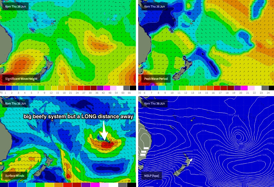
As a side note, how's the South Pacific synoptic chart for the next few days? (see below) A big, beefy and unseasonable sub tropical low is expected to deepen south of about Tahiti, displaying an impressive 40-45kt E'ly fetch aimed (briefly) towards the SE Qld coast. Unfortunately, it's an extremely large distance away - too far to be of any use to us - and the low will only be aimed within our swell window for a brief time. Still, Queensland surfers can dream... (we might see a couple of small waves out of the east sometime around next Thurs from this source, but I'll be surprised if there's much more than a couple of feet at best, with up to twenty minutes between sets).
Comments
Actually a few select NNSW swell magnets and spots exposed to S swell were considerably bigger than forecast today due to the axis of refraction effect.
Simply put there was more available room for components of that W/SW fetch to refract back into parts of the NENSW coastline.
It's quite noticeable especially when W/SW fetches exit the southern NSW coast during strong frontal episodes.
anyway, it was a nice treat for those who ignored the report and looked at the conditions.
Fr 76, I would've thought that the axis of refraction effect (on its own) is only noticeable on a local scale, when close to the axis (Vic/NSW border). Once it's getting up to NNSW, wouldn't the refraction be in the order of change in 1deg/10s of kms? I would've thought that difference in size is mostly due to local bathymetry, perhaps it even compunds the axis effect on top of the regular swell magnet effects?
Some pretty damn impressive refraction even into the SC last night! Wave buoy registering more swell than the Gold Coast!
It's an optical illusion don :p, The plot is starting from so low.
Yeah but it was twice the size of the goldy buoy.
yeah the southport one. Mbah being bigger than Southport on a sth swell is unusual, but I glossed over that as the Tweed and Pt Lookout buoys were bigger. So you think this particular case could be due to refraction, skipping the Southport buoy but hitting the Mbah buoy?
That's all I can put it down too, and again the further north/axis of refraction theory postulated by Steve.