Small southerly swells to domainte

Southeast Queensland and Northern New South Wales Surf Forecast by Ben Matson (issued Monday 23rd June)
Best Days: Thurs: small south swell at exposed beaches with gusty offshore winds. Fri: stronger south swell with gusty offshore winds. Sun: strong south swell building, with gusty offshore winds.
Recap: Fun south swells persisted over the weekend and into this morning, favouring exposed south swell magnets in Northern NSW but doing very little north of the border.
Next week (June 24-27)
Let me preface these forecast notes by saying that SE Qld is on target for an extended run of tiny to flat conditions. Apart from exposed south swell magnets - which will pick up small pulses of acute southerly swell at times later this week and through the weekend - most beaches on the Gold and Sunshine Coasts will remain tiny for quite some time. There's a small belt of trades slowly strengthening way out between New Zealand and Fiji at the moment but it's not particularly strong, and will essentially track slowly to the east over the coming days (which reduces the chances for anything worthwhile from this source).
Now that we’ve got that out the way, let’s discuss the Northern NSW region as there are some fun southerly swells expected later this week that should deliver good waves at south swell magnets. However there won’t be much surf away from these locations due to the acute southerly swell direction.
As per the synoptic charts, we’ve got a windy period ahead for the entire SE region of Australia in conjunction with a major cold outbreak. These winds will be strongest in the southern parts of the state however some regions of the North Coast will see gusty conditions at times. In fact a renewal of windy conditions are expected from Friday onwards (following a brief easing trend Thursday) that are more likely to affect the North Coast.
What’s interesting about this weather progression is its northern extent. The storm track is expected to be positioned either at Tasmanian latitudes, or across the eastern states, and this will result in two key factors for NSW’s surf potential - local winds will generally remain out of the western quadrant, and the swell window will initially extend only as far south as eastern Bass Strait. Later in the week we’ll see a fetch develop off the southern coast of Tasmania but this will still be quite constricted compared to what we usually see in this neck of the woods.
So, with the waters of eastern Bass Strait (and surrounds) being our primary swell source for the short term, we’re going to have to closely analyse the wind field across this region. Reason being - we usually need (as a bare minimum) at least a small degree of south in the westerly airstream for their to be any surf potential. In my experience there’s a very fine line where these flukey swells actually make landfall in southern NSW, and more times often than not, it’s just a couple of degrees in the swell direction that can make the difference between fun waves at exposed south swell magnets and total flatness.
So on to the specifics. Strong W/NW winds today and tomorrow will result in Tuesday and Wednesday being small, trending tiny to flat across most North Coast beaches - the only energy in the water will be a small level of residual swell from today, plus some tiny, infrequent SE groundswell generated well to the south-east of New Zealand late last week (discussed in previous forecast notes, but generally dismissed as a source of quality surf).
A front crossing the South Coast late Tuesday may temporarily develop a W/SW fetch inside our acute southern swell window but this is expected to last for just a brief time, so I’m not expecting much surf to develop on Wednesday (maybe a foot or so at a handful of super south swell magnets across the Lower Mid North Coast if we're lucky).
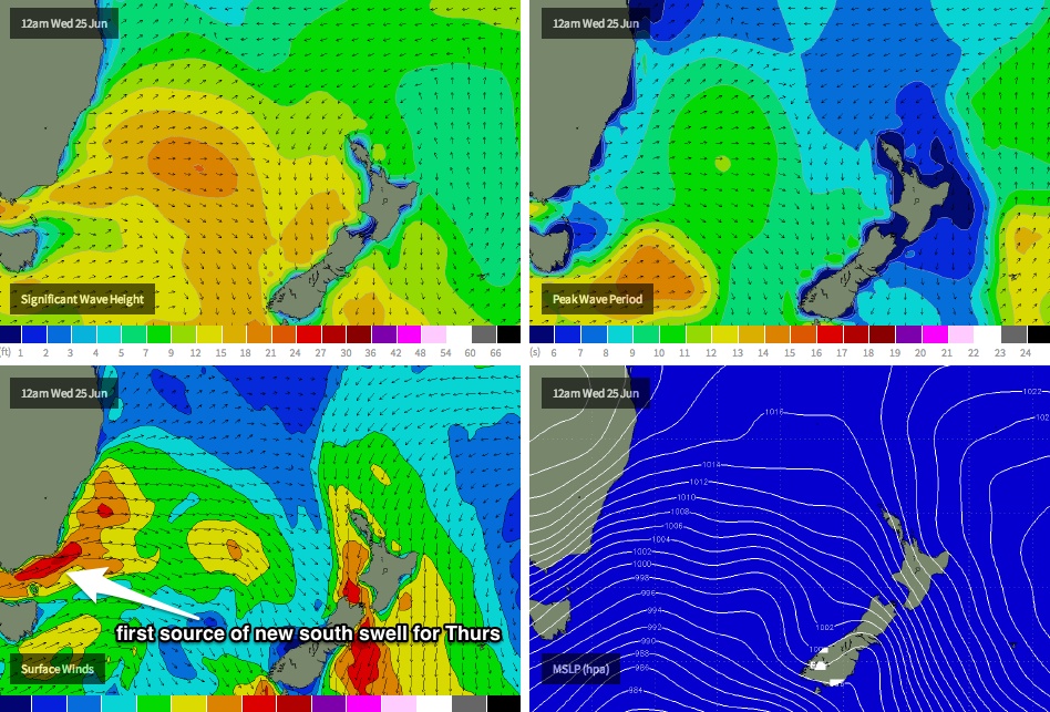
However a stronger, slightly longer lasting W/SW fetch is modelled to develop in eastern Bass Strait early Wednesday (see chart below) and this is probably our first stab at a reasonable pulse of south swell - I don’t think it’ll arrive until very late in the day on Wednesday at the earliest (and mainly only in southern NSW), with Thursday likely to see the most size in Nortahead of a slow easing trend throughout the day.
Size wise, south facing beaches may pick up a few stray 2ft+ sets, however beaches not open to the south will remain tiny to flat. Conditions will be clean with moderate to fresh offshore winds.
On Thursday, a much more significant front - this time extending just south of Tasmania - will push into our acute south swell window, and is expected to generate a stronger southerly swell for Friday. This energy is expected to reach the Mid North Coast in the morning, and the Far North Coast in the afternoon, and should generate 2-3ft+ waves at exposed south facing beaches (tiny elsewhere). Light NW winds will strengthen throughout the day. So right now, Friday would be the pick of the forecast period but we'll nail down the specifics on Wednesday.
One thing to keep in mind though - the models have been moving the specifics of these storms around in recent model runs, and it’s hard to get a gauge on whether they’re locked in right now, as small changes could push each of these small pulses around by a half day, and also increase or decrease their size potential (due to their close source). So let’s take a look in more detail on Wednesday.
And for surfers in SE Qld unable to make it south of the border during this time frame, keep an eye on your favourite south swell magnet for a few small pulses (arriving shortly after they’re due in to the Far North Coast), but knock about 30% off the wave heights listed above.
This weekend (June 28-29)
Another strong front will cross the region over the weekend, strengthening NW winds on Sunday ahead of a blustery SW change early Sunday (before winds revert back to the W/SW). This suggests Friday’s south swell will ease steadily throughout Saturday and into Sunday morning, however we should see a building south swell throughout Sunday (not until late afternoon in the Far North) that could reach 3-4ft+ at exposed south facing beaches by close of business. Let’s take a look in more detail on Wednesday.
Long term (June 30 onwards)
More fronts! More cold outbreaks! More south swell! The same pattern is expected to persist through into the first half of next week, in fact as the Long Wave Trough moves further east this could potentially open up the swell window to a much stronger, longer and broader southerly fetch, ultimately resulting in the biggest waves from this winter frontal progression. As such it’ll be worth getting into a routine as we’re going to see multiple days of small to (possibly) medium sized south swell throughout the coming weeks. Just make sure you’ve got some good rubber to ward off the cold.