Persistent energy from the south

Southeast Queensland and Northern New South Wales Surf Forecast by Ben Matson (issued Friday 20th June)
Best Days: Sat/Sun: Small S’ly then S/SE swell at exposed s-facing beaches in Northern NSW, with mainly good winds. Mon: small clean easing swell at exposed s-facing beaches in Northern NSW. Thurs/Fri/Sat: fun series of acute south swells at exposed s-facing beaches in Northern NSW with offshore winds.
Recap: Mainly small to moderate south swells across the region for the last few days, with good winds all day Thursday and for the first half of today, before northerlies cropped up this afternoon.
This weekend (June 21-22)
Northern NSW surfers who enjoy small, long period south swells are in for a treat over the weekend. A lully new south swell has built across the southern NSW coast today, and it should be pushing through the Mid North Coast right now and into the Far North Coast overnight. This swell has originated from a strong frontal passage in the lower Tasman Sea over the last few days.
Set waves have reached 3-4ft at some Sydney south facing beaches this afternoon, and I’d expect a similar size at exposed south facing beaches in Northern NSW throughout Saturday, albeit very inconsistent at times. With winds mainly holding from the W/NW, conditions should be pretty clean however it’ll be quite a bit smaller at locations not completely open to the south, and SE Qld won’t pick up much size from this source at all.
On Sunday morning, we’ll see a second pulse of long range S/SE energy grace the coastline, generated by a small polar low that developed right on the tail end of the frontal passage that is responsible for the impending south swell. It might not quite be in the water at first light on Sunday in the Far North, but by mid-morning it should be well and truly into fifth gear. No major size is expected from this (again, very inconsistent 3ft+ sets at south facing beaches in Northern NSW, smaller elsewhere), and conditions should be good with generally light W’ly tending SW winds. We may see moderate southerly winds develop into the afternoon in response to a weak trough of low pressure across the western Tasman, but I don’t think it’ll have much strength.
Unfortunately for Qld surfers, these south swells won’t contribute much size at all so your best chance - unless you have a super reliable south swell magnet up your sleeve - is to consider a road trip south of the border.
Next week (June 23-27)
In Wednesday's notes, I discussed the possibility of a second small swell arriving early next week, originating from the same polar low responsible for Sunday’s energy - except that it’d be more SE in direction. The models have slightly weakened this system over the last few days, and due to the large travel distance, I have correspondingly dropped the surf forecast from this source for the start of next week.
However there’ll still be some lingering S/SE energy in the water early Monday, and you’ll have to make the most of this as well we’re expecting a few quite days through the middle of the week. Exposed south facing beaches in Northern NSW should still be somewhere around 2ft+ early morning but it’ll be smaller elsewhere (and really small in SE Qld) and an easing trend will set in by lunchtime. Early light winds will swing N’ly into the afternoon and freshen as a vigorous frontal passage approaches from the west.
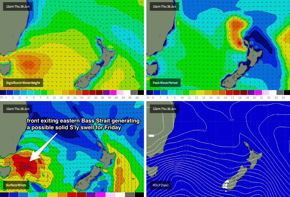
These fronts are expected to track unusually north in latitude across the eastern states. In fact, their southern extend will be just south of southern Tasmanian longitudes - which means that south swell potential from this source will be flukey through the middle of next week, as it'll all originate from gale-force W/SW winds in eastern Bass Strait (see chart below).
That being said, we sometimes receive unusually good waves from this source (it's one of my favourite sneaky south swell windows!) but you’ll have to keep a close eye on the southern NSW surf reports and surf cams as these pulses are often much harder to pin down in advance.
Current thinking is like this: Tuesday and Wednesday will generally be small trending tiny with strengthening NW tending W’ly winds. A small new south swell - very acute in direction - may impact the Lower Mid North Coast very late Wednesday but more likely Thursday (when it’ll also reach the North Coast), with occasional 2-3ft sets at south swell magnets and hardly anything elsewhere. Small intermittent pulses of similarly acute south swell will then filter through early Friday ahead of a stronger pulse of S’ly groundswell that’s currently expected to reach the lower Mid North Coast mid-morning and the Far North Coast mid-afternoon (with 3-4ft+ sets at south facing beaches, and only small waves elsewhere).
Unfortunately, these south swells will probably do little for the SE Qld coast so again - a trip south of the border will be well advised right through the second half of next week. However it’s likely that the timing of these swells will move around by Monday’s forecast so I’ll update the specifics as best I can then.
Longer term (June 28 onwards)
Friday's south swell will probably persist into Saturday, but otherwise there's nothing of major interest standing out in the super long range charts right now. Let’s keep a watchful eye to the southern swell window for the foreseeable future.