Focusing our attention to the south

Southeast Queensland and Northern New South Wales Surf Forecast by Ben Matson (issued Monday 16th June)
OK, first things first - sorry for the lack of updates on Friday. It’s been a mental week here (EOFY etc) and I simply ran out of time on Friday. Despite the best of intentions I was unable to update the forecast over the weekend either.
Secondly, and as a direct result of Friday’s non-updated forecast - we’ve seen a sneaky east swell fill into the Queensland coast today, under the radar. I’m happy to put my hand up and acknowledge that unfortunately, this swell wasn’t documented in Wednesday’s forecast notes.
However there’s an interesting backstory as to why this was the case (so please indulge me for a minute - if not, just skip to the next section...!).
The responsible fetch for today’s E’ly swell was associated with the broad, slow moving trough that developed off the NZ West Coast last week, which gave rise to a number of quality swells from several sources.
Early last week we already had two south-east swells in the water, then a solid SE groundswell from a low in the central Tasman filled in on Thursday, followed by two pulses of new SE swell on Friday - the second being quite strong, but mainly aimed towards the southern regions - that reached the coast late in the day occupied the region through Saturday. This last swell was generated by an impressive E/SE fetch east of Cook Straight mid-week (the body of water separating NZ’s North and South Islands). All of these swells created great waves right across the East Coast - it's been a super fun week of surf in most areas.
So, with all of this synoptic activity at hand, the mindset last Wednesday was that we still had three SE swells yet to arrive (Thurs, Fri and Sat) as well as a significant Tasman Low forecast to develop off the southern NSW coast over the weekend (which generated the strong south swell that’s in the water right now). So, there was no shortage of swell on offer for the coming four days. And although the fetch responsible for today’s swell was starting to show on the forecast charts, it was located a very large distance away from the mainland (around 1500km NE of New Zealand, over 3,500 km from the Qld coast, and partially tucked into our swell shadow).
Putting all of this together, and when I prepared the last forecast notes on Wednesday, there didn’t seem to be much justification for including every single fetch aimed towards the coast (especially as today's sourcecould have very well slipped into the swell shadow of NZ with updated model runs). But unfortunately, by omitting this fetch from Wednesday’s detailed discussion and then being unable to update the forecast on Friday (when it would have been duly picked up), this fun little swell slipped through to the keeper. Compounding the issue is that none of the computer generated models forecasts picked up this swell either - which is in itself another long discussion.
Anyway, hopefully next time I’m unable to update the forecast notes, it won’t coincide with a broad, complex troughy pattern like the one we saw last week! And with that out the sway let’s get back on track with this week’s forecast.
Best Days: Tues: solid but easing south swell in Northern NSW. Small fun E'ly swell easing in SE Qld. Wed: renewal of S'ly swell in Northern NSW but with dicey winds. Thurs: easing south swell in Northern NSW and improving conditions. Fri/Sat: small new series of south swells in Northern NSW, with good winds.
Recap: Fun SE swell from late last week through the weekend ahead of a new E’ly swell that arrived this morning, creating great waves across open beaches in the 3ft range. A strong south swell also worked its way up the Northern NSW coast this morning, delivering solid sets at south facing beaches (although not quite as big as southern NSW, where Sydney reached 6ft+ and Newcastle pushed 8ft+).
This week (June 17-20)
The focus for this week will be to the south, with a series of southerly swells expected to provide plenty of waves across the Northern NSW coast. Unfortunately, the existing E’ly swell will slowly ease from Tuesday onwards so SE Qld can expect a slow decrease in size over the coming days.
Right now we’ve got a pretty solid south swell in the water, which was generated by a Tasman Low that formed off the southern NSW coast on the weekend. It’s now tracking towards New Zealand post-haste, and is outside of our swell window so we’ll see a corresponding drop in size from this source through Tuesday as well. Exposed south facing beaches in Northern NSW should see early 3-5ft sets but it’ll be down to a steady 3ft by lunchtime or early afternoon, and locations not open to the south will be smaller again. Mainly moderate to fresh W/SW tending SW winds should keep the open beaches relatively clean.
A new front is expected to slip into the SW Tasman Sea on Tuesday and it’ll kick up a fresh south swell for exposed south facing beaches in Northern NSW on Wednesday. However winds are likely to tend gusty S’ly during the day (following a brief period of SW winds) so this will confine the best waves to sheltered locations (which will be much smaller). Exposed south facing beaches should see bumpy 3-5ft waves by the end of the day, with smaller 2ft+ surf at remaining open beaches.
A ridge will concurrently strengthen across the Queensland coast on Wednesday, and we’ll eventually see some short range S/SE swell in SE Qld into the afternoon - but no great size is likely north of the border (away from south facing beaches). So expect generally small surf across the Gold and Sunshine Coasts mid-week.
Thursday is looking at gradually improving but easing conditions as the ridge weakens and the southerly swell(s) fade across the region. South facing beaches will continue to rake in the most size and with better winds there should be some fun waves on offer in Northern NSW (mainly in the south, where winds will be lightest).
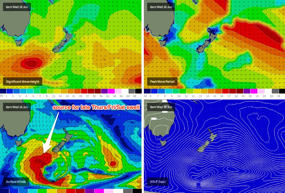
Friday looks really interesting for open beaches along the Northern NSW coast. A series of strong fronts traversing the Southern Ocean well to the south of Australia are expected to track NE below the Tasman Sea mid-week, on target for New Zealand. Although unfavourably aligned for Australia’s East Coast, they will generate a couple of good pulses of long range S’ly then S/SE swell for the region (see chart below). No major size is expected but with good winds on hand it’ll be worth sniffing out an open beach break. Our model isn’t picking up these swells very well so I’m going to go against the consensus and forecast above their computer-generated estimates.
The first pulse of swell is due into southern NSW on Thursday and may reach just tough the lower Mid North Coast (around Seal Rocks/Forster) before dusk, however most locations in Northern NSW won't see this swell until Friday. It won’t be very large - say, 2-3ft+ sets at exposed south facing breaches - but winds should be light and variable so conditions will be clean. A second pulse of marginally stronger swell is expected into the afternoon so keep an eye out for a few bigger sets here and there.
However - SE Qld won’t pick up much size away from south facing beaches so expect small residual swells here for the end of the week. Either that, or plan a trip south of the border.
This weekend (June 21-22)
Friday's swell should continue motoring across the coast through Saturday morning, albeit quite inconsistent at times. By Saturday lunch, another pulse of energy from this same system mentioned above is expected to begin showing across Northern NSW, and it’ll probably display the longest swell period of the lot. It’s forecast to be generated by a developing polar low that’s modelled to merge with the frontal system well to the south of New Zealand overnight on Wednesday and into Thursday morning, (and will probably be responsible for both a massive swell and a significant dump of snow in southern NZ!).
Anyway, this fetch is expected to kick up a decent S/SE swell that should produce good 3ft+ waves at south facing beaches into Saturday afternoon but with very long breaks between the bigger sets. Again, very little size is expected in SE Qld from this source (although a few 1-2ft sets may appear every so often if you’re lucky). Surf size should hold into Sunday morning but will ease throughout the day.
As for the weekend’s winds, current guidance suggests early W/SW flow tending SW on Saturday ahead of a SW tending S’ly airstream on Sunday. Let’s firm up the specifics on Wednesday.
Long term (June 23 onwards)
Nothing major on the long term charts right now. If anything there’s a hint that we’ll see a similar progression of Southern Ocean fronts through next week, leading to a couple of pulse of moderate south swell with generally good winds - but I’ll have a closer look in Wednesday’s update.