No shortage of swell over the coming week

Southeast Queensland and Northern New South Wales Surf Forecast by Ben Matson (issued Monday 9th June)
Best Days: Tues/Wed: small windy waves at the exposed Qld points if you're keen. Thurs: fun SE thru' S/SE swell in Northern NSW with good winds early (only small in SE Qld). Fri: powerful SE groundswell developing after lunch, with generally light winds. Sat: easing SE groundswell with freshening W'ly winds. Sun: solid S'ly swell building across Northern NSW.
Recap: Bit of a fizzer over the weekend in the surf department, even though it wasn’t really worth getting excited about anyway. The long range E’ly trade swell that originated east of NZ longitudes failed to deliver much more than couple of inconsistent feet at exposed beaches, and the other short range sources of swell fell short of expectations too. However with gusty S/SW thru’ SW winds on offer there wasn’t much to work around.
A new S’ly swell has started to build across the region today, but it’s not showing up everywhere (as a guide, Newcastle reached 4-6ft this morning, and exposed south facing beaches in Northern NSW should reach a peak this afternoon). Our surfcam at The Pass has shown plenty of lines in the chest/shoulder high range today (not bad for a swell with some south in its direction) however very little size is getting into SE Qld beaches due to the swell direction.
This week (June 10-13)
First things first - if you take a look at the synoptic chart, you’ll see a developing trough in the Coral Sea over the coming 24 hours. This is quite an unseasonable weather system, and unfortunately it won’t directly produce any swell for the SE Qld coast. It will however indirectly generate some short range energy, by way of a strengthening ridge across much of the East Coast.
This strengthening ridge will also affect much of the NSW coast on Tuesday too, so we’re looking at a windy combination of easing southerly groundswell (from today) and rebuilding short range SE swell that’ll hold through Wednesday. Winds will be fresh SE for much of Tuesday (possibly S/SW in a few localised areas early morning), and they’ll slowly ease into Wednesday and tend more S’ly.
Exposed points in SE Qld should have some small runners during this time frame but it’s hard to imagine there being many suitable options in Northern NSW over the next few days - especially with a great forecast period ahead.
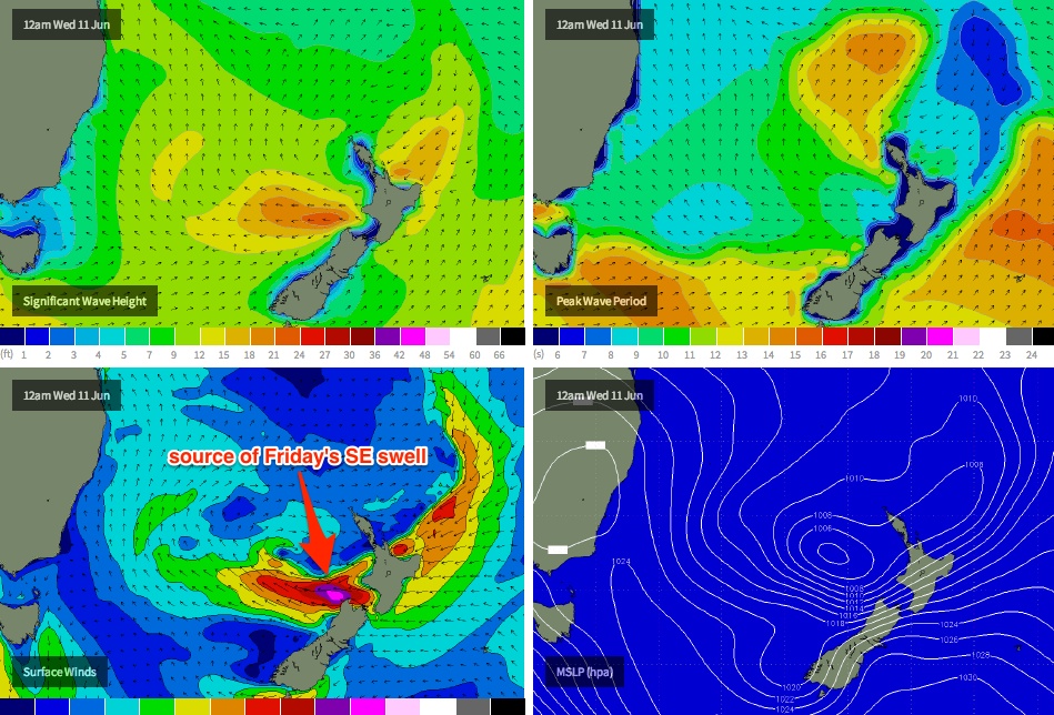
A complex, deep trough currently lies off the west coast of New Zealand, and it's expected to be an active source of swell for the entire East Coast for the rest of the forecast period. Right now a small S/SE fetch off the SW tip of New Zealand’s South Island is strengthening around a small centre of low pressure that's modeled to pinch off from the trough into Tuesday, tracking north-west into the central Tasman Sea. The computer models have slightly upgraded the strength of this fetch since Friday, but our wave model isn’t resolving it very well - so I’m going to call above the size currently listed on the graph (which is about 3ft).
The tricky part about this anticipated swell is the timing - it’s forecast to arrive during Wednesday afternoon in southern NSW, and will probably reach the Northern NSW coast overnight Wednesday before peaking early Thursday and then trending down through during the day. The swell direction is expected to be somewhere between SE and S/SE, which unfortunately means SE Qld will see much smaller waves than Northern NSW.
However the good news is that the mid-week ridge across the coast will have relaxed considerably by this time, so Thursday morning should dawn reasonably clean with moderate SW winds across most regions, and with open south facing locations in Northern NSW peaking somewhere between 3ft and 5ft, there should be some great waves about the reefs and exposed points. North of the border, the surf will be considerably smaller form this source (inconsistent 2ft at most SE Qld beaches, reaching 3ft+ at exposed south swell magnets) but conditions should be nice for the early surf. Expect freshening southerly winds during the day (probably not with any great deal of strength, though).
Friday is shaping up to deliver some really good waves. A weak ridge of high pressure across the region should maintain light and variable winds for much of the day (possibly an afternoon N’ly tendency), and a solid new SE groundswell is expected to arrive after lunch, building towards an overnight peak in size. This swell will have originated from a secondary low forming within the trough off NZ’s West Coast later Tuesday and Wednesday, which is expected to exhibit a sustained fetch of 40kt+ E’ly winds west of Cook Strait.
By the end of the day, set waves should approach the 5-6ft+ range at exposed beaches and reefs in Northern NSW - with the upper end of this size range more likely along the Mid North Coast, where the fetch will be best aimed. This swell isn’t looking quite as good for SE Qld, so we’re on target for late 2-3ft waves on the points that may reach 3-4ft+ at exposed south facing beaches. It's worth nothing that this swell is expected to be quite powerful with a healthy wavelength/swell period. Prior to its arrival, expect residual SE swell leftover from Thursday with early light winds.
The only points of concern I have for Friday afternoon's new swell is (1) the overnight peak in size, and (2) the afternoon N’ly tendency in the wind (which will crop up as the swell reaches its peak). However let’s take a look at the available data on Wednesday to see if these concerns are still warranted.
This weekend (June 14/15)
Friday’s late strong SE swell should persist into Saturday morning with set waves between 4ft and possibly 6ft at exposed beaches first light in Northern NSW (but only half this size in SE Qld), however it’ll quickly trend downwards throughout the day. Fresh westerly winds will envelop much of the coast as a front crosses the region.
Sunday’s on target for a possible solid short range south swell in Northern NSW, courtesy of a deep low that’s modelled to develop off the southern NSW coast early Saturday. This event could become quite sizeable at the swell magnets but we’ll have to wait and see how the model data pans out over the coming days. The good news is that right now, most weather models in general agreement about the location, timing and strength of the low, so there’s a pretty good chance it’ll happen. Unfortunately, SE Qld rarely picks up anything worthwhile from these systems so after Saturday we could be looking at another spell of small surf.
Long term (June 16 onwards)
The weekend’s impending low pressure system looks like being a fairly typical winter Tasman Low, which - if it follows the climatological script - means we’ll see a peak throughout Sunday and then a steady trend downwards from Monday onwards. Otherwise, there are no other solid sources of swell for the longer term period - the long range charts have a deep low sitting NE of New Zealand over the weekend (that could generate a small long period E’ly swell for the middle to latter part of next week) however this is a long time away and the system is forecast to be in a position that’s right on the periphery of our swell window. Let’s take a closer look at this low in Wednesday’s notes.
Comments
Fecking devil wind!!!
Models are still totally divergent on the winds down here Saturday, bit frustrating, but hopefully it tends ECMWF's way.
This morning's EC run was progging devil winds up here for the peak of the swell. GFS is going leaps and bounds in it's devil wind forecast for the same time!!!!
Even when the winds do go offshore, the devil wind will have created a lovely low period N'ly windswell which will no doubt otherwise ruin a damn good groundswell.
No "devil wind"....... Just E -Ne sea breeze..... Perhaps kongs left might be worth a look..... Or maybe where you went camping a while back, Don..... Then there's always the ferry to ...............
I think you're referring to Friday arvo Sheepie? I wasn't referring to Friday arvo.
And again mate, NO NEED TO NAME LOCATIONS PLEASE!!!!
FFS, Don...... There is no break called "kongs left'.... I'll properly name it seeings you've already scalded me for it........... It's actually called..................... lol
And when exactly is this "devil" north wind due? Just before the trough I predicted back on the 2/6 which you doubted I assume? ;)
SD, KL's isn't a secret name for it. And when did I ever doubt the trough you predicted back on 2/6? I think I just questioned which charts you were referring too, and once you pointed that out to me, did I ever doubt your prediction?
Mate.... It's never been known as kongs left....... ever....... I joked and called it kongs left here a few months ago in a cryptic discussion with you and Mitch by memory..... In fact, in the "movie', the one that never mentioned the place, they never even surfed the left.......
There is another left down the road that Kong also frequented...... It may also be "kongs left".... He and this left (photo) were in many tracks/lineup magazines.....
ps - awesome wave WHEN it breaks........ rarely........
Ahhh SD you changed your post...... Did some research did you. There is a well known break that is commonly referred to KLs but if that doesn't exist (as was your original post) then there's no need to discuss on open forums or post pictures now is there!!!
I didn't change my post....... Cmon, don....... This is the forecast for S.E qld nth nsw......... Not Fiji.... Why the hell would I be talking about fiji in regards to this thread, where I mention your "camping spot" (which you named back them btw ;) )or ferry rides .......
You know exactly the left I was talking about..... No semantics......If you didn't, well........ NO USE USING CAPITAL LETTERS IF YOU COULDN'T WORK IT OUT....... :p
So you never wrote "FFS, Don...... There is no break called kongs left..........."?
aha aha aha aha aha aha aha aha aha aha....... and so on. lost your bark little yap dog????????
Don and snotsweat..... Don, if you want to continue semantics, fine.... You know what break I was referring to...... You know that IN CONTEXT, we were discussing the Qld/nnsw report..... In the qld nnsw forecast....... You know IN CONTEXT there is no break in QLD/NNSW called kongs left......
And if you want to continue semantics, Kongs at gland isn't "kongs left". It's just "kongs.......
For there to be a kongs left, there must be a kongs right.......... In Fiji it's called King kong left....... Along with King Kong right....
There is no "kongs left"...... See, Don , semantics not only attracts nutters, it can be fun too ;)
Ok cool so we don't need to mention KL in the SC thread ever again. BTW One of my mates knows Kong himself so he texted him last night and asked the question and he responded with exactly the location I was thinking.
Ohhhhh...... Ok...... So there IS no KL, right Don?........... I hope your little boogie boarding supporter takes note........... (Do you know him?)
BTW. Did your mate's sms to gary ( he's not called kong anymore ;) ) include the CONTEXT of the discussion in the sms? ( the fact that it was a chat about the s.e qld)........
If your mate gave gary a "legs up" and said, "Don and a bloke named sheepdog from the sunshine are talking about a left in **** ********,"..... well what do you think gary would say, Don????? Point "feckn" Cartwright?
Or was it generic sms that simply asked "have you heard of kongs left?" If so, I bet gary would've said "There's a couple of breaks you might be on about..... Gland...... Fiji......, but one's called Kongs, and the other King kong left ".......
Cmon, donny.......Your semantic to and fro is a diversion for your mistake... ..... Cmon mate :) In, fact, your position on this has actually promoted more of a spotlight.....
I just wanted to chat to you about E' ene ' n winds, "devil winds".... when..... what strength...... the fact that strengthening northerlies are common before inland troughs and fronts move offshore to form lows, and have nothing to do with elnino...... But hey, forget it man....
And if I want to cryptically mention "kl", I will....... Only "kong", you, mitch, and a few others are smart enough to work it out...... I'll call it oompa loompa left if it makes you feel secure........ :p I know Swellnet is popular, Don, but I don't think it's up there with masterchef..... There are not 5 million surfers reading the se qld forecast...... There is only a dozen or so of us chatting....
Hmmmmm.... think I will name it....... I'll give a full run down on conditions, swell angles, best wind.... I mean, I've already copped the grief for it, right? ;)
OK SD, forgive me, my mistake. I'm wrong and your right as per usual. Shall we move on now.
And how the feck would you know what the feck Gary Elkerton calls himself these days!!! My mate stays at his place down at Ocean Shores on a very fecking regular basis and goes every fecking year to Indo with him, so I'm pretty sure I'd trust him over you.
I think this has gone beyond the point of spotlight and would be surprised if anyone else bothered to read, and if they did, knew what the hell you guys are on about!? Me included haha
I'm sure when I lived on the NSW south coast, there was a wave they called Kong's Left, maybe from an old video of Kong himself surfing it at a big size which it is not known famously for.........Not sure if it was GI....
How narrow do these replies get SN..?
D
o
t
h
e
y
g
e
t
t
h
i
s
n
a
r
r
o
w
.
.
?
Yep, you're right mitch..... Sick of semantics here...... Ego's....... Go back to my original polite post that didn't name a break...... Take it from there.. Done with it.... See ya's in the forum section......
is semantics the word of the day on sesame st in tasmania??? fuck, even when ur wrong ur still right shit dog! let it go b4 u dig that hole deeper.....ha ha ha ha ha ... i know gary......ha ha ha ......name dropper.
there's a moon in your eye like a big pizza pie, thats El Nino.
Think you're drawing a long bow re one swell event being met with northerly winds and El Nino.
LOL Steve. El Nino can go feck itself if it's consistently going to ruin every good swell we have!!!
I was only joking Craig but it does seem to be a feature of Nino years.
Was hoping so, although if my memory is right during the last strong La Nina a lot of early Autumn swells were being scarred by northerly winds.
Mitch, if you are out there, can you remember where I posted for you that winter trough that formed into a low off Townsville a few years back?
Don't worry, mitch, found it... If any weather watchers are interested, go to map archives at BOM, and check out 24/6, 25/6, 26/6, 2003, for an inland trough that bombs off townsville........
Please allow me to introduce myself
I'm a man of wealth and taste
I've been around for a long, long year
Stole many a man' soul and faith
And I was around when Jesus Christ
Had his moment of doubt and pain
Made damn sure that Pilate
Washed his hands and sealed his fate
Pleased to meet you
Hope you guess my name
But what's puzzling you
Is the nature of my game
It's too reveal all your secret spots
You'll only have yourselves to blame
Details gentlemen if you will, details...