All eyes on the weekend in SE Qld (plus bonus ice floe discussion!)

Southeast Queensland and Northern New South Wales Surf Forecast by Ben Matson (issued Monday 12th May)
Best Days: Fri/Sat: fun building trade swell in SE Qld and across the Far North Coast
Recap: Strong but easing SE swell all weekend with fun waves across the North Coast, smaller into SE Qld. Very small residual swell on offer today.
This week (May 13-16 onwards)
It’s not a great surfing week ahead for either the North Coast or SE Qld. With a lack of significant swell generating systems in any of our swell windows right now, we’re mainly looking at small residual swells up until about Friday, when the SE Qld region should see an upswing in fun peaky tradeswell.
A building ridge across the Qld coast over the next day or so will whip up a small short range S/SE tending SE swell from Tuesday thru' Thursday, but it'll be biggest at south facing beaches and they'll become quite wind affected during the day (expect very small but clean surf on the open points). Not much size is expected from this source in Northern NSW.
Last week the models were suggesting we’d see a stalled trough off the East Coast, however in the latest runs they’re tracking this north-east into the central/northern Tasman Sea, and aimed outside of our swell window. One model (ACCESS) still has a small chance for a small peaky east swell during the middle of the week, thanks to its expectation that the trough/low will retrograde slightly back towards the North Coast, but this is an outlier.
As such, the dominant swell event of the week (if you can call it that) is a small long period SE swell due to arrive throughout Wednesday, having been generated within a rare part of our swell window late last week.
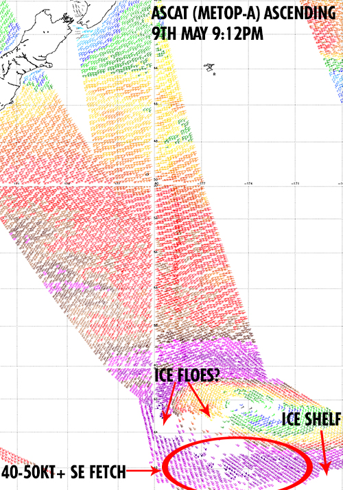
A deep Southern Ocean low formed well to the S/SE of New Zealand on Friday, momentarily stalling and forming a small but intense band of storm force SE winds off the ice shelf, aimed briefly at the Australian East Coast. As I said in last week's notes, the small fetch length, short duration and large travel distance will probably restrict wave heights across the East Coast, so in reality we really can’t expect much more than a couple of feet across exposed beaches.
However, there’s an interesting curveball contained in the image below - this is the ASCAT pass from Friday night, which captured the low and its associated fetch very well.
But if you pay close attention, you’ll notice an area with no wind barbs (white patches) upstream from the SE fetch. This is quite unusual - scatterometry is not affected by cloud cover - and suggests that there may be a broad area of drifting sea ice sitting well north from the Antarctica ice shelf. Although I'm not entirely sure (and drift ice is certainly not an area of my expertise).
The reason this is worth noting is that (with limited analysis time up my sleeve) the storm force SE fetch mentioned above lies across and to the south-east of this possible ‘giant ice floe’, meaning that the resulting swell generated by this SE fetch would probably become heavily attenuated by it (I’m not sure on how much it would influence wave heights, but it’d be reasonable to suspect it’d have a significant negative affect).
I'm unsure whether the wave model has taken this specific area into account or not - I know that sea ice is included in the model's data assimilation but if this was a major swell event I'd probably hone in more specifically to see whether this is indeed a 'giant ice floe' and whether its presence would trigger a recalibration within the wave model.
Anyway, all this means is that an already flukey weather system in a remote, difficult part of our swell window has thrown an even bigger curveballs our way. I doubt we’ll see much more than an inconsistent 2ft at exposed south friendly beaches anyway, but let’s wait and see what happens!
Elsewhere, the trades south of New Caledonia and through the southern Coral Sea are expected to join forces mid-week, leading to a build mid-range east swell from late Thursday thru' Friday that is expected to peak over the weekend. At this stage the end of the week should see 3-4ft sets across the Sunny Coast, 2-3ft sets across the Gold Coast and smaller surf south of the border (with very little getting in south of about Yamba). Well worth penciling in an early minute from work - or some flexi time - at this stage.
This weekend (May 17-18)
No major swells are expected from the southern or south-eastern quadrants this weekend - it’s all trade swell on the charts. And the biggest beneficiary will be the Gold and Sunshine Coasts, who’ll rake in the most size. We’re looking at set waves in the 4ft range north of Brisbane and 3ft to the south (peaking Saturday, easing Sunday), and as you drive over the border surf size will progressively become smaller with increasing southerly latitude.
Long term (May 19 onwards)
Nothing major on the cards for next week. An amplifying long wave trough over the western half of the country will allow a strong ridge to develop over the eastern states, which will probably deflect a significant percentage of Southern Ocean lows away from our swell window next week (although one low may slip in just before this - passing south of Tasmania on Saturday, with a possible south swell for the North Coast early next week).
Otherwise, apart from small fluctiations in trade swell across the SE Qld region, we could be looking at small surf for a while. More on this in Wednesday’s notes.
Comments
Hi Ben, was wondering why we aren't getting the consistent offshore winds normally associated with this time of the year? Have we skipped the autumn patterns and rolled straight through to winter?
Not really sure - seasonal trends aren't really my speciality, however it's been a weird summer/autumn period anyway - a couple of good weeks of waves here and there but otherwise rather patchy (especially in SE Qld). I'll have a chat to the Weatherzone guys to see if they have any thoughts on the overall pattern this year.
Ben, thanks for the quick reply, I tend to get a little excited at this time of year as my local beach break can get consistently fun. Would really appreciate if anyone could shed a little more light on the subject.
Perhaps those "holes" in the ascat pass were due to some bugs on the sensor of the ASCAT satellite? ;)
Then wouldn't we see them elsewhere?
Ummmmm, I was taking the piss Ben!!!
Ahhh.. I thought you meant 'bugs' as in tech bugs not physical bugs!
Lol. Perhaps I should have written insects instead of bugs then.
Ben, do you think we will see any size this weekend in the port macquarie area? Or will be like Sydney 1ft - flat? thx
At this stage it's looking pretty small, probably just a foot or two of trade swell at the swell magnets.
Ben, how are you reading the winds for the yamba area on the weekend? Models are saying light e/se. I have a weekend catch up with mates that would be cruelled by all day onshores. Any chance of some early morning offshores?
Yeah should be morning offshores in the Yamba region. Latest model data has perked up the size expectations too (right across the SE Qld/Northern NSW region) which suggests another foot or two on top of what I was expecting when I wrote yesterday's notes. But let's just give it another day to see whether it's an aberration in the models.
Yeah and it's also perked up the local winds for SE Qld/Nth NSW also Ben which means very little chance of clean offshores early morning. Swell will also likely be wobbly/gurgly due to persistent overnight onshores.
This is late Autumn yeah? :(
It's been a weird season, a kind of Quasi El Nino pattern which saw fcuk all trades and highs not anchoring in the favourable position.
Summer felt like the endless Spring and Autumn-up until the last tasman low/cold outbreak was an extension of summer, ala with outbreaks of shit winds at inopportune moments....
Now we seem to have skipped straight into a schizophrenic pattern alternating between winter type south swells and an upcoming onshore pattern.
As we breach the autumn predictability barrier it'll be interesting to see what happens. That stubborn warm water off the NSW S coast has to do something surely.
"That stubborn warm water off the NSW S coast has to do something surely."
Feck I hope so Steve!!! As the last 6 mths have been dire with respect to consistent/favourable surf in SE Qld. I'm almost ready to throw the towel in with respect to surfing!!! It's just doing my head in with these fleeting one day surf prospects followed by upteen days of shit!!!
Don mate, ease off the angry pills! Kidding. Did you score the last swell? Dunno how Thu/Fri went, but I'm sure you knew where it was at Sat/Sun...
By last swell I assume you mean the weekend I was away (Sat May 3 - Tues May 6)? Saturday we scored a very surprising 2ft E/NE swell that appeared to sneak under the radar. Very fun session indeed. Sunday was tiny, and I mean tiny. Monday was solid and we scored some real fun 4-5ft waves at a non south facing location. Tuesday was back at the same place but smaller 3-4ft waves. Dropped in at Steve's neck of the woods on the way home and found some 3-4ft+ beachie peaks but feck me it was crowded!!!!
Oh and the wind pretty much blew offshore for the entire 4 days so we can't complain.
Nah actually I meant the weekend just past...! a 100 clicks south of Steve's was good all weekend. That devil wind seemed to be worse around the cape and not further south somehow.
That tuesday you mention though, the most obvious (maybe 2nd mosst) spot was not so busy.
twas pumping Fri/Sat/Sun.
didya get some of that action DonW?
Nah Steve. After having 4 days off the previous weekend I didn't want to stretch the friendship with Mrs Donweather. It was Mother's Day too!!
Sucker!!! :P
Yes, I bought my wife a new board for Mothers day so conveniently we were down the beach in front of some very nice point surf.
when she had caught her fill......
The rating system contines to be cuckoo clock crazy for this region.
Today has improved significantly in size and quality. There's head high peelers everwhere. It' s autumn. Nothing amazing but a bog standard day with fun waves.
That should be dead average. A five or six out of ten.
The rating gives it four. Now when I went to school a four out of ten was a fail. How can a bog standard autumn surf day get less than five out of ten?
And yet the day of the year: ruler edged six to eight foot surf with blue skies and offshores gets a seven? wtf?
Thats as good as it gets. It should be a nine or ten.
At least he's aligning with you Steve in that he rated today half as good as the ruler edged 6-8ft day, just as you have done (5 versus 9-10).
Perhaps he's wanting a Code Red swell before he gives it a 9-10? ;)
thats what I mean: whats he waiting for?
there was head high point surf for most of the day today and it was deemed a fail?????
Most people would cut off their left testicle to surf fun head high pointbreak.
Who's "He" ...?
What about a 3.789 rating times by 1.239 to the square root of .099 +A SQUARED - C SQUARED = THE OVERALL AVERAGE OF A SURF RATING BY "HE", WHAT DO YOU BLOKES RECKON....!
Would love some feed back, as I'm so confused with all these ratings :)
yeah im not sure about the testicle amputation FR...ouch!
Gees Shearer isn't it better to underscore the report and maybe keep a few of the less keen travelling surfers off it than give the whole show away and have the place packed out every time there's a hint of a wave? I kinda think that if a surfer is worth his salt, he can check the swell, wind and tide forecasts then make up his own mind of where will be good without having to be spoon fed with ratings etc. Might even make for a few less at some of the more popular spots if peeps actually had to get of their arses and check the conditions themselves. Just a thought….
Its Freeride76...?
Who's Shearer...!
Freeride 76.
The free ride voice.
Stephen shearer.
The outsider...........returning soon.
Shep.........Tahiti looks nice .
You maybe right Seal, but to be honest I haven't noticed any correlation between the ratings and the crowds. Easter Sat was rated a seven and there were a hundred blokes in the water at sunrise......
it seems more related to who gets on the mobile first and starts ringing around.
Yeah Steve the mobil phone is a major contributor to crowds, as is detailed surf forecasts, in that a swell size, angle and wind conditions are detailed days in advance of hitting a particular area hence the crowds at Lennox onto the swell over Easter.
It's great that the science of swell prediction has gotten to pretty accurate levels, for the travelling or lazy surfer, but it hasn't done the surfer at his local much good crowd wise.
Don't get me wrong, I like to look at Swellnet too so I can get an idea of what is gonna be like if I'm travelling but I'd love to see it dumbed down so the punters have to make their own decisions on where is likely to be good and not spoon fed all the details.
I know you guys take a lot of pride out of getting your forecasts as accurate as possible but it would be nice if you'd throw a few dummies every now and again so that those that actually check the conditions can get a head start and not turn up to punters already there waiting for the show to start
But it also works the opposite Seal. When the forecasts are saying nothing, and something sneaks under the radar you can get some good fun uncrowded conditions. I've scored this numerous times. Granted you don't get 4-6ft swell sneaking under the radar, but you certainly get 2-3ft sometimes.
Crowds get severely tapered when it's over 4 or 5ft too, wouldn't you agree? Whether it's a point, beachie or otherwise? But then again, that's when you gotta sniff out the ones that the ripping locals don't get I suppose. Or just go hammer and tongs at the peak with everyone else if it's dbah for example
Gee Don, I hope you're not suggesting that surf forecast sites do add to crowding! That would go against the grain of what some forecasters try to tell us wouldn't it?
Day before yesterday SEal there was twenty blokes out at local spot. Day before that : none. Yesterday: none. Fun surf every day.
Yesterday was actually given the highest rating by the surf report.
There is a relationship but it's definitely not linear.
Steve are you trying to tell me there is no connection between crowds and surf forecasts/reports?
The past few days have been east swells so of course there has been waves everywhere and numerous breaks have been working even Byron would have had waves so thats why he gave a higher rating.
But because it's an east swell it spreads the crowd out nicely except places like Snapper & Byron of course (more crowded) and really who gives a fcuk about ratings? What I'm saying is, don't give out too much info and make people work for their waves not spoon feed them.
Would you call Tallows and Lennox sacrificial breaks in this system? I.e. people know there'll be waves, but those who can't really figure it out just swamp these joints?
Seal you're last sentence hits the nail on the head big time!!!! My sentiments exactly!!!