Small swells all week

South East Queensland and Northern New South Wales Surf Forecast by Ben Matson (issued Monday 28th April)
Best Days: Tues/Wed: fun S/SE swell in Northern NSW. Sun: solid building south swell, best suited to Northern NSW. Next Mon/Tues/Wed: plenty of strong south swell for Northern NSW.
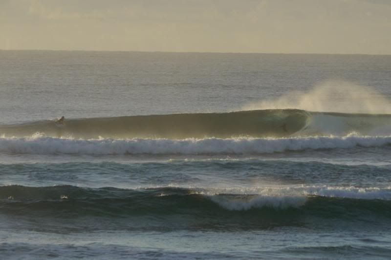
Recap: Small waves for much of the weekend, consisting of a minor trade swell and a small pulse of southerly swell across exposed beaches in Northern NSW. Building short range SE swell has padded out SE Qld and the Far North Coast today, with a moderate S'ly swell pushing along the Northern NSW Coast.
This week (Apr 29 - May 2)
Unfortunately the southerly groundswell originally forecast for Tuesday has been significantly downgraded.
The main reason for the downgrade is that the fetch strength around the low/front in the Tasman ended up being weaker than what the models were forecasting late last week. They also refocused their alignment more towards the NE (aimed further away from the East Coast) with the fetch sitting more across the central/eastern Tasman, rather than the central/western Tasman.
Still, we should see a building trend throughout the day - probably not until lunchtime in SE Qld - and exposed south swell magnets in Northern NSW should pick up the bigger waves with sets in the 3-4ft range (expect smaller surf elsewhere). Our model guidance is a little more optimistic than this but I’m cautious about this swell due to the massive swings over the last few days.
Surf size in SE Qld will be much smaller from this source (say, 2ft+ exposed beaches, smaller on the points as it peaks into the afternoon) however there'll still be some short range SE energy in the mix of a similar size, originating from the existing local pattern. So, there'll be some fun small waves on offer throughout Tuesday.
Wind wise, we’re expecting a mixed bag. SE Qld will see the lingering effects of a weakening ridge, which should mean a light SW airstream at dawn tending moderate SE then E/SE throughout the day.
Winds should be light and variable about much of the Northern NSW coast ahead of a freshening N/NE breeze in the afternoon, however there’s an axis point between the two (say between Byron and Yamba) where anything could happen - including a morning onshore. So I'm not totally confident for great waves on Tuesday in the Far North of the state right now.
Still, keep an eye on the local wind obs - northern corners (particularly across the Lower Mid North Coast) should be quite fun from about lunchtime onwards.
Steadily easing swells and freshening NW tending W’ly winds are expected on Wednesday, which should be primo for most of the open beaches in Northern NSW. Size will be a lot smaller in SE Qld owing to the southerly component in the swell direction, so aim for the swell magnets for the best waves.
Tiny surf is then expected for the rest of the week. A minor pulse of short range south swell is then modelled to push up along the Northern NSW coast on Thursday afternoon and Friday but there won’t be much size in it, just the odd 2ft+ set at the swell magnets, and not much elsewhere. Winds however should be generally favourable so it’s worth scouting around the open beaches for something rideable.
As for SE Qld, we’re really not expecting much in the way of decent surf for the second half of the working week so make the most of what’s on offer on Tuesday and Wednesday.
This weekend (May 3-4)
Since late last week, model guidance has been rather honed in on a major Tasman Low developing off the South Coast early this weekend. It’s still holding true but right now it’s hard to have total confidence in the likely size and timing of the resulting swell. Especially for SE Qld, which rarely picks up any swell from these kinds of weather systems due to the acute southerly direction.
Saturday’s looking to be mainly very small and windy with fresh offshore winds as the low develops off the South Coast, but Sunday’s on target for a reasonably solid increase in new south swell for the Northern NSW Coast that could reach 4-6ft at south facing beaches by the afternoon (with abating W’ly winds at the same time). However we'll see much smaller surf at locations not exposed to the south.
At this stage I’m not expecting much more than a foot or so across the bulk of SE Qld beaches however the region's handful of quality south swell magnets should pick up some 2-3ft sets at the height of the swell late Sunday.
Let’s check back on Wednesday to see how the models are resolving this system.
Longer term (May 5 onwards)
Sunday’s swell is likely to hold through Monday morning, before easing throughout the day. Looking beyond this, and there are a lot of fronts expected to back up across the SE corner of the country from the weekend onwards, in a classic winteresque pattern. This should ensure a steady supply of similar south swells right through most of next week.
Comments
To continue on with the convo from a few days ago about seasons changing, does anyone have any comments on the jet? Does it normally shift northwards proportionally to the surface patterns?
What do you mean Mitch? Are you referring to the overall position of the Jet from season to season, or in relation to specific weather systems?
Firstly season to season. And does this next system signify anything? E.g. probably the first front to pass into qld...
Geezus 00z GFS run looks fecking woeful!!! I hope the 00z EC run looks a lot better!!!
EC looks incredible... 8-10ft+ Sydney but very windy. Still need a few more days though. Either way we're looking at one hell of a dynamic system!
But you agree EC is delaying the system with each run which in my experience is not a good sign of it coming to fruition?
Guys, where can I view these various models your referring to?
GFS is the same as SN's WAM pages but you can see the charts at weather zone also.
http://www.weatherzone.com.au/models/?lt=wzcountry&lc=aus&mt=gfs
EC can be found here
http://www.ecmwf.int/products/forecasts/d/charts/medium/deterministic/ms...
And just for good measure here's Access G also
http://www.weatherzone.com.au/models/?lt=wzcountry&lc=aus&mt=accessg
Don. An incredibly stubborn area of high pressure thousands of K's away has contributed to this flat spell, believe it or not...... The only hope I see for anything from the east is a breakdown of this system, which may occur Fri/sat...... There is an outside chance of a long distance swell after then....... An outside chance only...... a small, inconsistent but clean swell..... It's all dependent on an area of low pressure splitting into two systems, the ne feed into the northern system ,and another high forming east of NZ, hopefully cradling the fetch .......
SD I know what you're referring too but I think that fetch is all a bit late for my surfari this Sat-Tues!!! Ie I think that swell you're referring too arrives Wed next week.
Well it appears Huey is being a prick with this one and EC is now comin into alignment with the poorer GFS forecast!!!
Don, I noticed you've been keeping track of which models end up being the most accurate. Is it helpful to compare how the model compares in the pre/early stages?
e.g. the model forecast: a front which feeds into the 'low off the SE coast of Australia'. This front is forecast to hit SW oz by now. Has it? If, say, GFS modelled this accurately on its 00Z 28/4/14 run, then is it fair to say that it will get the rest of the system right?
Anyway, I just don't know how you keep track of 8 models/day!
Still looking OK for southern NSW :D
But yeah, not as much size for Northern NSW and bugger all for SE Qld.
Still, there's probably still another two or three systems behind this that'll kee the region flush with activity for much of next week. Surely one of them has to lineup a little better?
But you've still forecast 4-6ft for nth NSW Monday?
That comment was based around a quick scan of the mornings model runs. They've changes a few times since then, and I've swung my thinking back inline with a more positive outcome.
apparently it's 2-3ft this morning and a 4/10.
Lucky this bloke ignored the report and went surfing.
If this morning was a 4 I'm fucking George Clooney.
How does Monday, full on shore crap and today score the same rating, he must only look at it from the top of the south facing swell magnet at the light house and can't see the waves through swell
since I've chimed in before, I may as well chime in again.
I don't particularly care for the rating, I had a ball with one other bloke out in the tallows shorie on mon arvo. 7/10 for enjoyment. 7/10 the waves I surfed. 5/10 for consistency and positioning. 3/10 for the entire setup, considering what it can be. Report wasn't inaccurate.
Problem I have is that me, and I think most people, think along the lines of... how big is it at the swell magnets? if it's bigger than 3ft, should I go north or south to avoid onshores and crowds? report: 2-3ft sw'ly, bigger at magnets. me: hmmm, it's pretty borderline, don't wanna waste time spot checking. Well let's just head straight to tallows anyway... Ideally we could read the report and go: the tweed is ok, or we need to go south. Avoiding Byron altogether would be ideal.
I see a few little sliders up qld way today, Don...... 21/4/14 12.48pm --- "Wellymon, tobym - worst case scenario would be some ok trade swell 27th ish onwards... Dunno if the low out beyond Fiji will do much re' "cyclone".. You never know..... But it looks like it may give extra length to a fetch with that high moving ove NZ 29th/30th... We'll see....."
Well, the high did stall this side of Nth NZ, did created an average fetch against some broad sunken muck associated with the low, and we do have some trade swell, on the 30th.
Doggie, do you have any hindcast links? I've looked at the stormsurf hindcast, but I can't see what you're talking about. The report and buoy look alright though
Mitch, about the best that I can find.... Note small trade squeeze 27/28/29th..
http://www.stormsurfing.com/cgi/display_alt.cgi?a=spac_slp_hc
Caused those s/easters over the past few days.....
ok cheers, I wouldn't really have expected 3ft sets from the ENE (buoys all tended that way) in the mix from the charts, But yeah, worthwhile call for the sunny coast. There is sth a groundswell visible on the pt lookout and byron buoys, so maybe some of that is making it's way to the nth end sunny coast too...
Just to clarify, I'm imagining that only the fetch west of 170E provided anything surfable, the fetch further E looked a bit too weak at 20kts max
just local trade stuff..... 8 seconds.... from below and inside of new cal', to down off byron.... Thats it..... nothing more..... will die off quick...
yup. Ok, hard to see that at the scale of the charts. Sometimes the 2hPa charts are better. Thanks.