Improving surf down South from later week

South Australian Forecast by Craig Brokensha (issued Monday July 28th)
Best Days: Today South Coast, South Coast tomorrow morming, South Coast Friday morning, Saturday and Sunday
Features of the Forecast (tl;dr)
- Easing mix of S'ly swell and SW groundswell tomorrow with N/NE tending E then SE winds
- Smaller Wed AM with moderate S/SE-SE winds
- Building S windswell later Wed, easing Thu with E/NE-NE tending SE winds
- Moderate sized, inconsistent SW groundswell for Fri/Sat
- Variable offshore winds Fri AM ahead of sea breezes, N/NE tending N/NW Sat
- Smaller Sun with fresh to strong N-N/NE winds
Recap
Apart from a window of small, windy waves Saturday morning down South, the weekend was a write-off as a strong mid-latitude low moved across us, kicking up some solid, stormy swell down South yesterday.
Today the low has cleared and conditions are on the improve across the South Coast though it’s still a tricky, lumpy 4ft. The surf should continue to improve through the day while easing as winds go variable W/NW into the afternoon.
This week and weekend (Jul 29 - Aug 3)
The current swell will continue to ease through tomorrow, mixed in with a long-range SW groundswell that’s expected to offer 2ft to possible 3ft sets across Middleton tomorrow morning, smaller through the day.
The Mid Coast looks to come in tiny and a N/NE offshore is due to shift slowly E then SE through the day. Regardless it looks worth a paddle down South in the morning before a trough brings S/SE winds on Wednesday with smaller amounts of swell.
This trough only looks weak, with winds playing out similarly, swinging back light E/NE-NE into Thursday morning. Size wise a weak S/SE windswell from the trough looks to ease back from 3ft during the morning (tiny Mid Coast).
Later in the day but more so Friday/Saturday, a new long-period SW groundswell is due to fill in, coming in moderate in size.
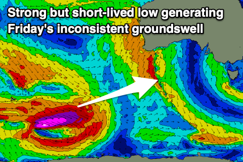
As touched on last week, a stream of east-southeast tracking frontal activity taking place to the south-west of Western Australia from yesterday through the coming days should generate some OK pulses of swell. The first and least consistent increase through Friday has already been generated by a polar low at the head of the frontal activity, with a fetch storm-force to hurricane-force W-W/NW winds generating a decent increase in size through Friday to 3ft to possibly 4ft across Middleton, tiny on the Mid Coast.
The secondary, more patchy and weaker activity looks to generate a secondary pulse for Saturday morning to a similar size, easing through the day and smaller Sunday.
Winds on Friday morning look variable offshore ahead of S/SE sea breezes, N/NE tending N/NW Saturday, providing a great day of surf.
Sunday will be great as well as the swell fades with fresh to strong N/NW-N winds.
Looking term, we’ve got a good run of moderate + sized W/SW groundswell under winds from the north-western quadrant, but more on this Wednesday.