Trickier, less reliable period

South Australian Forecast by Craig Brokensha (issued Wednesday July 23rd)
Best Days: South Coast today, South Coast tomorrow, Monday and Tuesday South Coast
Features of the Forecast (tl;dr)
- Easing surf tomorrow with mod-fresh N winds
- Inconsistent mix of SW groundswell and mid-period W/SW swell buiding Fri PM, holding Sat
- Strong NE winds Fri, strengthening W/NW tending W/SW Sat
- Building windswell late Sat on the Mid, peaking Sun with strong SW winds
- Mid-period S/SW swell building Sun down South, easing Mon with N/NW-NW winds
- Small-moderate sized, inconsistent SW groundswell Tue with N winds ahead of a shallow S/SE change
Recap
The Mid Coast saw another large, stormy event through yesterday with strong onshore winds and a large pulse of swell owing to a tight, strong mid-latitude low moving in from the west.
This low was high in the Bight and didn’t bring any swell to the South Coast until late, with Kangaroo Island blocking most of the energy, but this morning we’ve got better 3-4ft waves with a cross-offshore wind and lumpy conditions. The Mid is back to 2-3ft but wind affected and not great.
This week and next (Jul 24 - Aug 1)
The surf will continue to drop tomorrow in the wake of the strong low clearing to the east, and with this we should see winds shifting N’ly tomorrow with fading 2ft to occasionally 3ft sets, tiny and wind affected inside the gulf.
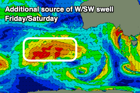
Into Friday, a mix of long-range SW groundswell and mid-period W/SW swell are expected to build, strongest later and into Saturday.
The source of the SW groundswell was a distant but healthy stream of polar frontal systems near and east of the Heard Island region, with the remnants of this projecting towards Western Australia yesterday evening, generating an additional W/SW swell arriving around the same time.
The Mid Coast should increase to a slow 1-2ft Friday afternoon, holding Saturday, fading Sunday.
The South Coast should see 2ft to occasionally 3ft sets off Middleton during the same timeframe with winds
Local winds are tricky though and will only favour selected spots with strong NE breezes on Friday, shifting W/NW to W/SW through Saturday while strengthening as a slow moving mid-latitude low moves in from the west.
This low will add some localised windswell to the mix for later Saturday but more so Sunday but with strong SW winds.
The southern flank of the low is expected to generate a weak fetch of S/SW winds in our southern swell window Sunday, kicking up a moderate sized S/SW swell for the afternoon down South, easing Monday from 3ft+ as winds shift around to the N/NW-NW.
Into the afternoon but more so Tuesday morning, a new, long-range groundswell is due, generated by a strong but distant and short-lived polar low that’s currently just west of the Heard Island region. Swell from this source looks unlikely to top 2ft to occasionally 3ft across Middleton with tiny waves inside the gulf under morning N/NE winds ahead of a shallow S/SE change.
Longer term, a better SW groundswell is on the cards for later week, generated by a strong polar low east of the Heard Island region but more on this Friday.
Comments
https://www.facebook.com/share/r/1B1GhuHf2b/
This algae bloom is out of control. In addition to fish and marine deaths there have been multiple reports of surfers getting sick after surfing on the mid coast on Sunday. They experienced flu type symptoms - shortness of breath, sore throat, aching muscles etc. that lasted several days. The south coast appears to be cleaner now.
Thanks for the intel.