Large, windy west swell tomorrow

South Australian Forecast by Craig Brokensha (issued Monday July 21st)
Best Days: South Coast today and later tomorrow, South Coast Wednesday and Thursday, Monday South Coast
Features of the Forecast (tl;dr)
- Large W/SW swell building tomorrow across the Mid (later South Coast), easing Wed
- Strong W/NW winds tomorrow, fresh to strong NW Wed
- Smaller W/SW swell Thu with gusty N/NE winds
- Mix of small W/SW mid-period swell and inconsistent SW groundswell for Fri/Sat
- Strong NE winds Fri, W/NW tending strong SW Sat
- Building windswell Sat PM on the Mid, easing Sun with the swell peaking down South Sun
- Strong SW winds Sun
Recap
The South Coast was the pick on Saturday with strong, tricky winds that created unfavourable conditions across the Mid Coast, while yesterday was much better inside the gulf as winds eased and tended light NE through the morning along with a fresh pulse of mid-period swell to 2-3ft.
The South Coast was also great with plenty of size and all day offshore winds, smaller today but the pick of it as the Mid Coast comes in bumpy and wind affected.

Good waves on the Mid yesterday morning
This week and weekend (Jul 22 - 27)
The current swell will continue to fade into tomorrow, but an intense, deepening mid-latitude moving in from the Bight tomorrow will bring with it a large increase in W/SW swell.
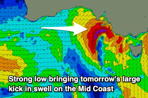
A tight fetch of gale to severe-gale W’ly winds are due to kick up 3ft to possibly 4ft of swell through the day across the Mid Coast, with the South Coast starting small before kicking into the afternoon to 4-5ft.
The low will dip south-east through tomorrow resulting in a rapid drop in swell through Wednesday, easing back from 2ft on the Mid Coast and 4ft+ down South.
Local winds will be poor for the Mid Coast tomorrow and strong from the W/NW, with Wednesday remaining similar and best down South with fresh to strong NW breezes.
We’re expected to see winds swing back cross-shore from the N/NE across the Mid Coast Thursday but by then the swell will be back to 1-2ft, best across the magnets on the South Coast.
Moving into Friday/Saturday, an inconsistent mix of small, background SW groundswell and mid-period W/SW swell are due to fill in.
The long-range SW groundswell is being generated by a distant and not overly significant polar frontal progression that’s currently around the Heard Island region, while the mid-period W/SW energy looks to be generated by the remnants of this progression pushing up and towards Western Australia in a weekend form.
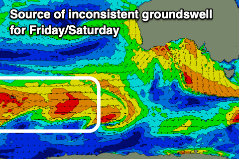
The SW groundswell only looks to be 2ft or so across Middleton with the W/SW energy coming in more around 1-2ft through Friday/Saturday.
Winds are tricky thanks to a slow moving mid-latitude low moving in from the west, with tricky, strong NE winds due Friday, shifting W/NW Saturday ahead of a stronger SW change into the afternoon as the low moves in.
Some localised windswell is likely from the low moving across us later Saturday on the Mid and larger down South Sunday but with strong SW winds. Monday should see a rapid improvement in conditions as winds shift back NW, but we’ll have a closer look at this Wednesday.