Large swells due later week
South Australian Forecast by Craig Brokensha (issued Monday July 14th)
Best Days: South Coast today and tomorrow, Mid Coast for the keen early tomorrow morning, South Coast Wednesday morning, both coasts Friday (Mid Coast early), South Coast Saturday and Sunday, possibly Mid Coast Sunday afternoon
Features of the Forecast (tl;dr)
- Easing surf tomorrow with W/NW winds
- Smaller Wed AM ahead of a late kick in size under strengthening NW winds
- Mod-large SW groundswell Thu with SW winds, possibly tending W/NW for a period down South
- Large W/SW groundswell Fri with early E/NE-NE tending moderate N/NE then fresh N/NW winds on the Mid, freshening N-N/NW down South
- Mod-large reinforcing W/SW groundswell Sat with Strong NW tending W/NW winds
- Mod sized W/SW swell Sun on the Mid, easing down South with W/NW tending N/NW winds
Recap
Saturday morning was the pick for the Mid Coast with early light winds and doable 2ft sets for the keen, while the South Coast offered great waves with a mix of swells, strongest through the afternoon under offshore winds.
Yesterday was a bit windier and smaller, with a cold front passing through, bringing a fresh pulse of energy this morning. Sets to 4ft+ are breaking on the South Coast with offshore winds, small and wind affected across the Mid Coast.
This week and weekend (Jul 15 - 20)
Today’s mid-period swell will back off into this afternoon, further tomorrow with light, local offshore winds due, holding from the W/NW most of the day down South. The Mid will be cleaner but easing from a slow 1-2ft with 3ft sets off Middleton.
A low point in swell is expected Wednesday morning but it will only be temporary, with the afternoon seeing an increase in mid-period swell thanks to a strong frontal progression pushing close towards us tomorrow, weakening on approach.
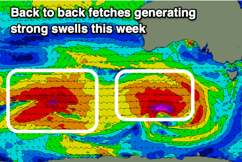
This first storm will shed off a significant frontal progression that’s currently taking place across the Heard Island region, with the progression due to continue east-northeast, under the country this week, bringing with it multiple pulses of moderate to large W/SW-SW groundswells.

We may see the first pulse arriving late Wednesday but Thursday is much more reliable with it arriving from a SW direction.
The source will be a great fetch of gale to severe-gale W/SW winds due to be generated well south of Western Australia today, producing solid 4-5ft+ waves across Middleton Thursday morning with 1-2ft sets on the Mid Coast.
Strengthening NW winds are due on Wednesday ahead of the swell, with Thursday seeing pre-dawn NW winds giving into a SW change around dawn. This isn’t ideal at all, though winds are due to ease and possibly tend W/NW for a period down South. We’ll review this on Wednesday.
Friday however looks very interesting, with a secondary front moving up through the Bight through Wednesday expected to come in similar in strength to the first swell generating low, but broader in scope.
We should see this generating a larger W/SW groundswell for Friday, peaking through the morning 6ft across Middleton with 2-3ft waves on the Mid Coast, and with the swell generating front moving through Thursday (bringing those SW winds), it looks to clear at the peak of the swell.
This should bring dawn E/NE-NE tending N/NE winds on the Mid Friday morning, fresher N/NW into the afternoon and best early, with freshening N-N/NW winds across the South Coast. Expect excellent conditions and surf for the experience.
Stronger NW tending W/NW winds are due on Saturday as the swell from Friday eases. The easing trend will be buffered by moderate to large, reinforcing W/SW groundswell that’s due to be generated by a final frontal system moving under Western Australia Thursday.
Middleton looks to hold 4-6ft with the Mid Coast also offering 2ft+ waves, though the remnants of this progression pushing in later could possibly kick the Mid Coast to 2-3ft later, though Sunday is a better chance of this.
Conditions unfortunately look to remain onshore Sunday for the Mid, though improving with a W/NW tending N/NW breeze, fun down South with easing 3-5ft waves.
Longer term the outlook is a little mixed with a strong mid-latitude low expected to push in from the west early next week, more on this Wednesday.

