Tons of swell for the weekend with options on both coasts

South Australian Forecast by Craig Brokensha (issued Friday July 11th)
Best Days: Today South Coast, tomorrow South Coast, Sunday morning South Coast, both coasts Monday (early Mid Coast)
Features of the Forecast (tl;dr)
- Moderate sized mid-period W/SW-SW swell this afternoon, easing tomorrow AM
- Moderate sized, reinforcing W/SW groundswell for tomorow PM, easing Sun
- Moderate N tending fresher N/NW winds tomorrow (N/NE early Mid Coast)
- Strengthening N/NW winds ahead of a mid-late PM W/SW change Sun
- Moderate + sized mid-period W/SW-SW swell Mon
- Early NE tending fresher N/NW winds on the Mid Mon, N/NW tending NW down South
- Strong S/SW winds Tue with easing surf
- Mod-large SW groundswell from Thu through next weekend
Recap
The Mid Coast kicked up again through the day yesterday with initially poor conditions improving a touch as onshore winds eased slightly and the swell pulsed to 3-4ft. Middleton was raw and bumpy early but improved across protected spots with easy 4ft+ sets.
Today we’ve got a drop in swell with choppy conditions across the Mid Coast, cleaner down South with a little less size to 4ft.
A new pulse of mid-period SW swell is due this afternoon down South, generated by a strong cold front passing under us, with winds due to hold from the W/NW.
This weekend and next week (Jul 12 - 18)

This afternoon’s increase in mid-period W/SW-SW swell is due to peak overnight and ease slightly into tomorrow morning.
The earlier stages of the frontal system linked to the mid-period swell generated a great fetch of W/NW gales to the south-west of Western Australia mid-week and this should produce a reinforcing groundswell for the afternoon.
All in all Middleton looks to hold around 3-4ft tomorrow morning, kicking to a more solid 4ft into the afternoon with the groundswell, while the Mid Coast holds 2ft.
A drop in size is then due Sunday from 3-4ft and 2ft respectively across the South and Mid Coasts, with local winds looking best tomorrow. A moderate N’ly wind will freshen out of the N/NW through the day, creating excellent conditions for the South Coast, N/NE early on the Mid but still bumpy and wind affected.

Sunday morning will be best down South with a strong N/NW breeze, giving into a strong W/SW change mid-late afternoon, so surf before then.
Sunday’s change will be attached to another cold front moving across the region, with a fetch of strong to sub-gale-force W/SW-SW winds attached to it, bringing another moderate + sized increase in mid-period swell for Monday.
The Mid Coast looks to kick back to 2-3ft with 3-5ft sets across Middleton as winds ease off and tend variable through the morning. The Mid looks to see variable NE winds early before shifting N/NW and increasing, all day offshore from the N/NW tending NW down South.
Tuesday will see the surf easing as a trough brings a S/SW change, bringing an end to the run of clean conditions.
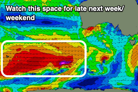
Longer term, we’re looking at a significant polar frontal progression firing up around and east of the Heard Island region from this weekend, with multiple storms expected to generate an expansive, elongated fetch of severe-gale westerly winds, with embedded storm-force winds likely.
This looks to generate a moderate to large run of inconsistent, long-period SW groundswell from Thursday next week, with the largest increase due Friday/Saturday.
We’ll have a closer look at this on Monday, have a great weekend!