Plenty of swell but wind for the Mid Coast

South Australian Forecast by Craig Brokensha (issued Wednesday July 9th)
Best Days: Keen surfers Friday, beaches Saturday morning, keen surfers Tuesday and Wednesday mornings
Features of the Forecast (tl;dr)
- New, large W/SW groundswell for tomorrow, peaking in the PM, easing Fri
- Strong W/NW winds tomorrow, fresh W/NW Fri, easing through the day
- Mix of building W/SW-SW swells Sat with fresh N/NW winds, easing Sun with strong N/NW tending NW winds ahead of a late change
- Moderate sized SW swell Mon with NW tending W/NW winds
- Larger surf due through the middle to end of next week
Recap
Another large, stormy swell built across the Mid Coast through yesterday with lots of erosion into the afternoon, settling this morning as winds shifted more north of west.
The South Coast was tiny and wind affected yesterday, much better today with a lift in new W/SW-SW groundswell under cold, offshore winds. Winds will remain strong from the N/NW all day, shifting onshore after dark, so make the most of it.

Great surf this morning
This week and next (Jul 10 - 18)
Today’s mix of W/SW-SW groundswell and mid-period energy are due to ease into tomorrow, but a reinforcing mix of large W/SW swells are due through the day, generated by a strong frontal system that projected up towards Western Australia through yesterday and is now moving through the Bight, across us while weakening this evening.
This will bring the change in winds which look to start strong from the W/SW pre-dawn, quickly reverting back to the W/NW by the time first light comes, persisting all day.
The west swell will be biggest across the Mid Coast, building to 4ft again with the strengthening W-W/NW winds, while the South Coast should come in around 3-5ft.
A drop in swell is due through Friday under gusty W/NW winds (abating through the day) and then offshore from the N/NW Saturday stronger N/NW tending NW Sunday ahead of an evening change.
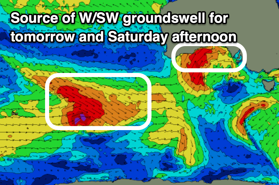
Swell wise, some new mid-period SW swell is due Saturday morning with a stronger groundswell for the afternoon, generated by a healthy frontal system currently north-east of the Heard Island region.
A great fetch of W/NW gales are due to weaken once passing under the country tomorrow and Friday, generating two separate pulses of swell.
The Mid Coast shouldn’t drop below 2ft Saturday and Sunday morning, with the South Coast building from 3ft+ Saturday morning to 4ft through the afternoon, easing Sunday from 3-4ft.
With the local winds, the Mid Coast will be bumpy and not great, best down South.
The front passing through Sunday afternoon/evening, bringing a late wind change is expected to bring some new, sizey swell for early next week, but beyond this, a more significant stream of frontal activity from south-west of Western Australia looks to bring a large run of W/SW groundswell with winds from the north-western quadrant. More on this Friday.