Cold, windy weekend ahead

South Australian Forecast by Craig Brokensha (issued Wednesday May 4th)
Best Days: Tomorrow morning South Coast, Saturday protected spots South Coast
Features of the Forecast (tl;dr)
- Small mid-period S/SW swell easing tomorrow with strengthening N/NE tending N winds
- Tiny Fri with strong N/NW tending W/NW winds (building windswell on the Mid Coast)
- Moderate to large sized W/SW swell Sat AM, with a stronger SW swell for the PM
- Strong W/NW-NW winds
- Large S/SW swell Sun with strong SW winds
- Easing swell Mon with strong SW winds
- Easing S'ly swell Tue with mod-fresh W/SW winds, possibly W/NW for a period around Victor early
Recap
Yesterday was a blown out mess across the South Coast with tiny, lumpy waves on the Mid, cleaning up through the day.
Today we’ve got great, glassy conditions inside the gulf with tiny 1ft+ sets, while the South Coast is improving and lumpy to 2-3ft.
This week and weekend (Jun 5 - 8)
Looking at the end of the week, the current mix of weak swells for the South Coast will clean up and ease through tomorrow, with a mid-period S/SW swell dropping from 2ft+ across Middleton in the morning (tiny Mid Coast).
Winds will be out of the N/NE, fresh in nature and slowly strengthening while shifting more N’ly into the afternoon, with Friday seeing strong N/NW winds, shifting more W/NW through the day.
There’ll be nothing left to surf down South on Friday while the Mid Coast should see building levels of tiny windswell.
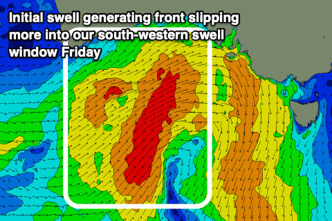
Now, looking at the weekend and the evolution of the low and swell pulses have changed a little, with the mid-latitude low that’s due to move in from the west now expected to arrive a little earlier.
The low is also due to be a little weaker, with a fetch of strong W/SW winds pushing in through the Bight tomorrow, dropping more into our south-western swell window on Friday.
The southward shift will result in the Mid Coast only likely coming in around 3ft or so Saturday morning, while a secondary frontal system moving up and into us through the day might kick up 3-4ft of swell later in the day, easing from 3ft+ Sunday morning.
For the South Coast, the fetch over the coming days should produce a good, building W/SW tending SW swell Saturday to 4-5ft, while the secondary front pushing up into the afternoon may generate more size later but more so Sunday to 5-6ft or so.
Unfortunately it looks like winds will become a problem as the swell peaks for the South Coast Sunday, with the low stalling a bit east and south of us, with strong W/NW-NW breezes due Saturday, shifting strong SW Sunday.
These SW winds will persist Monday across all locations thanks to the stalling low, weakening into the late afternoon and then likely tending more W/SW-W/NW on Tuesday.
Unfortunately by then the bulk of the strong swell energy will be gone, with localised levels of low-period surf due to ease out of the S/SW into the middle of the week.
With this in mind, tomorrow and Saturday look to be the pick of the period. Check back here Friday for any improvement to Sunday/Monday’s outlook, but this looks unlikely.