Great three days for the South Coast

South Australian Forecast by Craig Brokensha (issued Friday May 30th)
Best Days: South Coast tomorrow, Sunday and Monday
Features of the Forecast (tl;dr)
- Inconsistent S'ly groundswell tomorrow AM, easing slowly, further Sun
- Light to mod N/NE-NE tending N/NW winds west of Victor tomorrow PM, E/NE to the east
- Light to mod N/NE tending N/NW Sun
- Small, inconsistent SW groundswell building later Sun, easing Mon with N/NW tending variable winds
- Tiny W/SW swell for Mon/Tue
- Smaller down South Tue with early W/NW tending SW then strong S/SE winds
- Fresh E/NE-NE winds Wed with a small increase in mid-period S/SW swell through the PM
- Easing S/SW swell Thu with strengthening N/NE-NE winds
Recap
Our expected easing winds swinging offshore across the South Coast didn’t eventuate yesterday, while today it has and we’ve got lumpy, fun 3ft sets out of the south with workable conditions for the keen. The Mid Coast has slowly eased in size, tiny and a little lumpy yesterday, nice and clean today.
This weekend and next week (May 31 - Jun 6)
The next three days look great for the South Coast with offshore winds and fun amounts of swell energy, strongest and biggest tomorrow morning.
This will be thanks to a good pulse of S/SW groundswell filling in, generated by a fetch of gale to severe-gale SW winds to the south-west of Tasmania yesterday afternoon and evening. This fetch is now east of Tasmania and out of our swell window, but a trailing fetch of weaker W/SW winds will slow the easing trend a touch into Sunday morning.
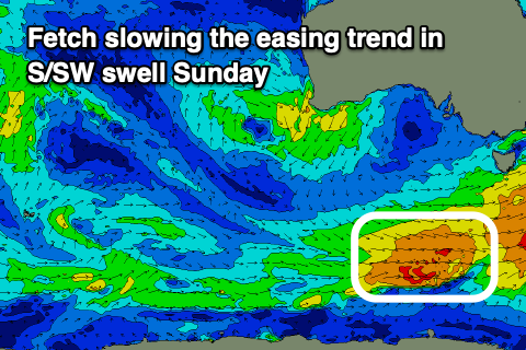
Middleton should offer inconsistent but good 4ft sets tomorrow morning, easing through the day with Sunday dropping from an even less consistent 3ft. The Mid looks tiny owing to the source of the swell and blocking effects of Kangaroo Island.
Also in the mix later Sunday and Monday morning will be a long-range SW groundswell generated in our far swell window, to the south and south-east of South Africa earlier this week.
It will be extremely inconsistent but should keep 2-3ft sets hitting Middleton, tiny inside the gulf.
Now, looking at the local winds, a N/NE-NE offshore is due tomorrow, likely tending variable N/NW west of Victor through the afternoon, E/NE to the east.
Sunday should then see N-N/NE tending N/NW winds across all locations, N/NW tending variable Monday. This will create a great few days of surf.
Into Tuesday, early W/NW winds will shift SW and then strong S/SE into the afternoon as a trough slides through. There might be a tiny 1ft wave in the gulf from a weak fetch of W/SW winds to the south-west of Western Australia today, but it won’t generate any meaningful size.
The change in winds now looks temporary as an approaching mid-latitude low from the west swings winds back to the fresh E/NE-NE on Wednesday, with stronger N/NE-NE winds Thursday.
Swell wise, a weak fetch of SW winds from a frontal system attached to the trough is due to bring some weak energy Wednesday afternoon and Thursday morning but only to 2ft+ or so.

The mid-latitude low itself isn't expected to generate any swell for us, with it sitting too far north of our swell window, off Western Australia originally, then weakening while moving through the Bight and staying north.
It might drag in a secondary system next weekend but again not ideal for swell generation at all.
Otherwise some very inconsistent long-range SW groundswell looks to fill in next weekend (Sunday), with better swell possibilities into the following week. More on this Monday, have a great weekend!