Make the most of the weekend and Monday

South Australian Forecast by Craig Brokensha (issued Wednesday May 28th)
Best Days: Keen surfers Friday, beaches Saturday morning, keen surfers Tuesday and Wednesday mornings
Features of the Forecast (tl;dr)
- Moderate sized, mid-period S/SW swell tomorrow and Fri
- Pre-dawn S winds tending variable offshore from dawn across the South Coast ahead of afternoon sea breezes tomorrow and Fri
- Inconsistent S'ly groundswell Sat AM, easing, smaller into Sun
- Light to mod N/NE-NE tending E/NE winds Sat
- Light to mod N/NE tending N/NW Sun
- Small, inconsistent SW groundswell building later Sun, easing Mon with N/NE tending variable NW winds
- Smaller Tue with early W/NW tending strong S winds
- Small swells later next week with E/NE-NE tending SE winds Wed, gusty NE winds
Recap
Monday’s significant, stormy swell backed off through yesterday along with the local winds, leaving choppy, dropping 3-4ft waves across the Mid Coast while the South Coast was chunky but also onshore.
Today winds and conditions have improved across the Mid Coast but the swell is weaker and smaller with fading 1-2ft sets inside the gulf, poor and 4ft or so across the South Coast under a fresh S’ly wind.
This week and next (May 29 - Jun 6)
As touched on Monday, winds should continue to ease and improve across the South Coast tomorrow but with S’ly winds blowing right up until dawn, only tending variable N/NE from daylight there’ll be a lot of lump and noise in the mix.
Swell wise, a new mid-period S/SW swell to the 3ft range across Middleton is due and conditions will likely be best later morning/into the middle of the day before sea breezes kick in.
Friday looks to play out similarly with the background S/SW energy likely holding 3ft across Middleton, lumpy early and improving ahead of weak sea breezes.
The weekend looks much more reliable with the arrival of a new S’ly groundswell Saturday under a N/NE-NE offshore (E/NE into the afternoon).
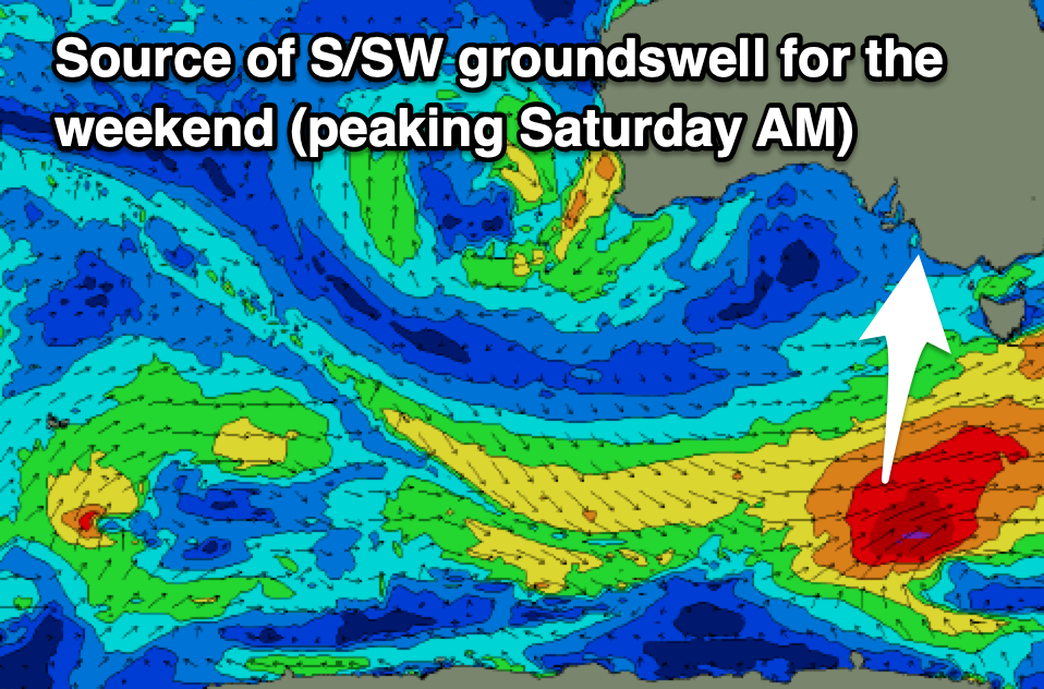
This swell will be generated by a strengthening polar frontal progression to the south-west of Tasmania tomorrow, with a fetch of gale to severe-gale W/SW-SW winds due to fire up late in our swell window.
It’ll be inconsistent but Middleton should come in at 3-4ft Saturday morning (tiny on the Mid thanks to the southerly direction), easing through the day and then down from 2-3ft Sunday morning.
Winds on Sunday look great all day and N/NE tending N/NW with Monday playing out similarly.
Now, later in the day Sunday but more so Monday morning, a new, long-range and inconsistent SW groundswell is due, generated by a strong polar low that fired up to the south of South Africa earlier this week, in our far swell window. The low weakened while projecting east and with this we’re only expecting very inconsistent 2-3ft sets across Middleton later Sunday and into Monday morning (tiny Mid Coast).
With the favourable conditions and fun sized swell, Sunday and Monday are worth making the most of before a trough brings strong S’ly winds through Tuesday, swinging more E/NE-NE every morning thereafter. No major swell is due with a meandering mid-latitude to the west of Western Australia and high pressure to our south blocking our main swell windows.
This should change into the following week, though no major storm activity is due at this stage. More on this Friday.
Comments
Had a splash on the mid this a m .. water was noticeably cooler and was well churned up.... All good signs for death of the algae... Look forward to satellite pics in a week or so when clouds pis off see if it's been broken up etc.. fingers crossed
That is a positive sign.