Large, stormy surf this afternoon, abating over the coming days

South Australian Forecast by Craig Brokensha (issued Monday May 26th)
Best Days: Mid Coast Wednesday morning, Saturday and Sunday down South (likely Monday as well)
Features of the Forecast (tl;dr)
- Large, stormy W swell this afternoon with near-gale-force NW tending W/NW winds
- Mix of easing stormy swell and groundswell tomorrow with strong SW winds (W/NW for a period South Coast)
- Fresh S winds Wed with easing swell (S/SE in the AM on the Mid)
- Easing surf Thu with NE tending S/SE winds down South
- Moderate sized S/SW groundswell building Fri PM, holding Sat AM, easing
- E-E/NE tending S/SE winds Fri, N/NE tending E/NE Sat
- N/NE tending N/NW winds Sun
Recap
Friday’s strong groundswell eased into Saturday and the South Coast was the pick with much smaller, easing surf from an inconsistent 3ft across Middleton, small and wind affected across the Mid Coast.
Yesterday a new pulse of W/SW swell maintained 3ft waves across Middleton with decent conditions before winds strengthened into the afternoon.
Today, we’ve got building levels of NW windswell as the slow moving but intense mid-latitude low starts pushing in from the west. It’s been delayed a little and with that the timing of the stormy energy has been shifted more to the afternoon, and it doesn’t look quite as large as expected on Friday. Read on below for more details.
This week and weekend (May 27 - Jun 1)
The strong cold-outbreak that’s currently moving in from the west has stalled a little and with this we’re still seeing N/NW winds across the regions this morning.
These will shift more NW and then W/NW during the day while strengthening further, kicking up a solid stormy windswell across the Mid Coast though not to the size expected on Friday. We should see the Mid Coast still reaching 4-5ft this afternoon with stormy waves on the metro beaches with the South Coast building to 4-5ft but with blustery conditions.

The low will moves east through tomorrow and with it we’ll see winds weaken but remain strong from the SW, with early W/NW breezes likely around Victor.
Swell wise the stormy energy should be abating along with large levels of groundswell, easing from 3-4ft on the Mid Coast with the South Coast easing back from 4-5ft.
Winds will swing more S’ly as high pressure slides in from the west on Wednesday but with easing levels of swell continuing across both regions, likely only 1-2ft on the Mid Coast with a morning S/SE breeze, poor down South.
The high will be fairly slow moving, but shift east through the end of the week and this should see winds ease back and swing to the NE through Thursday morning down South but with lumpy, easing 3ft+ waves across Middleton (tiny Mid Coast).
Into Friday, the local winds are a touch dicey and only possibly shifting E-E/NE through the morning down South, with the weekend coming in much better along with some good S/SW groundswell.
A strengthening polar front on the southern flank of the high is due to generate fetches of gale to severe-gale W-W/NW winds to the south-west of Tasmania, producing a moderate sized S/SW groundswell for Friday afternoon / Saturday morning.
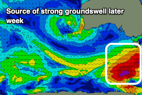
Building sets to 4ft are due across Middleton on Friday afternoon, easing from a similar size Saturday morning, with the Mid Coast due to remain tiny.
Local winds Saturday look great with a N/NE tending weak E/NE breeze, all day offshore Sunday and N/NE tending N/NW.
Longer term the outlook is quite slow with generally smaller surf, apart from a distant SW groundswell later Sunday but more so Monday. More on this Wednesday.
Comments
Noticed a large ship slowly sailing southwards through the gulf pre-dawn this morning.
Wonder if it's this bulk carrier, MSC Archimidis? Seems to be an unusual track given the incredible stormy conditions on offer.
Yeah was checking Christie's at dawn... Thought it was a cruise liner, had lights on etc... was a big one...
There was a story on the ABC news (Vic) on Saturday night about the algae bloom on the SA coast. Was terrible to see big rays, fish and other sea life washed up on your beaches. Not to mention the effect on surfers with coughing etc. I had read about what has been occurring but to see the footage really brings it home. Hopefully this big storm system and swell flushes out the region helps get things back to normal.
Just did the drive along the mid, it's like Rundle Mall, sight seers everywhere.
Waves crashing into the cliffs at Seaford sending yellow sand out into the lineup. Waves hitting the wall at Moana sending spray across the road. Pedlars Creek almost bursting its banks.
At Southport the sand spit is completely under water. White water to the horizon.
Wonder if Myponga still works on these stormies. Great memories from long ago surfing there.
I reckon wind needed to be a bit more WSW