Good today, large and stormy early next week

South Australian Forecast by Craig Brokensha (issued Friday May 23rd)
Best Days: Today both coasts, tomorrow South Coast, protected spots South Coast for the keen Monday, possibly Mid Coast Wednesday morning
Features of the Forecast (tl;dr)
- Easing SW groundswell tomorrow with strengthening N-N/NW winds (N/NE early on the Mid Coast)
- Moderate sized W/SW swell Sun along with some building NW windswell with strenthening N/NW winds
- Large, stormy swell Mon with strong NW tending W/NW-W winds
- Moderate + sized SW groundswell building down South during Mon
- Large stormy S/SW swell Tue with strong SW winds, easing and tending S/SW
- Easing surf Wed with S/SE winds
- Moderate sized S/SW swell pulses Thu through Sat AM with morning E/NE-NE winds down South ahead of sea breezes
Recap
Our strong pulse of W/SW swell pulsed later Wednesday but yesterday was the pick of it with all day offshore winds and consistent 2-3ft waves all day.
Later in the day some new, long-period SW groundswell start to show and this is peaking today with waves holding 2-3ft inside the gulf with slightly less favourable conditions (still really fun), while the South Coast is offering inconsistent, clean 4-6ft sets. Winds are due to tend variable NW this afternoon, keeping conditions good across both regions.

Pumping yesterday morning!
This weekend and next week (May 23 - 30)
Today’s peak in large SW groundswell is due to ease through tomorrow with 3-4ft sets expected off Middleton, smaller through the day with the Mid Coast easing back from 1-2ft (2ft magnets).
Local winds will quickly strengthen out of the N/NW, shifting more NW into the afternoon. The Mid may see early N/NE winds but it will be wind affected and quickly deteriorate.

Into Sunday, we’ve got a new pulse of moderate + sized W/SW swell, generated by a healthy mid-latitude low that’s currently just under Western Australia.
A fetch of strong to gale-force winds should produce a good pulse of W/SW swell energy to 2-3ft on the Mid Coast again with 3ft waves across Middleton, but strengthening N/NW winds ahead of a significant cold outbreak will likely kick up similar levels of N/NW windswell.
Now, as touched on in Wednesday’s outlook, we’re set to see a strong polar front projecting northwards, towards the Bight today and tomorrow.
We’ll see a great fetch of gale to severe-gale SW-S/SW winds projected north, obliquely to our swell window before the low then slowly moves east and across us through Sunday/Monday.
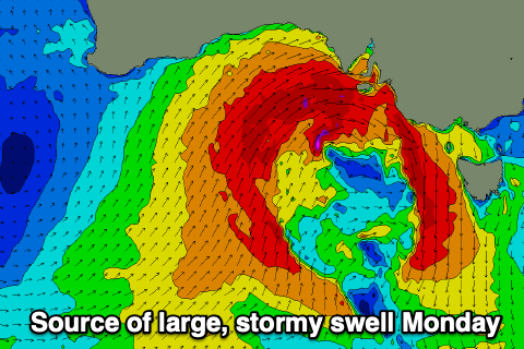
With fetches of gale to severe-gale W/SW winds pushing slowly east towards us we’re looking at a significant increase in large W/SW groundswell and localised stormy swell through Monday, likely peaking to 4-6ft across the Mid Coast with plenty of metro options under strong NW tending W/NW-W winds. This will hopefully mix up the gulf enough to kill off the algal blooms (fingers crossed).
The South Coast should see building levels of SW groundswell from the earlier stages of the polar frontal system, with the localised windswell likely being blocked by Kangaroo Island. Building surf to 4-5ft is due through the day, if not a little stronger later but with those, strong, tricky winds, while come Tuesday as the low moves east across us, larger 4-6ft waves are due but with strong SW tending weaker S/SW winds.
The Mid Coast will start to ease in size but still likely be 4ft or so, smaller Wednesday and easing from 1-2ft as winds shift S/SE.
Winds should slowly improve for the South Coast from Thursday onwards as high pressure slowly shifts in from the west, and swell wise, persistent polar frontal activity behind the mid-latitude low early week should generate moderate sized pulses of energy. Morning E/NE-NE winds are due with the best pulse due Friday afternoon/Saturday morning, but more on this Monday. Have a great weekend!
Comments
some crazy shit is going to wash up on the mid and metro beaches!
Stinky puffer fish at Middleton today
got my ear plugs on the ready
We got the edge of that system and it was still hectic gale force winds.
You lot are getting the core of it and the part that made the swell 5m plus here today.
Hectic.
Amazing seeing how this system moves across land after making landfall in Adelaide, but then once it hits the Tasman, reintensifies and sends a possible Thundercloudesque swell to the NE.
Weird one this one. Just sitting off the coast... The tip of KI is copping it now.
insane at Canunda today, solid as, howling offshore.
Back in the day i played for the Port Elliot bloods. The Mudlarks were a damn tough challenge. Copped a few bruises from them. If only they got waves there.
68kt (126km) WNW gust at Neptune Island
Things are getting serious out there, new buoy is going to be tested.
Hold!!
Remarkable buoy readings on WA south coast overnight!
They might want to move that excavator at Christies :)