Best over the coming days

South Australian Forecast by Craig Brokensha (issued Wednesday May 21st)
Best Days: This afternoon Mid Coast, tomorrow and Friday both coasts, Saturday South Coast
Features of the Forecast (tl;dr)
- Moderate to large sized W'ly swell building later today, peaking overnight, easing tomorrow
- Local offshore winds tomorrow AM, with weak PM sea breezes
- Large, powerful SW groundswell Fri AM (possibly showing later tomorrow), easing into the PM and Sat
- N/NW tending W/NW winds Fri down South, NE tending NW on the Mid without much strength
- Strengthening N/NW tending NW winds Sat (N/NE early Mid)
- Mod-large W/SW swell Sun with strong N/NW winds (building windswell in the Mid Coast)
- Large, stormy mix of swells Mon/Tue with gale-force NW tending W/SW winds Mon, strong but easing S/SW Tue
Recap
The Mid Coast was tiny and wind affected yesterday, great down South with offshore winds and an easing 2ft+ of swell across Middleton.
Today is nice and clean again on the South Coast with 1-2ft sets, tiny and to 1ft inside the gulf. Some new W/SW swell is due into this afternoon, with the Mid Coast expected to reach 2ft to possibly 3ft weak sea breezes.
This week and weekend (May 22 - 25)
This afternoon’s increase in W/SW groundswell was generated by a strong mid-latitude low pushing up and under Western Australia, with it due to produce 2ft to possibly 3ft sets across the Mid Coast later today, easing back from 2ft+ tomorrow morning with Middleton only due to see inconsistent 3ft sets thanks to the blocking effects of Kangaroo Island.
Local winds tomorrow look great with light, local offshore breezes ahead of relatively weak sea breezes.
Now later in the day we might see the fore-runners of our large SW groundswell showing across the regions, though Friday is still expected to reveal the peak in energy.
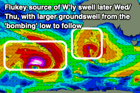
The ‘bombing’ low linked to the swell is currently weakening to the south of Western Australia while still generating fetches of W/NW gales.
Before the low weakened we saw a tight, very intense fetch of storm to hurricane-force winds, abating slowly through yesterday as the low expanded in scope and pushed east.
This has generated a large, long-period SW groundswell with it expected to peak Friday morning to 6ft+ across Middleton with 8ft sets on the deepwater reefs, and 2ft on the favourable parts of the tide across the Mid Coast.
Local winds look great for the South Coast and N/NW tending W/NW with early NE winds across the Mid Coast before shifting variable NW into the afternoon.
The swell is due to ease into Saturday back from 3-4ft across Middleton with strengthening N/NW tending NW winds (N/NE early on the Mid but tiny).
This strengthening wind will be ahead of a significant cold outbreak across the state, with a deep polar front due to project from the polar shelf towards the Bight through Friday/Saturday, moving across us slowly through Sunday/Monday.
Ahead of the storm proper, Sunday looks to see a moderate + sized W/SW swell from an initial front passing under WA towards the Bight Thursday/Friday, with the Mid Coast due to come around 2-3ft but with strong N/NW winds, whipping up some localised windswell.
The South Coast looks to see 3ft+ waves across Middleton, tricky with the strong offshore winds but clean and lined up.
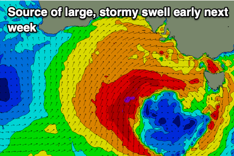
Come Monday, the low will move across us proper, bringing gale-force NW tending W/SW winds and a large increase in stormy windswell across both the Mid and South Coasts.
The size is still up for grabs with GFS stalling the progression longer than ECMWF though we’re probably looking at 4-5ft waves inside the gulf and 10ft stormy surf developing down South later and more so into Tuesday.
Strong S/SW winds look to create poor conditions Tuesday, likely tending more S’ly Wednesday but well review this Friday.
Comments
Finally a stormy...and some rain.. fingers crossed it does what "the experts " are saying... It breaks down the algal bloom
100% brother.
Ha!!! You took my prediction and posted it that gives me a feeling of well being knowing I can predict with the best of them. Unfortunately I believe the low will track lower than anticipated stalling the much needed rain to only be about 50% of what’s expected the good news is that means lighter wnw winds guiding the swell into the Gulf earlier than expected.
We all know a steadily active sea state with reinforcing swell after reinforcing swell is when the mid truly does its thing and there is at least a decent chance of this occurring late Monday or Early Tuesday.
Taking into account the models prediction of today’s increase looks to be lagging this also may happen with the Bomb low that will feed and reinforce the xxl WSW swell train due on Sunday Monday. Geez it looks that good North Haven could even light up ( by north haven standards lol not for real )
I have been observing and predicting since the late 80s and I am really excited about this coming event.
In any case wind affected or not I want lots of energy to hit the coast to try and break the stranglehold of this bloody nasty Karenia mikimotoi dinoflagellate has on our normally sublime coastline.
And like many I want answers to why it’s happened I’m not convinced it’s all to do with a 2.5 degree temperature increase, something ain’t sitting well with me. Just for the record I’m not into conspiracy theories either (Chinese ships etc) peace and above all love the stoke !!!
Hey Craig is the buoy fixed? I'm getting readings
Yep buoy is back up and running... Think last week it went back online..
Yep, back last week.
Willy weather calling 50 km. gale force NW-W winds from about lunchtime Sunday to lunchtime Monday. Then turning SW and slowly easing for the next few days. Might be the first stormy on the metro beaches for ages. So typical of around here, when you get a bit of size its absolute onshore crap. Nice today though.
Hope it does flush away the bloom, I've heard so many horror stories from KI and Yorkes, a complete catastrophic event, everything dead from sponges to birds and seals, unprecedented collapse of entire ecosystems. The media is downplaying it for tourism reasons imo.
Hope they doubled up on the moorings