Strong back to back swells this week

South Australian Forecast by Craig Brokensha (issued Monday May 19th)
Best Days: Today, tomorrow morning South Coast, later Wednesday Mid Coast, Thursday both coasts, Friday South Coast, Saturday South Coast
Features of the Forecast (tl;dr)
- Easing surf tomorrow with moderate N/NE tending NW winds
- Moderate to large sized W'ly swell building later Wed, peaking overnight, easing Thu
- Variable tending SW winds on the Mid Coast Wed, W/NW tending S down South
- Local offshore winds Thu AM, with weak SE sea breezes down South
- Large, powerful SW groundswell Fri, easing Sat
- N/NE tending N/NW winds Fri down South, E/NE-NE tending fresh N/NW on the Mid
- Fresh N/NW winds Sat (N/NE early on the Mid)
- Strong NW winds Sun with a building windswell across the Mid Coast
Recap
The weekend was mostly average across the South Coast with onshore breezes Saturday and some much needed rain, while yesterday saw improving but lumpy surf for the keen as winds shifted more E’ly. The Mid Coast offered small, mixed waves Saturday, cleaner yesterday and still holding 1-2ft.
Today the Mid is still 1-1.5ft for the keen while the South Coast was cleaner and a fun 3ft+ under cool, sunny skies.
This week and weekend (May 20 - 25)
Tomorrow looks great for the South Coast magnets with clean conditions and a small 2ft of swell across Middleton under moderate N/NE tending NW winds.
Surf the morning for the best of it.
A temporary low point is due Wednesday morning and a trough will bring light W/NW winds though shift S’ly around midday, with the Mid Coast seeing light SW breezes.
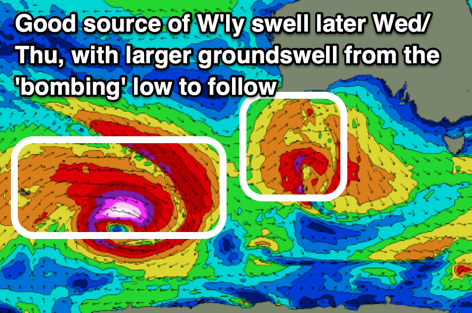
Into the afternoon, a good pulse of new W/SW groundswell is due, generated by a high riding mid-latitude low pushing under Western Australia today.
A great fetch of strong to gale-force W’ly winds through our western swell window, dipping quickly south-east through tomorrow while maintaining strength.
This quick south-east track isn’t ideal but the initial westerly fetch should generate a good kick in size to 2ft to possibly 3ft across the Mid Coast later in the day, peaking overnight and easing from 2ft+ on Thursday morning.
The South Coast will be inconsistent thanks to the westerly swell direction and blocking effects of Kangaroo Island with sets to 3ft due off Middleton.
Local winds on Thursday should swing E’ly across the Mid Coast and NE down South creating good conditions that will persist all day inside the gulf and go sea breezy down South.
Into Friday, we’ve got a large, powerful SW groundswell due, with the source being a ‘bombing low’ that’s currently deepening to the east of the Heard Island region.
As this system bombs and reaches an incredibly low central pressure of 926hPa, we’ll see a great but tight fetch of storm to hurricane-force W’ly winds generated in our far swell window, expanding while slowly weakening and moving east through this evening and tomorrow.
With the low maintaining severe-gale W’ly winds in our south-western swell window through tomorrow, only breaking down into the evening, we can expect a large sized, long-period SW groundswell from this source, peaking through the day Friday to 6ft+ across Middleton with 8ft sets on the deepwater reefs and inconsistent 2ft sets on the favourable parts of the tide across the Mid Coast.
Local winds look excellent for the South Coast and light to moderate N/NE tending N/NW with the Mid being best early under E/NE-NE breezes before freshening from the N/NW during the day.
Fresh N/NW winds are expected on Saturday (N/NE early Mid Coast) as the swell slowly eases, still 3-5ft during the morning on the South Coast and a choppy 1-1.5ft across the Mid Coast.
Sunday will see strengthening NW winds as the swell continues to fade, kicking up some stormy NW windswell across the Mid Coast. This may be followed by a large SW swell early next week from a deepening mid-latitude low moving in from the west, but more on this Wednesday.
Comments
Jeez big swell to hit the mid early next week!!! Biggest in a long time with 4-5 foot possible on the spring of the tides. Hopefully winds align this could be one of the best swell events in recent memory.
Solid yes but onshore.
Epic windswell