Best today and tomorrow

South Australian forecast by Craig Brokensha (issued Friday April 18th)
Best Days: Tooday both coasts, tomorrow South Coast (best morning), South Coast Thursday
Features of the Forecast (tl;dr)
- Easing swell Sat with freshening N/NW tending stronger W/NW winds late
- Building windswell across both coasts Sun with strong W/NW-tending W/SW winds
- Mod-large S/SW swell Mon AM, easing with strong but easing S/SW winds
- Mix of moderate sized SW groundswells building Tue PM, peaking later and into Wed AM
- Gusty SE tending S/SE winds Tue, moderate E/NE-NE Wed AM ahead of sea breezes
- Easing swell into Thu with N/NE tending W/NW winds, likely S Fri
Recap
The South Coast was the pick yesterday with inconsistent but good 2-3ft waves after a fun pulse in size Wednesday afternoon. Into the afternoon some new W/SW swell started to show, with it also kicking to 1-2ft on the Mid Coast but with onshore winds.
Today is the pick with clean conditions all around and 2ft surf on the Mid Coast with 3-4ft waves down South.
This weekend and next week (Apr 19 - 25)
Today’s W/SW swell will start to ease back through tomorrow, though slowed by the arrival of a reinforcing mid-period W/SW swell, generated by a small frontal system that slid south-west of Western Australia mid-week.
Middleton should still be 3ft with the Mid Coast coming in mostly around 1-1.5ft as winds freshen from the N/NW, tending W/NW later while strengthening further.
This will be ahead of a meandering low moving in from the west, with it expected to bring strengthening W/NW tending W/SW winds through Sunday as it stalls just west of us. A localised windswell will be whipped up to 2ft+ or so on the Mid Coast with building 4-5ft sets down South.
The low will move east into Monday while weakening but still bring strong S/SW winds that will shift more S’ly into the afternoon while slowly abating. The South Coast looks to remain poor and onshore with easing 4-6ft of localised swell, choppy and 2ft across the Mid Coast.
Moving into Tuesday and winds will remain gusty from the SE tending S/SE and we should see some new, long-range SW groundswell arriving into the afternoon, with a peak due Wednesday.
The source of the swell was a strong but distant frontal progression that started south of South Africa and travelled east towards the Heard Island region the last couple of days. Multiple fetches of severe-galeforce winds should produce an inconsistent but moderate sized SW groundswell for later Tuesday, peaking Wednesday.
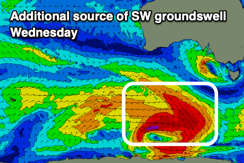
An additional, closer-range and more consistent SW swell is due to be in the mix Tuesday afternoon and Wednesday, generated by great, pre-frontal gale to severe-gale NW winds moving under the country on the weekend, with tighter severe-gale to storm-force W winds immediately following around the core of the low.
The Mid Coast looks to only reach 1.5ft later Tuesday and into Wednesday with Middleton coming in at a stronger 4ft on the sets.
Conditions won’t be perfect but doable for the South Coast Wednesday morning thanks to an E/NE-NE offshore, with Thursday coming in better as the swell eases under a N/NE tending W/NW breeze.
This will be ahead of a trough and S’ly change into Friday that looks to persist all next weekend, but we’ll have a closer look at this Monday. Have a great weekend!
Comments
the last hour more and more sets breaking at the dump... shame about the strong winds but it's not completely making a mess of the lines.