Average period with no great days of surf

South Australian Forecast by Craig Brokensha (issued Wednesday March 13th)
Best Days: This afternoon Mid Coast, Saturday morning South Coast, Sunday and Monday mornings South Coast for the keen
Features of the Forecast (tl;dr)
- Easing SW groundswell tomorrow with gusty SE winds
- Smaller Fri with gusty E/SE tending S/SE winds
- Moderate sized S/SE windswell building Fri, easing Sat
- Small, easing mix of swells Sat with variable tending E/NE winds ahead of SE sea breezes
- Smaller Sun with N/NE tending SE winds
- Small Mon with N/NE tending SE winds
- Strong S winds Tue with a building windswell, peaking Wed
- Moderate sized SW groundswell Wed with strong S/SE winds
Recap
Yesterday was average and onshore across the South Coast with tiny leftovers on the Mid, building a little into the afternoon around Victor but peaking today. The swell is back up to the 4ft range across Middleton (but onshore) with the Mid Coast coming in at a tiny 1ft, pulsing a little this afternoon to 1.5ft on the incoming tide.

Little sets showing this afternoon
This week and weekend (Mar 14 -17)
The coming period is a bit average with the swell due to fade as winds only improve for the South Coast once it's smaller on the weekend.
Today's SW groundswell is due to ease back through tomorrow, further Friday as winds create poor conditions on the South Coast. The Mid will be clean but tiny and unsurfable for most.
Easing 3-4ft sets are due across Middleton tomorrow morning with gusty SE winds, E/SE-SE on Friday morning, S/SE into the afternoon.
These winds will add some additional S/SE windswell to the mix that's due to peak later Friday and then easing Saturday from the 2ft+ range, mixed in with some background SW swell.
Winds will improve on Saturday, being variable in the morning, tending E/NE as the morning progresses ahead of fresh S/SE sea breezes.
Sunday looks cleaner but there's only expected to be 1-2ft leftovers in the mix under a N/NE offshore in the morning ahead of sea breezes.
Monday will be clean again through the morning but small and similar to Sunday in size, with N/NE offshores and mid-late afternoon sea breezes.
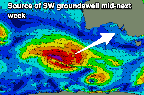
Moving into the middle of the week, and an approaching storm moving in from the west will bring with it a strong S'ly change Tuesday and some poor, localised increase in windswell ahead of a moderate + sized pulse of SW groundswell for Wednesday.
The source of swell for Wednesday will be a strong but slightly disjointed low firing up to the south-west of Western Australia on the weekend, generating gale to severe-galeforce W/NW winds, followed by gale-force W/SW winds.
A good kick in size to 4ft+ is due across Middleton on Wednesday with 1-1.5ft sets on the Mid Coast but with strong S/SE winds. These winds will also whip up similar sized levels of windswell for the South Coast, easing into the end of the week but with winds remaining out of the south. All in all not the best outlook.