Fun weekend of surf on the magnets

South Australian Surf Forecast by Craig Brokensha (issued Friday January 5th)
Best Days: Tomorrow South Coast, Sunday morning South Coast, Wednesday morning South Coast
Features of the Forecast (tl;dr)
- Small, inconsistent background SW-S/SW energy for today and tomorrow, easing Sun
- Variable winds most of tomorrow, N/NE tending weak S/SE Sun
- Late increase in small-mod sized mid-period SW swell Sun, peaking Mon AM with strengthening SW-S/SW winds from dawn
- Smaller Tue with moderate S/SW winds
- Small Wed with E/NE tending S/SE winds
Recap
Workable conditions across the South Coast again yesterday with 3ft of swell and moderate to fresh onshore winds, flat on the Mid Coast. Today looks a touch more ragged and scrappy with a moderate S/SE wind though clearer, sunnier skies.
This weekend and next week (6 - 12)
The weekend ahead will see cleaner conditions develop across the South Coast as an inland trough that's bringing wide-spread instability and rain drifts south-east across the state.
This will see winds tend variable tomorrow morning with a small mix of swells coming in at 2ft across Middleton, with winds possibly remaining variable into the afternoon with the unstable weather. It won't be perfect but generally fun on the right board and with the right mindset.
Sunday should see clean conditions again under a N/NE offshore but with smaller surf to 1-2ft max across Middleton. The magnets will be the pick for a surf.
Later in the day, we may see a new pulse of mid-period SW swell that's due to peak Monday morning, generated by a healthy fetch of strong W/NW winds on the polar shelf, to the south-southwest of Western Australia
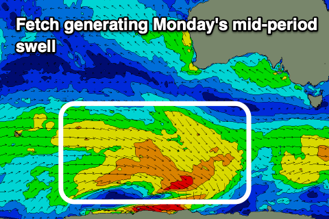
The swell should offer inconsistent 2-3ft sets across Middleton, tiny to flat on the Mid Coast, but unfortunately an onshore flow on the backside of the inland trough will move in right before dawn. Strengthening SW-S/SW winds are due through the day, with an outside chance of dawn W/NW breezes if the trough stalls slightly. This looks very unlikely.
Winds will back off into Tuesday as the trough moves further east but remain moderate out of the S/SW with small 2ft leftovers down South.
Wednesday looks cleaner with a lighter E/NE breeze but no major swell, with background energy persisting in the 2ft range across Middleton.
Longer term, a better swell producer may develop through next week, with a slow moving frontal system pushing under the country early-mid week generate a moderate sized W/SW swell for Friday/Saturday but we'll have a closer look at this on Monday. Have a great weekend!