Fun South Coast waves for the coming days until Tuesday

South Australian Surf Forecast by Craig Brokensha (issued Wednesday December 13th)
Best Days: This morning South Coast (protected spots PM), Friday morning South Coast, Sunday morning South Coast, Monday morning South Coast, Wednesday morning Mid Coast
Features of the Forecast (tl;dr)
- Small, fading swell Thu with W/NW winds, tending gusty SW into the PM
- Good reinforcing S/SW groundswell Thu PM, easing Fri with W/NW winds, tending light-moderate S/SW late AM
- Small Sat with W/NW tending W/SW-SW winds
- Moderate sized mid-period SW swell Sun with N/NE tending SE winds
- Easing swell Mon with N winds, tending S/SE mid-morning
- Moderate sized SW groundswell building Tue PM, peaking later and into Wed
- Strong S/SE winds Tue, S/SE tending S/SW Wed
Recap
Good to great waves across the South Coast yesterday as a strong S/SW groundswell filled in through the day with favourable winds for protected spots around town. Sea breezes were relatively weak keeping conditions decent into the afternoon.
Today the swell is easing but nice and clean across most locations with options all over. The Mid Coast has been tiny but surfable on the beaches for beginners around the lower tides.
This week and weekend (Dec 14 - 17)
The current swell will continue to ease into tomorrow morning and a W/NW breeze will favour protected spots with small 2ft leftovers across Middleton.
A small spike of S/SW groundswell is due through the afternoon, with the source being a tight, short-lived low firing up under the country yesterday, producing a fetch of severe-gale W/NW winds with a couple of storm-force barbs registered.
This is a little stronger than forecast but late in our swell window, though we should see a spike to 3ft through the afternoon across Middleton but with gusty SW winds.
The swell is due to ease on Friday from 2ft to possibly 3ft with a light W/NW breeze due around Victor, tending S/SW later morning but without much strength.
A temporary low point in swell is due on Saturday with a W/NW offshore, shifting W/SW-SW into the afternoon, while a fun pulse of mid-period SW swell is due Sunday as winds shift around to the N/NE.
The source will be back to back weak though broad fronts generating SW winds, and a good kick in swell to 3ft+ across Middleton with building sets to 1ft on the Mid Coast.
Sea breezes will kick in through the afternoon so surf before lunch.
Early Monday looks clean again with easing surf, but a trough will bring a S/SE change mid-morning so you'll have to be quick, with stronger S/SE winds due to kick in behind the trough on Tuesday.
These winds will spoil a good new SW groundswell, generated by a strong polar low forming in the Heard Island region tomorrow afternoon/evening.
A great fetch of severe-gale to storm-force W/SW winds will project east-northeast though weakening on approach under the country on the weekend.
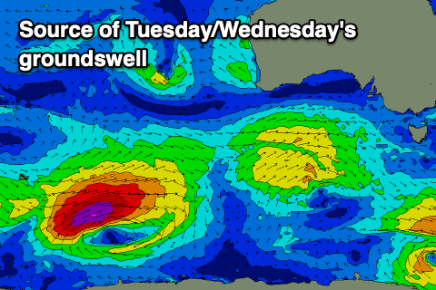
This will produce a moderate sized + SW groundswell that should build through Tuesday and peak late in the day/overnight. Middleton should build to 4-5ft late, with the Mid Coast seeing inconsistent 1-1.5ft sets, likely coming in more around 1-2ft on Wednesday.
Unfortunately winds look to possibly shift back to the S/SW through the day Wednesday, though the morning should see favourable S/SE breezes.
Longer term strong S/SE winds look to dominate the period through the middle to end of next week along with poor levels of localised windswell. So make the most of the current run of decent conditions down South.