Poor weekend, options opening up next week with a strong S/SW groundswell

South Australian Surf Forecast by Craig Brokensha (issued Friday December 8th)
Best Days: Beginners Mid Coast over the weekend, South Coast possibly later Monday but more so Tuesday morning, Wednesday and Thursday morning
Features of the Forecast (tl;dr)
- Small, inconsistent levels of W/SW swell for tomorrow and Sun
- Strong S tending S/SE winds tomorrow, strong SE tending S/SE on Sun
- Moderate sized S/SE windswell building Sun, easing slowly Mon PM
- Fresh SE winds most of Mon, possibly easing into the PM and tending W/NW later
- Mod-large S/SW groundswell building rapidly Tue with W/NW tending fresh SW winds
- Easing swell Wed with N/NW winds
- Small, fading swell Thu with W/NW tending S/SW winds
Recap
A moderate sized, reinforcing W/SW swell maintained fun 2ft waves through yesterday across the Mid Coast, with the rare bigger one still in the mix across the magnets, clean all day. A great run of surf since Tuesday afternoon.
The South Coast was also clean and remained so into the afternoon as heat built ahead of an approaching trough.
The trough is due to move in this afternoon, creating bumpy conditions and bringing cooler weather.


Good waves across both coasts yesterday (Cliffs shot from the PM)
This weekend and next week (Dec 9 - 15)
A S/SW change this afternoon will be followed by stronger S tending S/SE winds tomorrow as a secondary trough arrives and then starts to deepen into a low to our west, squeezing high pressure under Western Australia.
This low will dominate our wind and swell outlook for the weekend and early next week, with the improvement in conditions possibly flagged for Monday morning in Wednesday's update, now being shifted more to the evening if at all.
Coming back to tomorrow and Sunday though, smaller background levels of mid-period W/SW swell should maintain inconsistent 1-1.5ft sets on the favourable parts of the tide for the Mid Coast. Strong SE tending S/SE winds on Sunday will create clean conditions while whipping up a weak, moderate sized S/SE windswell for the South Coast.
The low is due to start drifting south while slowly weakening on Monday, and this will see winds ease and swing around during the day.
Gusty SE winds are due most of Monday, easing into the afternoon and then later possibly shifting W/NW. This scenario would open up some funky options on Monday evening with easing levels of S/SE windswell from 4ft+ or so. The Mid Coast will be tiny.
Tuesday and Wednesday look much better for a surf on the South Coast thanks to the arrival of a new S/SW groundswell with light winds thanks to the low staying south of us while weakening.
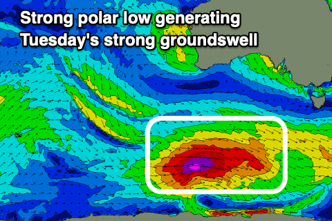
The groundswell looks a little stronger than forecast on Wednesday, with the polar low generating it being quite significant and longer lasting while passing under the country.
A fetch of severe-gale W/NW tending W winds are forecast to project east on the weekend, and then east-northeast under Tasmania Monday, through our southern swell window.
A moderate-large S/SW groundswell is due, building rapidly through Tuesday, peaking into the afternoon, easing Wednesday.
The South Coast should see building 5-6ft sets off Middleton and the local deep water reefs, tiny on the Mid Coast, with easing 4ft surf Wednesday, smaller and 2ft+ Thursday.
A W/NW breeze is likely on Tuesday morning, shifting SW late morning and freshening into the afternoon, with Wednesday seeing N/NW winds that may persist all day (check back here Monday for an update on this).
Thursday morning should be clean again with a W/NW offshore before a trough brings a S/SW change into the afternoon.
Longer term the outllok is a little unclear with all the instability, so check back here on Monday for the latest. Have a great weekend and enjoy the cool change!