Large swells for the South Coast but persistently onshore

South Australian Surf Forecast by Craig Brokensha (issued Monday November 13th)
Best Days: Keen surfers Mid Coast tomorrow, keen surfers South Coast tomorrow and Wednesday morning
Features of the Forecast (tl;dr)
- Moderate sized S/SW for Tue with light-mod S/SE winds, freshening a little into the PM
- Larger S/SW groundswell Wed with moderate S/SE winds, fresh S into the PM
- Easing surf Thu with fresh strong S-S/SE winds
- Smaller Fri with fresh S/SE winds
- Small-mod sized mid-period S/SW swell Sat with moderate SE winds, fresh S/SE into the PM
- Large S/SW groundswell Sun with moderate SE winds, fresh S/SE into the PM
Recap
The weekend started poor across both coasts thanks to a low point in swell and onshore winds left in the wake of a cold front Friday evening.
A new pulse of W/SW swell due later in the day didn't really show, while yesterday provided better surf in the gulf with inconsistent but fun 2ft sets across the magnets when they came. The outgoing tide hurt the size in the morning while conditions were bumpier into the afternoon as it pushed back in.
The South Coast remained average with the onshore winds, a touch better today with a little more east in the wind. The Mid Coast is still offering slow 1-2ft sets for the keen, but the swell is easing and inconsistent on the dropping tide.

Small, clean runners yesterday AM
This week and weekend (Nov 14 - 19)
We've got plenty of swell activity due to impact the South Coast over the coming period thanks to a series of significant storms firing up along the polar shelf this week. The only issue are the local winds.
Firstly into this afternoon and tomorrow, a good pulse of S/SW swell is due, generated by a healthy, broad polar low that fired up over the weekend. This should kick up 4-5ft surf for tomorrow morning (the Mid should hold 1-1.5ft), but of greater interest is a larger S/SW groundswell pulse due later in the day but more so Wednesday.
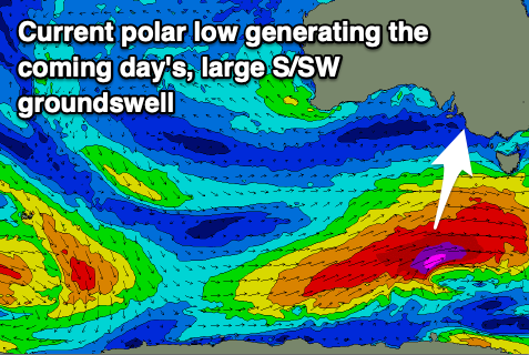
This has been upgraded a touch thanks to the secondary polar fetch coming in the severe-gale to storm-force range, just on the edge of our southern swell window, generating a long-period groundswell pulse that's expected to peak in the 6ft+ range down South, with tiny 1ft waves on the Mid Coast.
This swell will then slowly ease into the end of the week, down from 4ft Thursday morning and 3ft on Friday.
Looking at the local winds and tomorrow isn't ideal but doable with a light S/SE breeze across the South Coast, similar if not a little stronger Wednesday morning and more so moderate in strength. Fresher S'ly winds will be seen into the afternoon.
Thursday and Friday look poor as a series of strengthening polar systems push up and towards Tasmania, squeezing the south-east flank of a strong, stubborn high sitting under Western Australia.
This will bring strengthening S-S/SE winds on Thursday, fresh but still S/SE on Friday morning, tending S'th into the afternoon.
Weaker SE winds are likely on Saturday and Sunday mornings, and with a large, new pulse of S/SW groundswell, generated by one of the frontal systems pushing around the south-east corner of the high.
This almost looks to be a 'bombing' low, dropping 24hPa within a 24 hour period with GFS on board with this scenario, while EC is weaker and only drops 20hPa or so.

Regardless we're set to see a strong polar low forming, generating a fetch of severe-gale to storm-force SW winds in our southern swell window late week.
The groundswell is due Sunday, peaking to a solid 6ft across the South Coast while the Mid Coast will be tiny thanks to the southerly swell direction.
Those SE winds will create bumpy, average conditions, though workable for the keen, while next week looks poor as the swell eases thanks to strengthening winds from the S/SE owing to a deepening trough off the East Coast, squeezing the strong high to our west. More on this Wednesday.