Good swells coming for the Mid but onshore

South Australian Surf Forecast by Craig Brokensha (issued Wednesday October 11th)
Best Days: Today exposed beaches (but windy), protected spots tomorrow morning, early Friday morning (keen surfers) and Saturday/Sunday mornings South Coast, Mid Coast for the keen Friday, South Coast next Tuesday and Wednesday mornings
Features of the Forecast (tl;dr)
- Moderate sized mix of W/SW swells building tomorrow afternoon, peaking Fri AM, easing slowly
- Strong W/NW tending W/SW winds tomorrow, fresh SW tending W/SW on Fri (likely W/NW early Victor)
- Building SW swell Sat with fresh W/NW tending W/SW winds, peaking Sun with moderate W/NW tending stronger W/SW winds
- Easing mid-period S/SW swell and new SW groundswell Mon with gusty S/SE winds
- Easing swell Tue with moderate N/NE-NE winds ahead of sea breezes
- Smaller Wed with N/NE tending S/SE winds
Recap
Lumpy conditions but plenty of size across the South Coast yesterday with a reinforcing W/SW swell to 3ft+ off Middleton. The Mid Coast saw 1ft sets with clean conditions in the morning ahead of sea breezes.
This morning conditions were great early down South with a moderate offshore wind and 2ft+ sets across Middleton and Goolwa, but the wind has quickly strengthened along with a drop in swell to a less consistent 2ft. The Mid was tiny and clean but now choppy. Winds will remain strong from the N/NW this afternoon before easing off into the evening ahead of a late W/SW change as a weakening mid-latitude pushes in from the west. More on this below.

Best waves were found early today
This week and weekend (Oct 12 - 15)
The mid-latitude low that's currently moving in from the west has been a slow moving system, generating a fetch of tight strong to at times gale-force winds south-west of Western Australia, but weaker once passing under the country.
This will produce a moderate sized W/SW swell for later tomorrow and Friday morning, while strong winds associated with the front pushing across us tomorrow will add some windswell to the mix.
The Mid Coast is still expected to reach 2-3ft later in the day, holding that size through Friday with Middleton reaching 3ft late tomorrow and peaking Friday morning to 3-4ft.
Winds are the main issue with strong W/NW winds due do shift SW by late morning tomorrow on the South Coast, easing into Friday but persisting from the SW, shifting back to the W/SW in the gulf through the afternoon. There's a good chance for early W/NW winds around Victor in the morning Friday but the swell conditions will likely be quite raw.
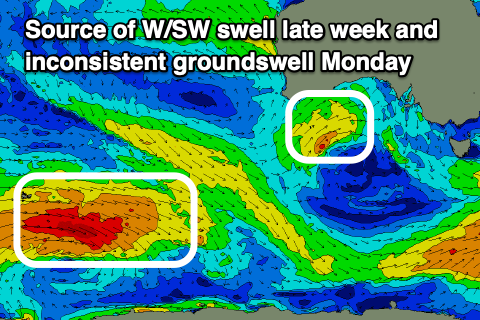
Into the weekend we're due to see building levels of mid-period SW tending S/SW swell as a polar front gets drawn up and towards Victoria Friday/Saturday.
A relatively weak but broad and elongated fetch of strong SW winds will be projected up through the South Coast's swell window, with building surf due Saturday from 2-3ft across Middleton to 3-4ft due later, peaking Sunday to 4ft+. The Mid Coast looks to persist around the slow 1-2ft range on the favourable parts of the tide, with a drop in size due through Monday across both regions.
In saying this, a long-range, inconsistent SW groundswell is due to peak Monday morning, generated by a distant fetch of gale to severe-gales W'ly winds that are attached to a low that's currently around the Heard Island region.
The models are incorrectly combining swells here so expect easing inconsistent sets from the 4ft range.
Coming back to the winds on the weekend and fresh W/NW tending W/SW breezes are due on Saturday, weaker Sunday morning and from a similar direction before strengthening into the afternoon and swinging back onshore. Monday looks poor with gusty S/SE winds, favouring the Mid Coast but there'll only be tiny, easing 1-1.5ft sets on offer.
Easing surf with a shift to N/NE-NE winds is due on Tuesday, favouring the South Coast while Wednesday looks clean again early as the swell bottoms out.
Later next week a good sized SW groundswell is on the cards but winds are still up and in the air so check back here on Friday for the latest.