Fun run for the South Coast with a window for the Mid early week

South Australian Surf Forecast by Craig Brokensha (issued Friday July 28th)
Best Days: South Coast later today, tomorrow, Sunday morning and Monday protected spots, Tuesday all locations, Wednesday South Coast
Features of the Forecast (tl;dr)
- Moderate sized, mid-period S/SW swell building late Fri, peaking Sat AM with fresh to sometimes strong NW winds
- Moderate sized mid-period W/SW swell building Sun with gusty NW tending W/NW and then late W/SW-SSW winds
- Stronger mod-large W/SW-SW swell for Mon with strong but easing W/NW winds
- Swell easing slowly Tue PM with local offshore winds and weak sea breezes
- Easing surf Wed with strengthening N/NE tending N/NW winds
Recap
Great conditions down South with easing surf from Wednesday, backing off from 3ft on the sets while the Mid Coast was 1-2ft at dawn but then mostly 1-1.5ft through the day along with increasing wind chop.
Today the Mid Coast is bumpy but not bad with sets hanging in there at 1-2ft (bigger than expected) while the South Coast is small and clean. A new mid-period S/SW swell is due into the late afternoon down South as winds hold from the NW.

Sets persisting at dawn this AM
This weekend and next week (Jul 29 – Aug 4)
The increase in mid-period S/SW due late today is due to peak tomorrow morning across the South Coast with 3-4ft sets along the Middleton stretch, easing through the day.
The Mid Coast should hold 1-1.5ft and fresh to sometimes strong NW winds will favour the South Coast all day while creating bumpy, choppy conditions across the Mid.
From Sunday we're due to see building levels of mid-period W/SW swell, with a peak due Monday.
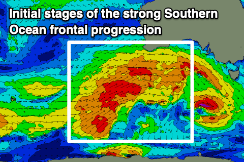
The source will be a strong Southern Ocean frontal progression that's currently projecting up towards Western Australia. Fetches of strong to near gale-force W/SW winds will be produced, initially through our western swell window and then south-western swell window while passing south of us Sunday.
Building surf to a consistent 2ft is due on the Mid Coast Sunday afternoon with building surf to 3ft across the South Coast, with Monday coming in at 3ft on the favourable parts of the tide in the gulf and 4-6ft across the Middleton stretch down South.
The easing trend on Tuesday looks slow with 2-3ft sets across the Mid Coast on the favourable parts of the tide and easing 4-6ft waves down South, smaller Wednesday.
Coming back to the local winds and a gusty NW tending W/NW breeze is due Sunday, shifting W/SW-SW later in the day, with Monday seeing strong W/NW winds, easing later as a small trailing front clips us.

Tuesday still looks to be the pick for the Mid Coast as the front clears bringing light E/NE-NE winds, N/NW down South and variable into the afternoon.
Strengthening N/NE tending N/NW winds will favour the South Coast Wednesday with easing 3-5ft surf.
Longer term a significant Southern Ocean storm is expected to fire up to the south-west of Western Australia, but it's structure and alignment don't look ideal, with the swell focussed more north into the Indian Ocean. We'll have a closer look at this on Monday, have a great weekend!
Comments
after weeks of West swells there's a change in direction today on the cdc data wheel