Strong westerly swells inbound

South Australian Surf Forecast by Craig Brokensha (issued Monday July 3rd)
Best Days: Today South Coast, tomorrow morning South Coast, Thursday South Coast, Saturday morning protected spots South Coast, similar Sunday, Monday both coasts
Features of the Forecast (tl;dr)
- Small SW groundswell tomorrow, easing through the day with N/NW-N tending NW winds
- Mod-large W/SW groundswell Thu with strong N/NW tending NW winds
- Easing swell Fri with strong W/NW winds
- Mod-large mid-period W/SW swell and windswell Sat with strong W/NW tending W/SW winds
- Large, stormy swell Sun with fresh W/SW-SW winds
- Easing large surf Mon with NE tending variable winds on the Mid, N/NW down South
Recap
Nothing of note in the gulf with tiny 0.5-1ft sets, cleanest yesterday, while the South Coast saw fresh onshore winds but plenty of swell to 3-4ft Saturday morning, improving through the day as winds eased.
Yesterday was the pick with lighter winds and lumpy but still solid 3-4ft waves across Middleton, again improving and ironing out through the day.
For those with flexibility, today is the pick with a bit less swell but great conditions along with smaller, easing 2ft sets.

Shapely this afternoon
This weekend and next week (Jul 4 - 9)
Later today we may see a small, tricky SW groundswell arriving, generated by a fetch of gale to severe-gale NW winds, aimed towards the polar shelf. We should still see some small, inconsistent waves spreading up and into us from this fetch, peaking overnight to 2-3ft across Middleton but then easing from 2ft tomorrow morning.
Winds will be great for the magnets though with a N-N/NW offshore, tending NW into the afternoon but with smaller surf.
It looks like Wednesday will be a lay day as the swell bottoms out under fresher N/NE tending N/NW winds.
Come Thursday, a stronger N/NW breeze is due, shifting NW later afternoon along with a moderate to large pulse of W'ly groundswell.
The source of this swell will be a strong low that's formed to the south-west of Western Australia with a fetch of gale to severe-gale W/SW-SW winds being aimed through our western swell window.
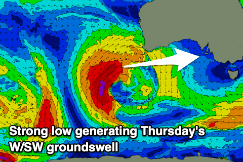
The position of the low isn't ideal for the South Coast with Kangaroo Island again putting in some blocking, but size wise we should see the Mid Coast coming in at a strong 3ft but with those poor winds, 3-4ft across Middleton with bigger sets down off Goolwa.
Winds are due to shift W/NW on Friday as the W'ly swell eases, with protected spots down South offering the cleanest but smallest waves.
The backside of the low might slow the easing trend a touch across both coasts but the Mid will be down to a messy 2-3ft, with easing 3-4ft waves down South.
Now, moving into the weekend, the next flurry of strong frontal activity will push in from the Bight, generating back to back fetches of strong to gale-force winds followed by gale to severe-gale W/SW winds.
The first frontal system will move in Friday evening, followed by the secondary front Saturday evening resulting in building stormy surf on the Mid Coast with a peak Sunday, similar down South.

We're looking at stormy 3ft to possibly 4ft waves on Saturday across the Mid Coast, building to 3-5ft on Sunday with the South Coast coming in at 6-8ft Sunday with larger waves across the deep water reefs.
Winds will be hammering though and strong from the W/NW tending W/SW through Saturday, easing Sunday but still W/SW-SW in the morning.
Monday looks great as winds ease and tend N/NW down South with possible NE winds across the Mid Coast as the large surf eases back from 6ft+ and 3ft respectively.
Longer term there's a ton more activity on the cards, but check back here Wednesday for the latest.