Fading surf on the Mid, plenty of fun days down South

South Australian Surf Forecast by Craig Brokensha (issued Wednesday May 17th)
Best Days: Both coasts today, South Coast tomorrow, South Coast Friday morning, Sunday morning South Coast, Monday and Tuesday South Coast
Features of the Forecast (tl;dr)
- Easing surf Thu with light N/NW-NW winds ahead of weak sea breezes, E/NE-NE on the Mid
- Building mix of S/SW swells Fri PM with freshening W/NW tending fresh W/SW winds into the PM
- Moderate sized swell Sat with fresh SW-S/SW winds, likely W/NW early around Victor
- Slightly stronger swell Sun with early W/NW winds, shifting SW
- Moderate sized + swell Mon with W/NW-N/NW tending S/SW winds
- Peak in S/SW groundswell early Tue, easing with N/NW winds
Recap
The South Coast offered large surf yesterday with a short period of W/NW winds before gusty SW winds kicked in, shifting SE into the afternoon. The Mid Coast was a little bumpy and lumpy with variable S'ly winds but slow 1-2ft sets, best as the tide pushed in early afternoon.
This morning conditions were cleaner down South but a little lumpy and with plenty of size left in the tank, coming in at 3-5ft while the Mid Coast was a slow 1-2ft, and is pulsing nicely with the incoming.

Fun sets hanging in today
This week and weekend (May 18 - 21)
Smaller surf is due into tomorrow morning and conditions will be great across the South Coast with a light N/NW-NW offshore ahead of weak sea breezes, E/NE-NE on the Mid Coast ahead of weak sea breezes. Easing sets from 3ft to occasionally 4ft are due across Middleton, with the Mid Coast becoming tiny in size, smaller Friday morning.
Winds will freshen a little from the W/NW during Friday, favouring the South Coast with 2-3ft sets left across Middleton.
Into the afternoon but more so Saturday, some new mid-period S/SW swell energy is due, generated by unconsolidated, patchy frontal activity on the polar shelf and south-west of Tasmania.
More consistent sets to 3ft are due into later Friday and Saturday across Middleton as the Mid Coast comes in at 0.5-1ft.
The window for clean conditions on Saturday is minimal with a front pushing through just after dawn, bringing a fresh SW tending S/SW change. There should be a dawn W/NW'ly for the keen around Victor.
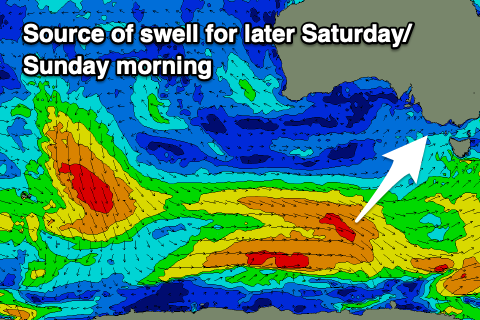
From later Saturday but more so Sunday further increases in swell are due, growing in period and size ahead of the strongest increase in size later Monday/Tuesday morning.
These swells will be generated by back to back frontal systems moving along the polar shelf, with an initial broad fetch of strong W/NW winds due to produce 3ft+ waves into Sunday morning down South, tiny on the Mid Coast.
A secondary stronger and broader system will produce pre-frontal W/NW gales, followed by severe-gale W'ly winds, kicking up more size Monday to 4-5ft in the morning, with the odd 6ft'er due to be in the mix later in the day and Tuesday morning.

All the activity will be a little too south to favour the Mid Coast, leaving 1ft surf for beginners.
Local winds on Sunday look similar to Saturday, generally SW, with a period of early W/NW winds around Victor, while Monday and Tuesday look cleaner with a light W/NW and N/NW breeze respectively due each morning, holding all day on Tuesday.
Longer term a stronger cold outbreak looks to bring large, stormy surf into the end of the week and next weekend, but we'll have a closer look at this on Friday.