Fun run for the South Coast

South Australian Surf Forecast by Craig Brokensha (issued Monday November 7th)
Best Days: South Coast all period - exposed beaches tomorrow morning and Wednesday, Thursday morning, Friday morning, Saturday morning, Sunday
Features of the Forecast (tl;dr)
- Small, mid-period S/SW swell for tomorrow PM and Wed AM
- Mod-fresh N/NE tending NE winds tomorrow, weaker E/SE into the PM
- Strong NE tending weaker N/NE then possibly W/SW winds late PM Wed
- Moderate sized mix of S/SW swells building Thu, holding Fri AM
- W/NW tending SW winds Thu
- Light SE winds Fri, increasing into the PM
- Easing S/SW swell Sat with mod-fresh E/NE-NE tending SE winds
- Smaller Sun with strengthening NW-W/NW winds
Recap
Great surf over the weekend with pumping waves and conditions as a moderate sized S/SW swell was groomed by offshore winds both Saturday and Sunday. There were options aplenty from big long walls to heavy, fast barrels.
The Mid Coast was tiny and ideal for beginners across the beaches.
Today the surf has dropped away but conditions were again great down South with 2ft+ sets across Middleton, tiny to flat on the Mid Coast.
This week and weekend (Nov 8 - 13)
We've got a great week of surf ahead for the South Coast with generally favourable winds each morning before going a little flakey late in the week.
Tomorrow and Wednesday will be on the smaller side, but we should see the surf remaining in the 2ft range across Middleton as some small, mid-period S/SW swell arrives, stopping the easing trend from the weekend.
This is being generated by a weak polar front that's skirting the polar shelf and won't impact the Mid Coast's swell window.
Exposed breaks will be best and a moderate to fresh N/NE tending NE breeze will favour these spots before weak E/SE sea breezes kick in tomorrow.
Wednesday will see strong NE winds, easing early afternoon and tending N/NE before a trough brings a late afternoon W/SW wind shift, possibly revering back offshore later.
The trough will be linked to a weak mid-latitude low moving in slowly from the west, with it expected to move across us Thursday while weakening further.
This will result in weak W/NW tending SW winds on Thursday as a moderate sized, mid-period S/SW swell fills in, then more variable SE on Friday with a reinforcing pulse of slightly stronger SW groundswell.
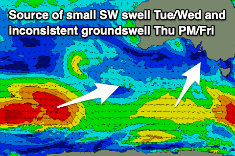 These swells are being generated by a slightly stronger polar frontal system that's currently south-southwest of Western Australia.
Yesterday this front was generating gale-force winds in our far swell window, but it's now weaker and will continue to decay while tracking east today and tomorrow. This will result in mid-period energy arriving Thursday morning ahead of the stronger, more groundswelly sets into the afternoon and Friday.
Looking at Thursday morning and we should see good 3ft waves across Middleton with that morning W/NW breeze, while the stronger sets should provide 3-4ft sets into the afternoon, holding Friday morning before easing. It'll be inconsistent so expect a wait for the sets.
The Mid Coast isn't due to see any major size with infrequent 0.5-1ft sets later Thursday and Friday morning.
The light SE breeze won't be perfect for the South Coast Friday but we should still see fun waves, while easing surf from 2-3ft on Saturday as winds swing back to the NE but come in moderate to fresh.
Sunday is a little tricky wind wise with a trough likely brining a shift back to the NW through the morning and W/NW into the afternoon. We'll review this Wednesday.
Longer term a couple of stronger polar lows should generate some decent S/SW groundswell into next week with winds a little unsure. More on this in Wednesday's update.