Plenty more swell for the Mid as winds deteriorate

South Australian Surf Forecast by Craig Brokensha (issued Monday October 10th)
Best Days: Late tomorrow South Coast, Wednesday both coasts, Friday morning protected spots down South, Mid Coast Saturday for the keen, Sunday down South
Features of the Forecast (tl;dr)
- Low point in swell tomorrow AM with strong N/NE tending N/NW winds, easing later
- Fun, inconsistent S/SW swell for late tomorrow, peaking Wed AM, then easing. Light N/NW tending W/NW winds Wed (variable on the Mid in the AM)
- Small-moderate sized W swell for Wed through Sat, strongest Wed PM and Fri
- Freshening W/NW winds Thu, gusty W/NW tending W/SW Fri
- Mix of swells Sat with a weak S/SW change
- New SW groundswell for late Sat, peaking Sun with variable winds ahead of sea breezes
Recap
Great surf on the Mid Coast all weekend with a mix of good sized W/SW swells Saturday to 2-3ft, workable in protected spots down South with a good increase in size also to 3ft.
Sunday was better and cleaner down South with a reinforcing S/SW swell pushing wave heights to 3-4ft, a bit better than expected while the Mid dropped back to a fun 2ft.
Today the swell has eased back across both coasts, wind affected and tiny on the Mid Coast, best down South and back to 2ft across Middleton.

Lumpy but a good size early Sat AM
This week and weekend (Oct 11 - 16)
 The coming week looks generally small for the South Coast apart from one pulse of fun S/SW swell later tomorrow but more so Wednesday morning. Our attention will focus on the Mid Coast where there's plenty of surf due but winds will unfortunately deteriorate.
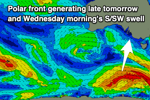
Looking at tomorrow and we'll see the current swell continuing to fade in size along with strong N/NE tending N/NW winds, easing through the afternoon. It'll be small to tiny across Middleton ahead of a new S/SW very late in the day.
This new S/SW swell was generated yesterday afternoon and evening by a healthy polar low to the south-southwest of Tasmania, generating a fetch of strong to at times gale-force W/SW winds.
It should provide 2ft sets on dark tomorrow across Middleton with 2-3ft waves Wednesday morning, easing through the day under N/NW tending W/NW winds.
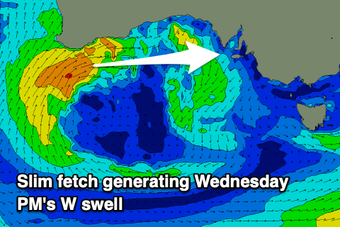 Now, coming back to the Mid Coast and a broad, slow moving mid-latitude low has formed south of Western Australia and it's already projected a fetch of weak W/SW winds towards us. The low will strengthen today, projecting a secondary fetch of slimmer W/SW winds through our swell window, but too far north in latitude for the South Coast.
The low is then due to move east while weakening a touch, stalling in the Bight and aiming a persistent fetch of strong W/SW-SW winds towards us.
The low will finally move east and across us on Friday, bringing strong W/NW tending W/SW winds with it.
All this wind activity will generate a moderate sized W-W/SW swell, with the first pulse arriving overnight tomorrow, peaking Wednesday morning ahead of a stronger pulse of energy into the afternoon.
1-2ft sets are due Wednesday morning, kicking to a better 2ft into the afternoon, holding Thursday while Friday will see a mix of windswell and mid-period energy to 2ft+.
With winds not being overly strong on Wednesday, this looks the pick for the Mid Coast, while Thursday will deteriorate as winds freshen from the W/NW.
The South Coast isn't due to see any size until Friday but with a mix of weak energy coming in at 2-3ft with those favourable W/NW winds in the morning.
Now, moving into the weekend, we'll see a stronger, strengthening frontal system pushing in behind the low, generating a fetch of strong to gale-force W/SW winds through our south-western swell window Friday afternoon and evening, generating a moderate sized SW swell for late Saturday but more so Sunday.
The front will clip us Saturday bringing a shallow S/SW change, but Sunday looks decent with a variable morning breeze and peak in swell to 3-4ft across Middleton. The Mid Coast looks tiny and to 1-1.5ft but fun for the keen.
Follow up storms look patchy but enough to generate reinforcing pulses of moderate sized swell for next week ahead of a possible significant storm and swell mid-late next week. More on this in the coming updates though.