Summer like period in mid-winter

South Australian Surf Forecast by Craig Brokensha (issued Monday Jul 4th)
Best Days: Tomorrow for the keen South Coast, Wednesday morning South Coast, Saturday for the keen South Coast, Sunday South Coast
Features of the Forecast (tl;dr)
- Easing mix of S/SW swells tomorrow, smaller Wed
- Moderate E/NE tending variable winds tomorrow and N/NW tending W/NW on Wed
- Tiny W/SW swell for Thu PM with S/SE tending S/SW winds
- Poor Fri with gusty S/SE winds
- Inconsistent, small mid-period SW swell Sat and Sun AM
- Light, variable S/SE winds Sat AM, and N Sun
Recap
Clean, tiny waves for beginners and bigger boards across the Mid Coast Saturday, clean and fun down South with 3-4ft sets out of the S/SW.
Yesterday was a bit smaller and lumpier, poor today with a moderate to fresh SE breeze. The Mid Coast is clean but just a tease and 0.5-1ft max for beginners.
This week and weekend (Jul 5 - 10)
Having a quick glance at the forecast for the coming week to fortnight, it's not very winter like at all. Instead of westerly winds and tons of swell we've got summer looking surf with smaller, weak swells and south-east winds.
The lingering La Niña signal and dominant high pressure systems, broken up by troughs looks to continue to influence our local weather and surf potential for the medium term.
The current run of SE winds is thanks to a strong low off the southern NSW coast, squeezing a strong high sitting south-west of us, spanning the Bight.
We'll see a weak front moving in from the west tomorrow and Wednesday morning, bringing moderate E/NE winds tomorrow morning, easing into the afternoon and then light N/NW tending W/NW winds on Wednesday.
Size wise, moderate sized S/SW energy seen into today will ease back through tomorrow from 2-3ft, while our reinforcing pulse of swell for Wednesday has been downgraded a touch with small 2ft waves due across Middleton. The Mid Coast will see infrequent 1ft sets continuing tomorrow and Wednesday as some distant, infrequent W/SW swell energy fills in.
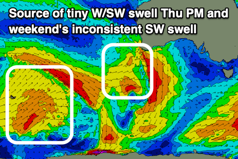 Into Thursday we'll fall behind the weak front moving through overnight Wednesday and a new, building high pressure with fresh S-S/SW winds due across the South Coast, S/SE tending S/SW on the Mid Coast. There'll be a tiny hint of new W/SW swell from front moving under WA today and tomorrow with sets to 1-1.5ft through the afternoon, easing Friday from 1ft with gusty S/SE winds.
Moving into the weekend there's some inconsistent mid-period SW swell due across the South Coast and with lighter winds.
The source of this swell is a broad but relatively weak frontal progression that's taking place to the south-west of Western Australia. Infrequent 2ft to occasionally 3ft sets are due across Middleton both Saturday and Sunday morning with Sunday being cleanest. A light, variable S/SE breeze is due on Saturday with N'ly winds Sunday.
Another trough will bring a strong S/SW change Monday afternoon with a localised S/SW windswell in its wake Tuesday/Wednesday but we'll have a closer look at this Wednesday.