Fun waves tomorrow ahead of onshore breezes Sunday

South Australian Surf Forecast by Craig Brokensha (issued Friday Jul 1st)
Best Days: South Coast tomorrow, South Coast Tuesday morning and Wednesday
Features of the Forecast (tl;dr)
- Building moderate sized S/SW swell today, easing slowly tomorrow with light N/NW tending light SE winds
- Reinforcing moderate sized S/SW swell Sun with fresh E/SE-SE winds
- Good S/SW groundswell building Mon with moderate SE tending S/SE winds, easing Tue with E/NE tending SE winds
- Fun reinforcing mid-period S/SW swell Wed with N/NE tending N/NW winds
- Tiny, inconsistent W/SW swell for the Mid Mon to Wed
Recap
Average, deteriorating conditions across the South Coast with a bit of new swell, while the Mid Coast saw improving conditions and good 2ft sets with a new W'ly swell and developing S/SE winds. The afternoon was best before the tide got to it later.
Today conditions are glassy and 1.5ft on the Mid Coast with a bit of size on the South Coast but poor conditions.

Semi-clean 2ft+ waves yesterday afternoon
This weekend and next week (Jul 2 - 8)
Currently we're seeing a high move in behind a surface trough and change Wednesday evening, while a low is forecast to develop off the southern NSW coast this weekend, preventing the high from pushing further east.
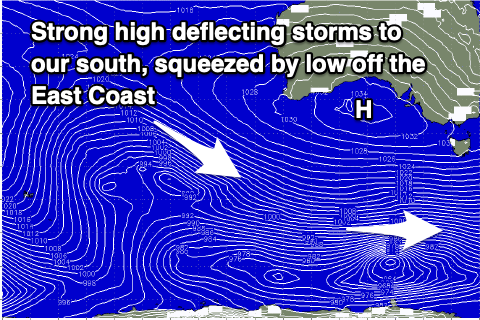 This is bringing the south-east winds and they look to persist through the weekend and early next week, but there's a window of better, offshore N/NW breezes due tomorrow morning down South, only giving into weak sea breezes.
It'll be worth making the most of as Sunday looks poor as winds revert back to the E/SE-SE, moderate in strength before freshening through the afternoon.
Swell wise, we've got good pulse of moderate sized S/SW swell with an initial pulse this afternoon which should hold 3-4ft tomorrow morning, dropping back to 3ft during Sunday.
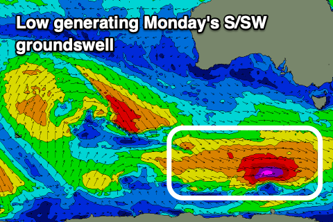
Looking at Monday and we've got our strong pulse of S/SW groundswell due, generated by a strong but fast moving polar low under the country this evening and tomorrow. A tight fetch of severe-gale to storm-force W'ly winds are due, producing a good 3-4ft of S/SW groundswell for Monday afternoon down South when it peaks.
 Winds will remain average and moderate out of the SE, shifting S/SE through the day. We'll likely see E/NE winds on Tuesday morning as the swell drops back from the 3ft range.
Wednesday and Thursday look much better for a surf with a reinforcing mid-period S/SW swell for the former and a N/NE tending N/NW breeze ahead of a surface trough. The source of this reinforcing swell will be a polar front generating pre and post-frontal W/NW-SW winds, with sets to 3ft due across Middleton, easing through the day.
The Mid Coast won't see any size from these swells, but some very infrequent, tiny background W/SW swell energy should provide 1ft sets Monday through Wednesday.
Beyond this the end of the week looks slow but we should see some good new, moderate sized SW groundswell for later Sunday/Monday next week. Winds look favourable from the northern quadrant, but more on this Monday. Have a great weekend!