Fun options for both regions over the coming days

South Australian Surf Forecast by Craig Brokensha (issued Monday June 27th)
Best Days: Today, South Coast magnets tomorrow, South Coast for the keen Wednesday morning, Mid Coast Thursday, Saturday, Sunday and Monday mornings South Coast
Features of the Forecast (tl;dr)
- Easing mix of swells tomorrow with N/NE tending N/NW winds
- Small, inconsistent W/SW groundswell Wed with strengthening N tending W winds (late afternoon)
- Fun W'ly swell Thu with SE tending fresher S/SE winds
- Building moderate sized S/SW swell Fri with S/SE winds, holding Sat with E/NE tending SE winds, easing Sun with similar winds
- Further pulses of S/SW swell next week
Recap
Friday afternoon's building mix of swell energy peaked through Saturday with fun, clean 3-4ft waves across Middleton while the Mid Coast was a bumpy 2ft.
Sunday saw slightly cleaner conditions across the Mid with a slight drop in swell back to 1-2ft while the South Coast remained a fun 3-4ft.
Today we've still got 3-4ft sets across Middleton with great conditions, cleaner on the Mid Coast and hanging in at 1-2ft. Winds should remain favourable all day with fun surf across both coasts into this afternoon.


Fun Mid and South Coast waves this morning
This week and weekend (Jun 28 – Jul 3)
The current mix of swell energy will ease into this afternoon and tomorrow, leaving tiny 1ft+ waves on the Mid Coast and fading 2ft sets across Middleton under a favourable N/NE tending N/NW breeze. Hit the South Coast magnets for all the action.
 Into Wednesday we've got a tricky new pulse of small W/SW groundswell, generated by a strong but south-east tracking fetch of W/NW-NW winds through our swell window, south-west of Western Australia on the weekend.
This may generate 1-1.5ft sets on the Mid Coast but with fresh N tending W winds, while the South Coast looks to offer inconsistent 2ft sets.
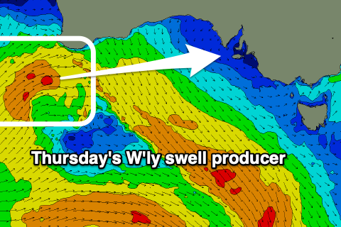
A better W'ly swell is due Thursday across the Mid, generated by a better mid-latitude front passing under the Western Australian south coast today, providing 2ft surf as winds swing around to the S/SE in the wake of Wednesday's change. The morning should see a light SE offshore, and the South Coast will be poor and bumpy with small 2ft sets max.
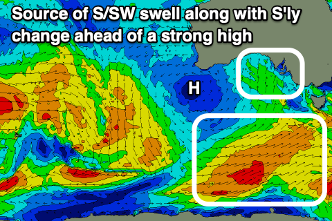
This change will be linked to a trough pushing east, and it's forecast to deepen along the East Coast as a high moving in from the west stalls.
 Winds will persist out of the S/SE generally through Friday and the weekend but we might see pockets of E/NE breezes down South depending on where the trough deeps along the East Coast.
Swell wise, we've got moderate pulses of S/SW swell with a range of periods, generated by a healthy polar frontal progression along the polar shelf.
The models are over-forecasting the size from this direction along the South Coast with surf to 3-4ft expected across Middleton from Friday afternoon through Saturday, easing Sunday with some further pulses likely next week. Winds should improve slowly next week but we'll have a closer look at this on Wednesday and Friday. Either way lighter E/NE breezes are more than likely Saturday and Sunday mornings.
Comments
The info on the surf forecast page is not consistent with this analysis. Look at wind data for example.
You talking about the coming weekend? As stated in the notes there's room for movement with the low forming off the East Coast.
Thursday morning for example, you say “ light SE offshore” and the forecast page says 23 knots. You mention 2’ waves and the forecast page shows 0.5’.
Agh I see, the Mid Coast point is located further west and closer towards Kangaroo Island so has stronger winds than expected in the gulf. And generally the size is under-forecast by the buoy point which we are aware of and have a fix for. So keep an eye on my notes for a more accurate forecast.