Plenty of swell for both coasts with workable winds

South Australian Surf Forecast by Craig Brokensha (issued Friday June 24th)
Best Days: Mid Coast this afternoon, early tomorrow for the keen, Sunday and Monday morning - South Coast tomorrow, Sunday morning, Monday and early Tuesday
Features of the Forecast (tl;dr)
- Moderate sized + mix of W/SW-SW swells building this afternoon, holding tomorrow with a reinforcing pulse later, steadying Sun AM, then easing
- Freshening NW tending W/NW winds tomorrow (lighter early on the Mid)
- W/NW tending SW winds Sun down South, W/SW tending S/SW and then S/SE late on the Mid
- Easing mix of swells Mon with local offshore tending NE winds down South, variable NW on the Mid
- Fading surf with strengthening N winds Tue
- Moderate sized W/SW swell Wed with gusty W/NW winds
- Larger S/SW swell building Thu, peaking Fri with strong S/SW winds
Recap
Bumpy, deteriorating surf across the Mid Coast with easing 1-1.5ft sets and strengthening N'ly wind, cleaner down South but tiny.
Today we've got a mix of building W/SW swells and workable onshore winds on the Mid with bumpy small waves down South. We should see our new mix of mid-period W/SW swell and groundswell building through this afternoon reaching 2ft+ on the Mid Coast and 3-4ft across Middleton as winds swing SW down South and remain light to moderate W/SW on the Mid Coast.

Cape du Couedic on the way up
This weekend and next week (Jun 25 – Jul 1)
The Cape du Couedic wave buoy is on the rise and we'll see our mix of mid-period and groundswell energy kicking strongly this afternoon, peaking tomorrow and holding Sunday morning as a reinforcing pulse of mid-period energy moves in.
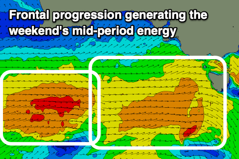
All this swell was generated by the same strong storm progression that originated from an initial slow moving low in the southern Indian Ocean, with the remnants now moving under the country as a healthy mid-latitude frontal progression.
 We'll see mid-period W/SW-SW energy being the most consistent and best on the weekend along with infrequent sets of W/SW groundswell and Middleton should come in around 4ft with 2ft+ sets on the Mid Coast tomorrow, easing back from a similar size down South Sunday morning and 2ft on the Mid Coast.
Locally winds will be best for the South Coast tomorrow and freshening from the NW tending W/NW with lighter morning NW winds on the Mid. W/NW winds are due Sunday morning but a weak front will bring a SW change around midday, with the Mid Coast seeing moderate W/SW tending S/SW winds, then around to the S/SE on dark (well worth the afternoon and evening surf).
Monday should be clean across all locations but smaller with easing 1-2ft sets across the Mid Coast and dropping 3ft+ sets down South. Local offshore N/NE winds are due down South, only tending NE into the afternoon with NE tending variable NW winds on the Mid Coast.
The swell will reach a low point in size on Tuesday as winds strengthen from the N/NE tending N/NW. Don't expect much over 2ft down South across Middleton, easing through the day.
Moving into the middle to end of the week and a weak mid-latitude front pushing in from the west will bring a W/NW change and mix of mid-period W/SW swell and windswell across the Mid Coast but with choppy conditions. Sets to 2ft+ are likely as the South Coast remains small and to 2ft.
A stronger polar front projecting up towards and then over Victoria late week will bring poor S/SW winds and a sizey though stormy S/SW swell for the South Coast as the Mid Coast eases in size but we'll have a closer look at this Monday. Have a great weekend!