Stormy surf over the coming days

South Australian Surf Forecast by Craig Brokensha (issued Monday May 30th)
Best Days: South Coast Thursday, protected spots South Coast Saturday and Sunday morning
Features of the Forecast (tl;dr)
- Stormy increase in mod-large S/SW swell tomorrow with strong W/SW-SW winds (possibly lighter at times around Victor)
- Easing S/SW swell Wed with strong, abating SW winds
- Easing S/SW swell Thu with N/NE tending fresher N/NW winds
- Small leftovers Fri with strengthening N/NW tending W/NW winds
- New, mid-period W/SW swell Sat and Sun AM
- Fresh W/NW winds Sat, fresh W/NW tending SW Sun
Recap
Small to tiny waves all weekend on the Mid Coast either side of 1.5ft with workable winds, while the South Coast offered 2ft sets across Middleton on Saturday, better yesterday morning and to 2-3ft.
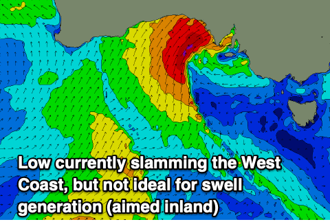
Today we've seen a cold, mid-latitude low starting to edge in from the west bringing wide ranging heavy rainfalls but swell wise, the South Coast was back to a tiny 1-1.5ft, choppy and small on the Mid Coast.
This week and weekend (May 31 – Jun 5)
Looking at the current synoptic setup and we've got a broad, cold low projecting gale-force SW winds into the far West, and we'll see this low pushing east across us this afternoon, bringing strong S/SW winds but no quality swell with it.
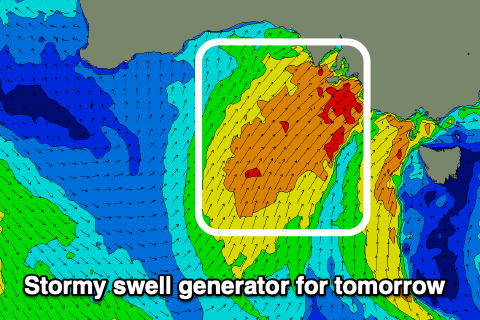
 Strong W/SW winds are expected tomorrow as well fall under the influence of the backside of the low, along with some moderate-large sized, weak, building S/SW swell.
This will be thanks for a fetch of strong to gale-force S/SW winds being projected up and into us, generating 4-6ft of stormy swell for Middleton and semi-stormy 3ft waves on the Mid Coast.
The low will clear to the east on Wednesday but winds look to linger from the SW, strong in the morning and more so moderate to fresh into the afternoon. Unfortunately there'll be nowhere to recommend as the S/SW swell eases.
 Thursday looks to be the pick of the week and for the South Coast with offshore N/NE tending fresher N/NW winds but smaller, easing S/SW sets from the 3ft range across Middleton. Our models are over-forecasting the size and mixing swells to expect easing head-high surf if not for the odd bigger one early.
Come Friday the swell will be at a low point and winds will strengthen from the N/NW ahead of a W/NW change as another, weaker mid-latitude storm approaches from the west.
This secondary low should generate small pulses of mid-period W/SW swell for the weekend, with patchy fetches of below gale-force W/SW winds only likely to produce 3ft surf across Middleton Saturday, easing from a similar size Sunday and with 1-1.5ft sets on the Mid Coast. Local winds won't be ideal but workable with fresh W/NW breezes Saturday and W/NW tending SW winds on Sunday. We'll review this again Wednesday.
Unfortunately longer term there's still nothing of significance as mid-latitude systems linked to the lingering Nina signal and negative Indian Ocean Dipole make for uninteresting swell generators. More on this in the coming updates.