Fun weekend for the South Coast

South Australian Surf Forecast by Craig Brokensha (issued Friday May 27th)
Best Days: South Coast tomorrow and Sunday morning, protected spots Wednesday morning down South, Thursday down South
Features of the Forecast (tl;dr)
- Inconsistent mid-period SW swell building this afternoon, with a better pulse tomorrow, easing Sun
- NW-N/NW winds Sat, light-mod N-N/NW tending fresh NE Sun
- Strengthening NW tending W/NW winds Mon with smaller surf in the AM, possibly building later
- NW windswell building on the Mid Mon
- Mix of SW windswell on the Mid Tue and building moderate sized + S/SW swell down South with strong SW winds
- Easing S/SW swell Wed with W/NW tending SW winds
- Easing S/SW swell Thu with N/NW winds
Recap
Clean but tiny surf down South, while the Mid Coast saw some new weak W/SW swell to 1-1.5ft with workable onshore winds for the keen.
Today is cleaner on the Mid though still a little lumpy and peaky with 1-1.5ft sets on the magnets, clean but tiny down South again.
This weekend and next week (May 28 – Jun 3)
Into this afternoon some new, inconsistent mid-period SW swell is due across the state, followed by a better increase tomorrow. Theses swells have impacted Western Australia nicely, generated by broad but patchy polar low that formed around the Heard Island region on the weekend.
Fun, inconsistent 2-3ft sets are due across Middleton, more to 3ft towards Goolwa while the Mid Coast should continue around 1ft to occasionally 1.5ft. Winds will be favourable for the South Coast most of the day as a strengthening polar front come broad low pushes up into our west, directing persistent N/NW-NW winds across the region.
The swell should start easing through Sunday from 2-3ft and winds will remain favourable for the South Coast, N-N/NW in the morning then fresher NE into the afternoon as the low starts to move east.
 Monday looks to be a lay day with the swell easing further from the weekend under strengthening NW tending W/NW winds ahead of an evening W/SW change. This will kick up a building windswell for the Mid Coast to 2-3ft through the day but with no quality.
We may see some small, mid-period W/SW swell arriving later in the day down South from the initial stages of the storm developing to our west, but with the strong winds, conditions will be average in all but protected spots (sheltered from the W/SW energy).
The low proper will move across us on Tuesday, bringing strong SW winds, and a secondary front pushing up behind the low looks to bring a moderate sized + increase in mid-period S/SW swell later in the day to 4-5ft+. The Mid Coast looks to maintain semi-stormy 2-3ft waves.
The low is due to clear to the west on Tuesday evening, while a secondary approaching front will swing winds back to the W/NW through the morning down South Wednesday (check back Monday for confirmation).
 This will be with easing levels of mid-period S/SW swell from a similar 4-5ft+, 2ft on the Mid Coast.
Thursday looks cleaner again but smaller under N/NW breezes.
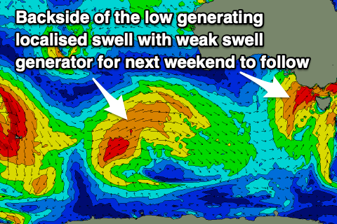
Moving into the end of the week and next weekend, the approaching frontal system bringing the improving winds will be a broad, slow moving system and looks to produce some fun, moderate sized W/SW swell Friday afternoon and more so Saturday.
At this stage the Mid Coast should come in 2-3ft, with 4-5ft sets down South, though spoilt by strong SW winds as the backside of the low moves across us. This will produce some additional windswell to the mix, but check here on Monday for a more detailed breakdown. Have a great weekend!